U.S. Geological Survey Open-File Report 2013–1003
Sea-Floor Geology in Northeastern Block Island Sound, Rhode Island
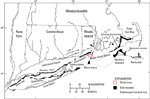
Block Island Sound is south of Rhode Island, bounded by Fishers Island, New York on the west, the eastern end of Long Island, N.Y., on the southwest, Block Island, R.I., on the south, and Rhode Island Sound on the east (fig. 2). The sea floor in and around Block Island Sound is marked by evidence of glacial fluctuation and marine transgression. The furthest extent of the Laurentide Ice Sheet is delineated by the Ronkonkoma-Nantucket terminal moraine, which was deposited about 20,000 to 24,000 years ago (Uchupi and others, 2001) and extends across the southern border of Block Island and Block Island Sound (fig. 2). As the ice sheet regressed northward, the Harbor Hill-Roanoke Point-Charlestown-Buzzards Bay moraine was deposited about 18,000 years ago (Uchupi and others, 2001). Melting ice formed glacial lakes between the front of the ice sheet and the end moraines, within which sediments tens to hundreds of meters thick were deposited in Long Island, Block Island, and Rhode Island Sounds and Narragansett Bay (Needell and others, 1983; Lewis and DiGiacomo-Cohen, 2000; Uchupi and others, 2001). The glacial lakes eventually drained, exposing these areas to subaerial erosion, before sea level rose and transgressed across the area presently covered by the sounds. Transgression eroded the sea floor, including deposits on submerged moraines, leaving a coarse-grained lag (Knebel and others, 1982). Presently, wind- and wave-generated currents erode, sort, and rework Holocene and underlying sediments on the sea floor, and, where currents are weak, modern marine sediments are deposited (Knebel and others, 1982; Needell and Lewis, 1984).
|

![]() U.S. Department of the Interior |
U.S. Geological Survey
U.S. Department of the Interior |
U.S. Geological Survey
URL: http://pubsdata.usgs.gov/pubs/of/2013/1003/html/setting.html
Page Contact Information: GS Pubs Web Contact
Page Last Modified: Wednesday, 21-Aug-2013 16:12:34 EDT