U.S. Geological Survey Open-File Report 2013–1003
Sea-Floor Geology in Northeastern Block Island Sound, Rhode Island
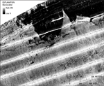
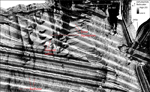
The sidescan-sonar mosaic shows areas of high backscatter (light tones), which indicate coarser grained sediments and hard bottom, and areas of low backscatter (dark tones), which indicate finer grained sediments and acoustic shadows (fig. 16). Although the backscatter tones are not always matched and stripes occur from line to line creating artifacts in the data, several distinct patterns are visible in the mosaic. One pattern is a high-backscatter target with a low-backscatter shadow, which is caused by individual boulders; another pattern is an area of high backscatter surrounded by low backscatter, with a sharp distinction between the two caused by scour depressions and erosional outliers (fig. 17); another feature is an area of high- and low-backscatter stripes oriented roughly perpendicular to the shore (fig. 18). The sharp contrast in backscatter around scour depressions reflects the contrast in texture and about 0.5-m change in depth between the scour depressions and the surrounding sea floor and erosional outliers. Low backscatter along the coast is probably produced by finer grained, sandy sediments, while high backscatter further seaward and to the south is related to the scour depressions and gravelly and bouldery areas. A scoured area in the north-central part of the study area tends to have east-west oriented features rather than the north-south oriented extensions of other near-shore scour depressions (fig. 18). These features are to the west of a jetty protecting Point Judith Harbor, which probably adds to the complexity of waves and currents that form and maintain the scour depressions in this area. An area of roughly shore-perpendicular, striped backscatter is to the southwest of the jetty at the entrance to the Point Judith Harbor (fig. 18). These features are interpreted to be broad, low-relief bedforms that have finer grained crests and coarser material in the troughs, which produces the striping (fig. 13). The bedforms have north-south oriented crests and wavelengths of tens of meters. Although they are apparent in the sidescan-sonar mosaic, any bathymetric expression of these features is below the resolution of the MBES data. |

![]() U.S. Department of the Interior |
U.S. Geological Survey
U.S. Department of the Interior |
U.S. Geological Survey
URL: http://pubsdata.usgs.gov/pubs/of/2013/1003/html/sidescan.html
Page Contact Information: GS Pubs Web Contact
Page Last Modified: Wednesday, 21-Aug-2013 16:12:34 EDT