Open-File Report 2013–1027
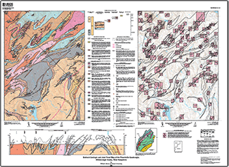
AbstractThe bedrock geology of the Pinardville quadrangle includes the Massabesic Gneiss Complex, exposed in the core of a regional northeast-trending anticlinorium, and highly deformed metasedimentary rocks of the Rangeley Formation, exposed along the northwest limb of the anticlinorium. Both formations were subjected to high-grade metamorphism and partial melting: the Rangeley during the middle Paleozoic Acadian orogeny, and the Massabesic Gneiss Complex during both the Acadian and the late Paleozoic Alleghanian orogeny. Granitoids produced during these orogenies range in age from Devonian (Spaulding Tonalite) to Permian (granite at Damon Pond), each with associated pegmatite. In the latest Paleozoic the Massabesic Gneiss Complex was uplifted with respect to the Rangeley Formation along the ductile Powder Hill fault, which also had a left-lateral component. Uplift continued into the early Mesozoic, producing the 2-kilometer-wide Campbell Hill fault zone, which is marked by northwest-dipping normal faults and dilational map-scale quartz bodies. Rare, undeformed Jurassic diabase dikes cut all older lithologies and structures. A second map is a compilation of joint orientations measured at all outcrops in the quadrangle. There is a great diversity of strike trends, with northeast perhaps being the most predominant. |
First posted November 5, 2013
For additional information contact: Or William C. Burton Part or all of this report is presented in Portable Document Format (PDF). For best results viewing and printing PDF documents, it is recommended that you download the documents to your computer and open them with Adobe Reader. PDF documents opened from your browser may not display or print as intended. Download the latest version of Adobe Reader, free of charge. |
Burton, W.C., and Armstrong, T.R., 2013, Bedrock geologic and joint trend map of the Pinardville quadrangle, Hillsborough County, New Hampshire: U.S. Geological Survey Open-File Report 2013–1027, one sheet, scale 1:24,000, http://pubs.usgs.gov/of/2013/1027/.

![]() U.S. Department of the Interior |
U.S. Geological Survey
U.S. Department of the Interior |
U.S. Geological Survey
URL: http://pubsdata.usgs.gov/pubs/of/2013/1027/index.html
Page Contact Information: GS Pubs Web Contact
Page Last Modified: Tuesday, 03-Dec-2013 08:00:18 EST
