Poppe, Larry, 2013, H12012_BOTPHOTOS.SHP: Locations of Sea-Floor Photographs Acquired During U.S. Geological Survey (USGS) Cruise 2010-015-FA Offshore in Northeastern Long Island Sound (Geographic, WGS84): Open-File Report 2013-1060, U.S. Geological Survey, Coastal and Marine Geology Program, Woods Hole Coastal and Marine Science Center, Woods Hole, MA.This is part of the following larger work.Online Links:
- <http://pubs.usgs.gov/of/2013/1060/data/botphotos/h12012_botphotos.zip>
- <http://pubs.usgs.gov/of/2013/1060/data/botphotos/h12012_botphotos.txt>
- <http://pubs.usgs.gov/of/2013/1060/data/botphotos/h12012_botphotos.xls>
- <http://pubs.usgs.gov/of/2013/1060/html/catalog.html>
Poppe, L.J., McMullen, K.Y., Ackerman, S.D., and Glomb, K.A., 2013, Sea-Floor Geology and Topography Offshore in Northeastern Long Island Sound: Open-File Report 2013-1060, U.S. Geological Survey, Coastal and Marine Geology Program, Woods Hole Coastal and Marine Science Center, Woods Hole, MA.Online Links:
This is a Vector data set. It contains the following vector data types (SDTS terminology):
Horizontal positions are specified in geographic coordinates, that is, latitude and longitude. Latitudes are given to the nearest 0.000001. Longitudes are given to the nearest 0.000001. Latitude and longitude values are specified in Decimal degrees.
The horizontal datum used is D_WGS_1984.
The ellipsoid used is WGS_1984.
The semi-major axis of the ellipsoid used is
6378137.000000.
The flattening of the ellipsoid used is 1/298.257224.
Sequential unique whole numbers that are automatically generated.
Coordinates defining the features.
Characters and numerics identifying sampling sites
Characters and numerics identifying photos. Combination of station and photo number.
Character String: Months, days, and year as m/dd/yyyy
| Range of values | |
|---|---|
| Minimum: | 41.200302 |
| Maximum: | 41.25806 |
| Units: | Decimal degrees |
| Resolution: | 0.000001 |
| Range of values | |
|---|---|
| Minimum: | -72.400539 |
| Maximum: | -72.16467 |
| Units: | Decimal degrees |
| Resolution: | 0.000001 |
| Value | Definition |
|---|---|
| MID-SIZED SEABOSS GRAB | Mid-sized USGS Seabed Observation and Sampling System (SEABOSS) |
2010-015-FA
| Value | Definition |
|---|---|
| SURVEY H12012 IN LONG ISLAND SOUND | Project name assigned by scientist |
| Value | Definition |
|---|---|
| LPOPPE | Larry Poppe |
Numerics separated by colons
(508) 548-8700 x2314 (voice)
(508) 457-2310 (FAX)
lpoppe@usgs.gov
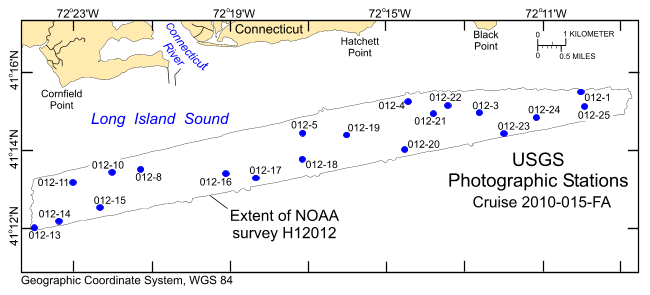
The purpose of this dataset is to release the locations and identifiers of 64 photographs from the sea floor collected at 20 stations on bathymetry data from offshore in northeastern Long Island Sound in geographic, WGS84.
Person who carried out this activity:
(508) 548-8700 x2314 (voice)
(508) 457-2310 (FAX)
lpoppe@usgs.gov
Data sources produced in this process:
Person who carried out this activity:
508-548-8700 x2314 (voice)
508-457-2310 (FAX)
lpoppe@usgs.gov
Data sources produced in this process:
Blackwood, D., and Parolski, K., 2001, Seabed observation and sampling system: Sea Technology v. 42, no. 2, p. 39-43.
Poppe, L.J., DiGiacomo-Cohen, M.L., Doran, E.F., Smith, S.M., Stewart, H.F., and Forfinski, N.A., 2007, Geologic interpretation and multibeam bathymetry of the sea floor in the vicinity of the Race, eastern Long Island Sound: Open-File Report 2007-1012, U.S. Geological Survey, Coastal and Marine Geology Program, Woods Hole Coastal and Marine Science Center, Woods Hole, MA.Online Links:
Poppe, L.J., Denny, J.F., Williams, S.J., Moser, M.S., Forfinski, N.A., Stewart, H.F., and Doran, E.F., 2007, The geology of Six Mile Reef, eastern Long Island Sound: Open-File Report 2007-1191, U.S. Geological Survey, Coastal and Marine Geology Program, Woods Hole Coastal and Marine Science Center, Woods Hole, MA.Online Links:
McMullen, K.Y., Poppe, L.J., Danforth, W.W., Blackwood, D.S., Schaer, J.D., Ostapenko, A.J., Glomb, K.A., and Doran, E.F., 2010, Surficial geology of the sea floor in Long Island Sound offshore of Plum Island, New York: Open-File Report 2010-1005, U.S. Geological Survey, Coastal and Marine Geology Program, Woods Hole Coastal and Marine Science Center, Woods Hole, MA.Online Links:
Poppe, L.J., McMullen, K.Y., Ackerman, D.S., Blackwood, D.S., Irwin, B.J., Schaer, J.D., Lewit, P.G., and Doran, E.F., 2010, Sea-floor geology and character offshore of Rocky Point, New York: Open-File Report 2010-1007, U.S. Geological Survey, Coastal and Marine Geology Program, Woods Hole Coastal and Marine Science Center, Woods Hole, MA.Online Links:
McMullen, K.Y., Poppe, L.J., Danforth, W.W., Blackwood, D.S., Schaer, J.D., Guberski, M.R., Wood, D.A., and Doran, E.F., 2011, Surficial geology of the sea floor in Long Island Sound offshore of Orient Point, New York: Open-File Report 2010-1100, U.S. Geological Survey, Coastal and Marine Geology Program, Woods Hole Coastal and Marine Science Center, Woods Hole, MA.Online Links:
Poppe, L.J., McMullen, K.Y., Ackerman, S.D., Blackwood, D.S., Schaer, J.D., Forrest, M.R., Ostapenko, A.J., and Doran, E.F., 2011, Sea-floor geology and topography offshore in eastern Long Island Sound: Open-File Report 2010-1150, U.S. Geological Survey, Coastal and Marine Geology Program, Woods Hole Coastal and Marine Science Center, Woods Hole, MA.Online Links:
McMullen, K.Y., Poppe, L.J., Danforth, W.W., Blackwood, D.S., Schaer, J.D., Glomb, K.A., and Doran, E.F., 2012, Sea-floor geology of Long Island Sound north of Duck Pond Point, New York: Open-File Report 2011-1149, U.S. Geological Survey, Coastal and Marine Geology Program, Woods Hole Coastal and Marine Science Center, Woods Hole, MA.Online Links:
Poppe, L.J., McMullen, K.Y., Ackerman, S.D., Guberski, M.R., and Wood, D.A., 2013, Sea-floor character and geology off the entrance to the Connecticut River, northeastern Long Island Sound: Open-File Report 2013-1060, U.S. Geological Survey, Coastal and Marine Geology Program, Woods Hole Coastal and Marine Science Center, Woods Hole, MA.Online Links:
All attributes were checked in a consistent manner
Navigation was by differential GPS. Although GPS gave the ship's position rather than that of the SEABOSS, the antenna was located less than 5 m from the block on the A-frame, water depths were generally shallow, and scope of the cable minimal. Therefore, SEABOSS offset from the antenna was less than 10 m.
Locations of all still photographs of the sea floor collected within the study area during the OSV Bold cruise 2010-015-FA were included in this data set. Total station numbers range from 012-1 to 012-25, but there are no stations 012-2, 012-7, 012-9 and 012-12 due to weather. No still photos were taken at 012-6 because of extreme turbidity.
No additional checks for topological consistency were performed on this data.
Are there legal restrictions on access or use of the data?
- Access_Constraints: None
- Use_Constraints:
- Public domain data from the U.S. government are freely redistributable with proper metadata and source attribution. Please recognize the U.S. Geological Survey (USGS) as the source of this information.
(508) 548-8700 x2314 (voice)
(508) 457-2310 (FAX)
lpoppe@usgs.gov
Downloadable Data
Neither the U.S. Government, the Department of the Interior, nor the USGS, nor the National Oceanic and Atmospheric Administration (NOAA), nor the Connecticut Department of Energy and Environmental Protection (CT DEEP) nor any of their employees, contractors, or subcontractors, make any warranty, express or implied, nor assume any legal liability or responsibility for the accuracy, completeness, or usefulness of any information, apparatus, product, or process disclosed, nor represent that its use would not infringe on privately owned rights. The act of distribution shall not constitute any such warranty, and no responsibility is assumed by the USGS, NOAA, or the CT DEEP in the use of these data or related materials. Any use of trade, product, or firm names is for descriptive purposes only and does not imply endorsement by the U.S. Government.
| Data format: | A zip file containing the geospatial data, metadata describing the data set, and a browse graphic showing the data layer coverage and extent. The Excel (2003) and TEXT versions of the data are also available in the WinZip file. in format SHP (version ArcView 3.3) Esri point shapefile Size: 46 kb |
|---|---|
| Network links: |
<http://pubs.usgs.gov/of/2013/1060/data/botphotos/h12012_botphotos.zip> <http://pubs.usgs.gov/of/2013/1060/html/catalog.html> |
| Media you can order: |
DVD-ROM
(Density 4.75
Gbytes)
(format UDF)
|
These data are available in Environmental Systems Research Institute (Esri) shapefile format. The user must have ArcGIS or ArcView 3.0 or greater software to read and process the data file. In lieu of ArcView or ArcGIS, the user may utilize another GIS application package capable of importing data. A free data viewer, ArcExplorer, capable of displaying the data is available from Esri at www.esri.com. The user must have software capable of uncompressing archived zip files, such as Winzip or Pkware. The Excel (2003) and TEXT versions of the data are also available in the WinZip file.
508-548-8700 x2314 (voice)
508-457-2310 (FAX)
lpoppe@usgs.gov
Downloadable Data
Neither the U.S. Government, the Department of the Interior, nor the USGS, nor the National Oceanic and Atmospheric Administration (NOAA), nor the Connecticut Department of Energy and Environmental Protection (CT DEEP) nor any of their employees, contractors, or subcontractors, make any warranty, express or implied, nor assume any legal liability or responsibility for the accuracy, completeness, or usefulness of any information, apparatus, product, or process disclosed, nor represent that its use would not infringe on privately owned rights. The act of distribution shall not constitute any such warranty, and no responsibility is assumed by the USGS, NOAA, or the CT DEEP in the use of these data or related materials. Any use of trade, product, or firm names is for descriptive purposes only and does not imply endorsement by the U.S. Government.
| Data format: | First record contains field headings. Data fields are comma separated. in format ASCII text file Size: 7 kb |
|---|---|
| Network links: |
<http://pubs.usgs.gov/of/2013/1060/data/botphotos/h12012_botphotos.txt> <http://pubs.usgs.gov/of/2013/1060/html/catalog.html> |
| Media you can order: |
DVD-ROM
(Density 4.75
Gbytes)
(format UDF)
|
These data are available as a generic ASCII formatted text file. The user must have a software program capable of reading the comma-delimited data file.
508-548-8700 x2314 (voice)
508-457-2310 (FAX)
lpoppe@usgs.gov
Downloadable Data
Neither the U.S. Government, the Department of the Interior, nor the USGS, nor the National Oceanic and Atmospheric Administration (NOAA), nor the Connecticut Department of Energy and Environmental Protection (CT DEEP) nor any of their employees, contractors, or subcontractors, make any warranty, express or implied, nor assume any legal liability or responsibility for the accuracy, completeness, or usefulness of any information, apparatus, product, or process disclosed, nor represent that its use would not infringe on privately owned rights. The act of distribution shall not constitute any such warranty, and no responsibility is assumed by the USGS, NOAA, or the CT DEEP in the use of these data or related materials. Any use of trade, product, or firm names is for descriptive purposes only and does not imply endorsement by the U.S. Government.
| Data format: | First record contains field headings. in format XLS Excel file Size: 30 kb |
|---|---|
| Network links: |
<http://pubs.usgs.gov/of/2013/1060/data/botphotos/h12012_botphotos.xls> <http://pubs.usgs.gov/of/2013/1060/html/catalog.html> |
| Media you can order: |
DVD-ROM
(Density 4.75
Gbytes)
(format UDF)
|
These data are available as an Excel formatted (.xls) file created with Excel 2003. The user must have a software program capable of reading Excel files.
(508) 548-8700 x2314 (voice)
(508) 457-2310 (FAX)
lpoppe@usgs.gov