U.S. Geological Survey Open-File Report 2013–1060
Sea-Floor Geology and Topography Offshore in Northeastern Long Island Sound
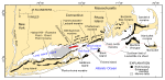
Long Island Sound, a major Atlantic Coast estuary surrounded by the most densely populated region of the United States, is 182 km long and as much as 32 km wide. It is bordered on the north by the rocky shoreline of Connecticut, on the east by The Race and Block Island Sound, and on the south by the eroding sandy bluffs of Long Island. Bedrock that underlies southeastern Connecticut and, presumably, the survey area consists mostly of Precambrian (?) and Paleozoic gneisses and granites of the Avalonian terrane and, to a lesser extent, Merrimack synclinorium (Rodgers, 1985). The Avalonian rocks form an anticlinorium that is locally intruded by the Westerly Granite (Permian?), a fine-grained component of the Narragansett Pier Plutonic Suite (Rodgers, 1985). The bedrock under eastern Long Island Sound has been acoustically mapped, revealing a southward-dipping surface cut by south-southeast-trending bedrock valleys (Grim and others, 1970; Lewis and Needell, 1987). Unconformably overlying the bedrock are isolated erosional remnants of coastal plain deposits of Cretaceous age, consisting of unconsolidated to semi-consolidated gravels, sands, silts, and clays (Lewis and Needell, 1987). Paleozoic bedrock and (or) coastal-plain strata beneath Long Island Sound are unconformably overlain by two sheets of glacial drift. The older of these sheets is commonly attributed to pre- to late-Wisconsinan events (Illinoian?), whereas the younger sheet is a product of the late Wisconsinan ice advance (Sirkin, 1982). Traces of two late Wisconsinan end-moraines cross Long Island (Schafer and Hartshorn, 1965; Sirkin, 1982; Stone and Borns, 1986). The Ronkonkoma moraine, which marks the maximum southern extent of the late Wisconsinan glaciation about 20–24 thousand years before present (kyBP), lies across central and southeastern Long Island and extends eastward across the shelf in the direction of Block Island (fig. 2; Balco and others, 2002; Boothroyd and Sirkin, 2002). The Harbor Hill-Roanoke Point-Orient Point moraine, a second moraine line that caps northern Long Island and extends eastward across Fishers Island and southern Rhode Island, records a readvance of the ice sheet 18–21 kyBP (Uchupi and others, 1996, Balco and others, 2002; Balco and others, 2009; Poppe and others, 2012). As the ice sheet retreated from this moraine, meltwater was dammed behind the Harbor Hill-Fishers Island-Charlestown moraine, and a pro-glacial lake formed in the area now occupied by Long Island Sound (Lewis and Stone, 1991). During this time coastal deltas prograded into the lake, and thick deposits of fine-grained glaciolacustrine sediments accumulated on the lake bottom (Lewis and DiGiacomo-Cohen, 2000). A notch (The Race) cut in the Harbor Hill-Fishers Island-Charlestown moraine at the eastern end of the sound is inferred to be the spillway for glacial Lake Connecticut (Stone and others, 2005). Other less prominent recessional moraines are also present between the two major moraine belts on eastern Long Island and in southeastern Connecticut, recording minor glacial readvances or stalled positions during the ice sheet's retreat (Flint and Gebert, 1976; Goldsmith, 1982; Sirkin, 1982; Stone and others, 2005). A late Wisconsinan-Holocene sequence of fluvial erosion (associated with the draining of the glacial lake that occupied Long Island Sound) was followed by a marine transgression and a subsequent transition to present conditions (Lewis and Stone, 1991). Although erosion at the spillway located in The Race lowered lake levels, and the bed of glacial Lake Connecticut was completely exposed by 15.5 kyBP, the rising sea started to invade the sound by 15 kyBP (Stone and others, 2005). Marine conditions were well established in the sound's basin by 13.5 kyBP, and glacial Lake Hitchcock in central New England was beginning to drain down the Connecticut River valley (Lewis and DiGiacomo-Cohen, 2000). The Hitchcock lake-bottom sediment, transported south by the Connecticut River between 13.5 and 9.5 kyBP (inferred to be about 11.5 billion m³), buried the marine unconformity and built a large marine delta (fig. 2; Stone and others, 2005). Circulation within Long Island Sound is tidally dominated. It is stronger in constricted areas such as the opening at its funnel-shaped eastern end, where a large volume of water must pass through a relatively narrow opening, and is weaker in the broad deeper basin of the central sound (Gordon and Philbeam, 1975; Signell and others, 2000). Although wind- and wave-driven currents are relatively important in shallow nearshore areas, especially during aperiodic storms when strong winds blow the length of the sound, fresher water entering the western sound creates a longitudinal salinity gradient that imparts a weak gravitational circulation (Signell and others, 2000). Modeling suggests that this combination of tidal and estuarine circulation is an effective sediment transport mechanism that is capable of eroding the marine deltaic deposits of the eastern sound, redistributing them westward into the estuary, and building and maintaining longitudinally directed shoals such as Six Mile Reef and Long Sand Shoal (Signell and others, 2000; Poppe and others, 2008b). Scouring and redistribution of glacial and younger sediments by the strong tidal currents are common in eastern Long Island Sound and these currents have a significant influence on surficial sediment distributions (Poppe and others, 2000). Tidal currents can locally exceed 1.3 m/s within the study area (White and White, 2012), and tidal currents at 1 m above the sea floor have been modeled at 30 to 50 cm/s, with the higher current speeds being in the eastern part of the central study area (Signell and others, 2000). The flood tide in the vicinity of the study area, which flows westward, is stronger than the ebb tide. The study area lies about 3.7 km off the mouth of the Connecticut River, which is the largest river in New England, exceeding 650 km in length and draining about 29,137 km² (Bacon, 1906; Hard, 1947). Mean freshwater discharge from this river is about 483 m³/s, but maximum discharge during the spring snow melt and after storms is about 7,985 m³/s. The river also carries large concentrations of sediment, especially during peak flows. This sediment builds and maintains shoals and affects turbidity throughout much of the eastern sound, including the study area (Poppe and others, 2013). |

![]() U.S. Department of the Interior |
U.S. Geological Survey
U.S. Department of the Interior |
U.S. Geological Survey
URL: http://pubsdata.usgs.gov/pubs/of/2013/1060/html/setting.html
Page Contact Information: GS Pubs Web Contact
Page Last Modified: Friday, 27-Sep-2013 09:23:43 EDT