Skip Links

USGS - science for a changing world
DOD Task Force for Business and Stability Operations Logo
Afghanistan Geological Survey Logo

Open-File Report 2013–1276

Prepared in cooperation with the Afghan Geological Survey under the auspices of the U.S. Department of Defense

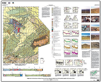
Geologic Map of the Shaida Deposit and Misgaran Prospect, Herat Province, Afghanistan, Modified from the 1973 Original Map Compilation of V.I. Tarasenko and Others

Compiled by Robert D. Tucker, Will R. Stettner, Linda M. Masonic, and Thomas W. Moran

Thumbnail of and link to report PDF (32.4 MB)Introduction

This map is a modified version of Geological map and map of useful minerals, Shaida area, scale 1:50,000, which was compiled by V.I. Tarasenko, N.I. Borozenets, and others in 1973. Scientists from the U.S. Geological Survey, in cooperation with the Afghan Geological Survey and the Task Force for Business and Stability Operations of the U.S. Department of Defense, studied the original document and related reports and also visited the field area in August 2010.

This modified map illustrates the geological structure of the Shaida copper-lead-zinc deposit and Misgaran copper-lead-zinc prospect in western Afghanistan and includes cross sections of the same area. The map reproduces the topology (contacts, faults, and so forth) of the original Soviet map and cross sections and includes modifications based on our examination of these documents and on observations made during our field visit. Elevations on the cross sections are derived from the original Soviet topography and might not match the newer topography used on the current map. We have attempted to translate the original Russian terminology and rock classification into modern English geologic usage as literally as possible without changing any genetic or process-oriented implications in the original descriptions. We also use the age designations from the original map.

The unit colors on the map and cross sections differ from the colors shown on the original version. The units are colored according to the color and pattern scheme of the Commission for the Geological Map of the World (CGMW) (http://www.ccgm.org).

First posted April 28, 2014

For additional information, contact:
Office of International Programs
U.S. Geological Survey
917 National Center
12201 Sunrise Valley Drive
Reston, VA 20192 http://international.usgs.gov/index.htm

Or

Robert D. Tucker
U.S. Geological Survey
926A National Center
12201 Sunrise Valley Drive
Reston, VA 20192
Email: rtucker@usgs.gov

Part or all of this report is presented in Portable Document Format (PDF). For best results viewing and printing PDF documents, it is recommended that you download the documents to your computer and open them with Adobe Reader. PDF documents opened from your browser may not display or print as intended. Download the latest version of Adobe Reader, free of charge.


Suggested citation:

Tucker, R.D., Stettner, W.R., Masonic, L.M., and Moran, T.W., comps., 2014, Geologic map of the Shaida deposit and Misgaran prospect, Herat Province, Afghanistan, modified from the 1973 original map compilation of V.I. Tarasenko and others: U.S. Geological Survey Open-File Report 2013‒1276, 1 sheet, scale 1:50,000, http://dx.doi.org/10.3133/ofr20131276.

ISSN 0196-1497 (print)

ISSN 2331-1258 (online)


Contents

Introduction

Description of Map Units

Explanation of Map Symbols

References Cited


Accessibility FOIA Privacy Policies and Notices

Take Pride in America logo USA.gov logo U.S. Department of the Interior | U.S. Geological Survey
URL: http://pubsdata.usgs.gov/pubs/of/2013/1276/index.html
Page Contact Information: GS Pubs Web Contact
Page Last Modified: Monday, 28-Apr-2014 14:37:01 EDT