U.S. Geological Survey Open-File Report 2013-1284
Shapefile for Coastal Zone Management Program Counties of the United States and Territories, 2009 (CZMP_counties_2009.shp)
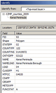
The USGS shapefile of CZMP counties (CZMP_counties_2009.shp) uses attributes (fig. 2) from the U.S. Census Bureau (2009) TIGER/Line shapefile of U.S. counties and equivalent entities (tl_2009_us_county.shp). These attributes are defined below: STATEFP The attribute STATEFP provides the Federal Information Processing Standards (FIPS) code for the U.S. state, commonwealth, or territory in which the county or equivalent entity is located. As a convenience for users unfamiliar with FIPS codes, the shapefile folder includes a spreadsheet that provides the FIPS codes, names, and two-letter abbreviations of the relevant U.S. states, commonwealths, and territories (National Institute of Standards and Technology, 1987). If desired, the information in this spreadsheet can be used to create supplemental attributes for the shapefile. COUNTYFP The attribute COUNTYFP provides the FIPS code for the county or equivalent entity. COUNTYNS The attribute COUNTYNS provides the American National Standards Institute (ANSI) code for the county or equivalent entity, as used by GNIS. CNTYIDFP The attribute CNTYIDFP provides the combined state and county FIPS codes (STATEFP and COUNTYFP). NAME The attribute NAME provides the current name of the county or equivalent entity, without the associated legal/statistical area description (county, parish, borough, census area, and so forth). NAMELSAD The attribute NAMELSAD provides the current name of the county or equivalent entity, along with the associated legal/statistical area description (county, parish, borough, census area, and so forth).LSAD The attribute LSAD provides the U.S. Census Bureau’s legal/statistical area description (LSAD) code for the county or equivalent entity; refer to the formal metadata included with the shapefile for a key to the LSAD codes. Additional Attributes: CLASSFP, MTFCC, CSAFP, CBSAFP, METDIVFP, and FUNCSTAT are attributes that provide additional codes the U.S. Census Bureau uses to characterize counties and equivalent entities; refer to the formal metadata included with the shapefile for further explanation. |

![]() U.S. Department of the Interior |
U.S. Geological Survey
U.S. Department of the Interior |
U.S. Geological Survey
URL: http://pubsdata.usgs.gov/pubs/of/2013/1284/attributes.html
Page Contact Information: GS Pubs Web Contact
Page Last Modified: Friday, 13-Dec-2013 15:35:36 EST