Open-File Report 2014-1040
Polygons of Global Undersea Features for Geographic Searches
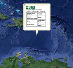
The data were compiled in ArcGIS® version 9.3.1 (http://resources.arcgis.com/). The downloadable file has been compressed with the "send to compressed folder" tool in the Windows® operating system and may be extracted by Windows® Explorer or other utilities capable of uncompressing a ZIP file. The zipped file includes data, metadata, projection parameters, and a browse graphic. The metadata also are provided online in several formats: parseable text, HyperText Markup Language (HTML), frequently asked questions HTML (FAQ), and Extensible Markup Language (XML). The zipped file may be used as is in applications such as the ArcGISSM Online map viewer (http://www.arcgis.com/home/webmap/viewer.html). The unzipped shapefile can be viewed by many GIS applications. The undersea_features.kmz file is a version of the dataset suitable for viewing in Google EarthTM, a virtual-globe data viewer (fig. 3). A free version of Google EarthTM may be downloaded from https://www.google.com/earth/. The linked data representation can be incorporated in a triple store that supports GeoSPARQL queries (Open Geospatial Consortium, 2012).
|

![]() U.S. Department of the Interior |
U.S. Geological Survey
U.S. Department of the Interior |
U.S. Geological Survey
URL: http://pubsdata.usgs.gov/pubs/of/2014/1040/ofr2014-1040-data_usage.html
Page Contact Information: GS Pubs Web Contact
Page Last Modified: Monday, 25-Jun-2018 10:07:31 EDT