Open-File Report 2014-1040
Polygons of Global Undersea Features for Geographic Searches
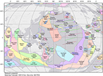
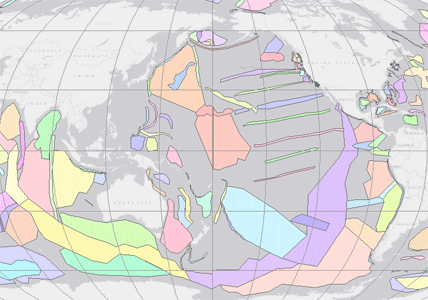
Each undersea feature in the dataset is represented by a simplified polygon that includes the footprint of the feature. This footprint was derived through examination of historical bathymetric maps, bathymetric raster data, and primary scientific literature. Given our purpose in compiling the spatial extents of undersea features—to facilitate the search and retrieval of georeferenced information resources related to marine regions—we have determined that these simplified polygons are suitable for systems that permit users to search irregular geographic areas. It must be remembered, however, that the polygons are not authoritative spatial representations of the features in question. This caveat must be kept in mind if the USGS spatial extents of undersea features are used for purposes other than the search and retrieval of georeferenced information resources (for example, as a display layer in a geographic information system). The polygon shapefile, which includes 311 undersea features, is in unprojected geographic coordinates (decimal degrees) referenced to World Geodetic System 1984 (WGS 84) as the horizontal datum. The geographic extent of the shapefile to the nearest degree is 0° E to 0° W longitude and 75° S to 90° N latitude. The shapefile folder also includes a virtual-globe representation of the dataset (KMZ file), suitable for viewing in Google Earth™. Figure 1 shows selected undersea features from the dataset. The new linked data representation of 299 of these undersea features and their spatial extents is provided in Turtle format, the Terse RDF Triple Language endorsed by the World Wide Web Consortium (W3C; 2014). A second Turtle file provides supporting information—the undersea feature designations, codes, and definitions employed in GNS (see United States Board on Geographic Names, 2005).
|

![]() U.S. Department of the Interior |
U.S. Geological Survey
U.S. Department of the Interior |
U.S. Geological Survey
URL: http://pubsdata.usgs.gov/pubs/of/2014/1040/ofr2014-1040-dataset.html
Page Contact Information: GS Pubs Web Contact
Page Last Modified: Monday, 25-Jun-2018 10:08:36 EDT