 Summary Summary
The Waldo Canyon Fire of 2012 was one of the most destructive wildfire events in Colorado history. The fire burned a total of 18,247 acres, claimed 2 lives, and destroyed 347 homes. The Waldo Canyon Fire continues to pose challenges to nearby communities. In a preliminary emergency assessment conducted in 2012, the U.S. Geological Survey (USGS) concluded that drainage basins within and near the area affected by the Waldo Canyon Fire pose a risk for future debris flow events. Rainfall over burned, formerly vegetated surfaces resulted in multiple flood and debris flow events that affected the cities of Colorado Springs and Manitou Springs in 2013. One fatality resulted from a mudslide near Manitou Springs in August 2013. Federal, State, and local governments continue to monitor these hazards and other post-fire effects, along with the region’s ecological recovery.
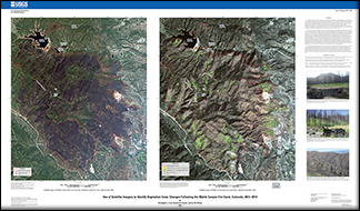
At the request of the Colorado Springs Office of Emergency Management, the USGS Special Applications Science Center developed a geospatial product to identify vegetation cover changes following the 2012 Waldo Canyon Fire event. Vegetation cover was derived from July 2012 WorldView-2 and September 2013 QuickBird multispectral imagery at a spatial resolution of two meters. The 2012 image was collected after the fire had reached its maximum extent. Per-pixel increases and decreases in vegetation cover were identified by measuring spectral changes that occurred between the 2012 and 2013 image dates. A
Normalized Difference Vegetation Index (NDVI), and Green-Near Infrared Index (GRNIR) were computed from each image.
These spectral indices are commonly used to characterize vegetation cover and health condition, due to their sensitivity to detect foliar chlorophyll content. Vector polygons identifying surface-cover feature boundaries were derived from the 2013 imagery using image segmentation software. This geographic software groups similar image pixels into vector objects based upon their spatial and spectral characteristics. The vector dataset was then populated with the per-pixel spectral change information to provide an estimated percentage of vegetation increase or decrease of pixels within each polygon. Information collected during a field visit to the Waldo Canyon burn scar in September 2013 was used to help validate this assessment (see photographs 1–3). The numbers on the satellite images correspond to the location of the photographs.
For display purposes, the polygons shown on the map represent areas where significant decrease or increase in vegetation cover occurred. Only polygons that held a 70 percent or greater cover change are shown on this map (a GIS dataset with complete information is available upon request). A significant increase in vegetation cover was found in the burned area. This increase is likely due to the growth of grasses and other herbaceous vegetation. Minimal vegetation cover decrease was detected at this threshold. This product is meant to provide a broad survey of post-fire vegetation trends within the Waldo Canyon burned area to Federal, State, and local officials. It is not designed to quantify species-level vegetation change at this time.
|
First posted April 25, 2014
Part or all of this report is presented in Portable Document Format (PDF). For best results viewing and printing PDF documents, it is recommended that you download the documents to your computer and open them with Adobe Reader. PDF documents opened from your browser may not display or print as intended. Download the latest version of Adobe Reader, free of charge.
|

