Open-File Report 2014-1160
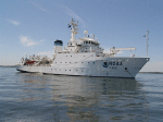
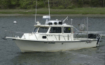
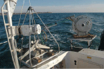
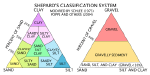
MethodsMBES data from NOAA hydrographic survey H12299 were collected on the NOAA ship Thomas Jefferson (fig. 3) and two survey launches, 3101 and 3102 (fig. 4), between September and November 2011. RESON SeaBat 7125 MBES systems, with frequencies of 400 kilohertz, were used to collect the bathymetric data (fig. 5). Sounding data are referenced to mean lower low water level and were corrected for tides by using National Water Level Observation Network stations in Newport, R.I.; New London, Connecticut; and Montauk, N.Y.; and a subordinate station in Orient Harbor, N.Y. Horizontal positioning was determined by using differential global positioning system (DGPS) equipment with corrections from U.S. Coast Guard DGPS stations in Sandy Hook, New Jersey, and Moriches, N.Y. MBES data were acquired by using Hypack 2009 software and converted to CARIS data format by NOAA. A swath bathymetric with associated statistical error (BASE) surface was created in CARIS by USGS and color, hill-shaded GeoTIFFs were exported. Additionally, a Bathymetric Attributed Grid (BAG) file was exported from CARIS; it was then imported into Fledermaus to make a digital terrain model and exported to ArcGIS as a raster grid. More detailed information on the data acquisition and processing for this survey is provided in National Oceanic and Atmospheric Administration (2011a, b) and in the metadata files in the Geographic Information System (GIS) Data Catalog section of this report. Sediment samples, bottom video, and still photographs were collected aboard the USGS research vessel (RV) Rafael (fig. 6) during cruise 2013-005-FA in June 2013. The small Seabed Observation and Sampling System (SEABOSS; fig. 7), a modified Van Veen grab sampler with attached still and video cameras, collected video along a transect of the sea floor as it drifted for several minutes at each station while the operator took a sediment sample and bottom photographs. Sediment samples were generally taken at the end of the transect at each station; however, nine stations do not have samples, because the sea floor was either too coarse or the seas were too rough for sampling. Most samples were collected from the top two centimeters (cm) of the sea floor and they were all analyzed in the USGS Woods Hole Coastal and Marine Science Center’s Sediment Lab according to the methods of Poppe and others (2005). The coarse fractions (sand and gravel; diameters equal to or greater than 0.0625 millimeters [mm]) of samples were sieved and the fine fractions (silt and clay; diameters less than 0.0625 mm) were analyzed by using a Beckman Coulter Multisizer 3. Gravel-sized shells were removed from the samples because they are not generally considered to be representative of the sedimentary environment; shells often form in situ and, hydraulically, they do not behave in the same manner as similarly sized sediment. Sediment descriptions are based on the modified nomenclature of Wentworth (1922; fig. 8) and modified size classifications of Shepard (1954; fig 9). Several minutes of video and 2 to 8 bottom photographs were taken at each station. Photographs were taken with a Canon PowerShot G12 from a height ideally of about 60 cm above the sea floor (lasers were set to align when the camera was at the targeted height), which resulted in images showing 30-cm to 1-meter (m) widths of the sea floor. Images of the still photographs can be seen in the Bottom Photography section of this report and full-resolution photographs and location data are available in the Geographic Information System Data Catalog section of this report. Bottom video can be obtained from the Data Library at the USGS Woods Hole Coastal and Marine Science Center, Woods Hole, Massachusetts. Interpretations in this report are based on MBES, sediment, and photographic data. Bedforms are characterized by their morphology and height. Sand waves are higher than 1 m, megaripples are 0.2 to 1 m high, and ripples are less than 0.2 m (Ashley, 1990). Interpreted sedimentary environments follow the scheme of Knebel and Poppe (2000). Bathymetric data are not to be used for navigation. |

![]() U.S. Department of the Interior |
U.S. Geological Survey
U.S. Department of the Interior |
U.S. Geological Survey
URL: http://pubsdata.usgs.gov/pubs/of/2014/1160/html/ofr2014-1160-methods.html
Page Contact Information: GS Pubs Web Contact
Page Last Modified: Wednesday, 07-Dec-2016 19:37:54 EST