FISC - St. Petersburg
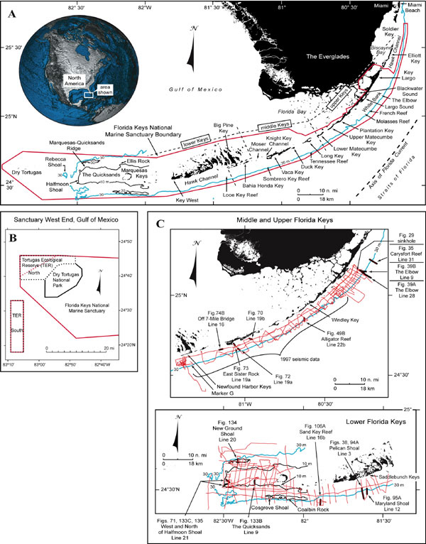
Figure 6. (A) Index map of south Florida and the Florida Keys (modified from Lidz et al., 2003). Dashed lines delineate lower, middle, and upper Keys. Note major tidal passes are in the middle Keys. The 30-m depth contour (blue line) marks the shelf margin, which lies within the Florida Keys National Marine Sanctuary boundary (red line). (B) Index map of west end of the Sanctuary shows the Tortugas Ecological Reserve North and South areas that became part of the FKNMS in July 2001. The FKNMS now has two boundaries. (C) Index map shows location of USGS seismic tracklines (red) and those portions selected (bold black) for illustration with their figure numbers. Shelf margin is in blue. A red "dot" of heavy seismic coverage at the northeast end denotes location of a sinkhole (Shinn et al., 1996). Contours are in meters.
|
Can't see the printable PDF version? Get the free Adobe Acrobat® Reader. |

![]() U.S. Department of the Interior |
U.S. Geological Survey
U.S. Department of the Interior |
U.S. Geological Survey
URL: [disc] /pubs/pp/2007/1751/professional-paper/figures/fig6.html
Page Contact Information: Feedback
Page Last Modified: December 01, 2016 @ 04:11 PM (JSS)
