FISC - St. Petersburg
|
Organization of Report
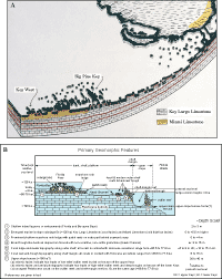
Overall Setting and Environment: Bedrock on the south Florida shelf is porous Pleistocene limestone (Fig. 21A, 21B). The 125 ka Key Largo Limestone (coral reef) and Miami Limestone (oolite) form the Florida Keys and are capped by Holocene soilstone crust (Fig. 7A, 7B). The keys are located ~5 to 7 km landward of an 80-ka coral reef that forms the shelf margin. Direction of prevailing energy (winds and waves) is from the southeast. In the upper Keys, the direction is therefore onshore or landward. In the lower Keys, the direction is tangential to the curved coastline. The marine environment off the upper Keys is considered to be restricted, or one in which circulation and current energy are low compared to conditions in open-marine environments (e.g., Ginsburg, 1956; Enos, 1977). A restricted environment off Key Largo is due in part to a lack of natural tidal creeks through the elongate island and thus limited tidal flushing (Fig. 20B; see Summary Illustration map). Therefore, sediments on the upper Keys shelf are lime-mud-bearing carbonate sands owing to lack of winnowing or removal of fine-grained material.
The environment off the middle and lower Keys exhibits a more open-marine setting. Tidal passes are numerous and wide (Fig. 20B, 20C). Water is deeper with a nearshore westward flow and diurnal tidal exchange from Florida Bay and the Gulf of Mexico. A Gulf-to-Atlantic slope in sea level exists, providing a net southward flow of surface water from the southwest Florida shelf toward the reef tract off the middle Keys (Smith, 1994, 1998). Offshore currents are strong. Fine-grained sediments are resuspended in the water column by winter and summer storms and are transported off the shelf, leaving coarser-grained material on the middle and lower Keys shelf (e.g., Lidz et al., 1985; Incze, 1998). Reefs of the Florida Keys are generally considered to be in a marginal reef environment (e.g., Jaap, 1984), in that water quality and temperature are not always optimal for coral growth. Coral reefs require clear, warm, low-nutrient waters with normal oceanic salinity (salt content) to survive. Reefs off the middle Keys are those most highly impacted by tidal influx of waters from Florida Bay and the Gulf of Mexico. Florida Bay waters are high in nutrient content from their being shallow (generally 2-3 m deep, Davies, 1980) and close to the mainland. Sediments in the bay are primarily fine-grained lime muds that often become suspended by high winds spawned by winter cold fronts or summer storms. Resultant turbidity can reach the offshore reefs. Bay waters are variable in salinity owing to mainland freshwater runoff during heavy rainfalls. Because of limited circulation, bay waters also become abnormally hot during the summer (Glynn, 1984) and abnormally cold during winter months (Roberts et al., 1982). Corals become stressed at temperatures higher than 33°C (91°F; Shinn, 1966) and lower than 15°C (59°F; Mayer, 1914). If temperature extremes do not reverse quickly (within hours), coral mortality is the likely result. All of these factors adversely affect corals. |

![]() U.S. Department of the Interior |
U.S. Geological Survey
U.S. Department of the Interior |
U.S. Geological Survey
URL: [disc] /pubs/pp/2007/1751/professional-paper/setting.html
Page Contact Information: Feedback
Page Last Modified: December 01, 2016 @ 04:12 PM (JSS)