FISC - St. Petersburg
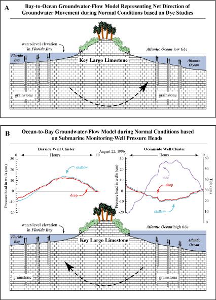
Figure 25. Conceptual models show bay-to-ocean groundwater flow during a falling and rising ocean tide (from Reich et al., 2002). (A) Net flow direction is seaward in the upper Keys approximately two-thirds of the time. (B) Graph shows pressure head in underwater monitoring wells on both sides of Key Largo during a rising and falling ocean tide. Corresponding conceptual model shows ocean-to-bay groundwater flow that occurs approximately one-third of the time. Pressure head at both well clusters was measured with an underwater manometer (Reich, 1996). Tidal fluctuation in Florida Bay was 3 cm over the 10-hour observation period. Arrows above wells indicate direction water would flow if well caps were removed. Models are not to scale.
|
Can't see the printable PDF version? Get the free Adobe Acrobat® Reader. |

![]() U.S. Department of the Interior |
U.S. Geological Survey
U.S. Department of the Interior |
U.S. Geological Survey
URL: [disc] /pubs/pp/2007/1751/professional-paper/tile1/figures/fig25.html
Page Contact Information: Feedback
Page Last Modified: December 01, 2016 @ 04:12 PM (JSS)
