FISC - St. Petersburg
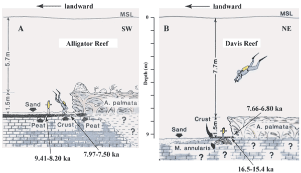
Figure 51. Sketches show locations of soilstone crust relative to present sea level and proximity to coral reefs at (A) Alligator and (B) Davis Reefs in the upper Keys (modified from Robbin, 1981). Davis Reef is located ~11 km northeast of Alligator Reef (Figs. 42B, 48B, 49A). Shelf-wide, bedrock in general is several meters deeper off the lower than upper Keys (e.g., Enos, 1977; Multer et al., 2002; Lidz et al., 2003). Although Alligator and Davis Reefs are relatively close, the Davis sample site is deeper than the Alligator site due to local irregularities in the bedrock surface. Such irregularities are typical shelf-wide. Ages on the figure have been converted from calendar years before present to ka for brevity. (A) Corrected 14C age range (7.97-7.50 ka, Table 3) for soilstone crust at Alligator Reef indicates that reef growth before ~7.5 ka would not have been possible due to subaerial conditions. An older age range (9.41-8.20 ka , two samples, Table 3) for adjacent mangrove peat indicates the peat was developing in a moisture-laden depression at the Alligator site before crust began to accumulate on higher adjoining topography. (B) Corrected 14C age range (16.5-15.4 ka, Table 3) for the top 2 cm of crust at the deeper Davis Reef site is consistent with submergence of the deeper site during crust formation at Alligator Reef. The corrected 14C age range for coral at the Davis site (7.66-6.80 ka, Table 4) indicates that corals at the Alligator site are probably younger than 6.8 ka due to later flooding of higher-elevation bedrock at Alligator Reef.
|
Can't see the printable PDF version? Get the free Adobe Acrobat® Reader. |

![]() U.S. Department of the Interior |
U.S. Geological Survey
U.S. Department of the Interior |
U.S. Geological Survey
URL: [disc] /pubs/pp/2007/1751/professional-paper/tile2/figures/fig51.html
Page Contact Information: Feedback
Page Last Modified: December 01, 2016 @ 04:13 PM (JSS)
