FISC - St. Petersburg
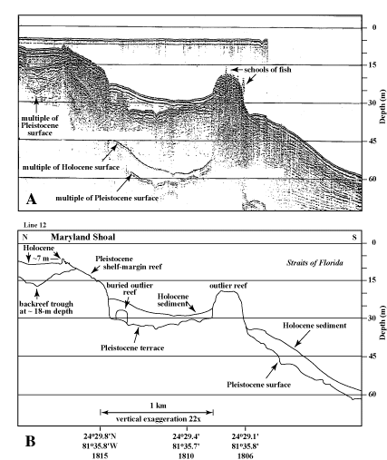
Figure 95. (A) Seismic-reflection profile obtained in 1989 and (B) interpretation show shelf margin at Maryland Shoal (lower Keys, Figs. 86C, 87B, 91B) and a single outlier reef at the outer edge of the upper-slope terrace. Note the jaggedness of Holocene corals at the crest of the shelf-edge reef. Holocene sediments have buried a small outlier reef near the base of the shelf-edge reef. The combination of location at the seaward terrace edge, presence of a single outlier at Maryland Shoal and at Eastern Sambo (Fig. 89, lines 4 and 2), and the smooth-mound reflection at Pelican Shoal is good seismic evidence that the mound may be a cemented dune ridge. However, coring the mound is the only way to verify this interpretation. Cemented dune ridges are believed to underlie the outlier reefs margin-wide (Lidz et al., 1997a, 2003). Latitude and longitude in degrees and decimal minutes based on GPS coordinates. Hours (military time) below coordinates serve as navigational correlation points along seismic line.
|
Can't see the printable PDF version? Get the free Adobe Acrobat® Reader. |

![]() U.S. Department of the Interior |
U.S. Geological Survey
U.S. Department of the Interior |
U.S. Geological Survey
URL: [disc] /pubs/pp/2007/1751/professional-paper/tile6/figures/fig95.html
Page Contact Information: Feedback
Page Last Modified: December 01, 2016 @ 04:14 PM (JSS)
