USGS - science for a changing world

FISC - St. Petersburg

Coastal & Marine Geology Program > Center for Coastal & Watershed Studies > Professional Paper 1751

Systematic Mapping of Bedrock and Habitats along the Florida Reef Tract—Central Key Largo to Halfmoon Shoal (Gulf of Mexico)

USGS Professional Paper 1751

by Barbara H. Lidz, Christopher D. Reich, and Eugene A. Shinn

Introduction:
Table of Contents
Project Overview
Project Objective
Geologic Setting
Primary Datasets
Primary Products - Overview Maps & Evolution Overview:
Bedrock Surface map.
Introduction
Depth to Pleistocene Bedrock Surface
Reef & Sediment Thickness
Benthic Ecosystems & Environments
Sedimentary Grains in 1989
Summary Illustration Index Map
Evolution Overview
Tile-by-Tile Analysis
Satellite image of the Florida Keys showing location of tiles.
Organization of Report
Tiles: 1, 2, 3, 4,
5, 6, 7/8, 9/10,
11
Summary
Acknowledg-
ments
References
Disclaimer
Related
Publications

Tile 6

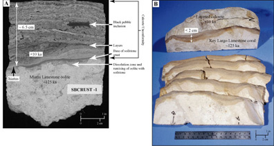
Saddlebunch Keys: The Saddlebunch Keys occupy approximately the middle part of the lower Keys (Fig. 86C). Coring at Saddlebunch Keys has shown that the underlying oolite of the Miami Limestone is encrusted with several inches of calcrete, some of the thickest such crust in the keys (Fig. 93A, 93B). Oolite is less permeable than the skeletal coral reef that forms the Key Largo Limestone of the middle and upper Keys (Vacher et al., 1992). When newly exposed to air during a time of lower sea level, the oolite would have retained rainfall moisture longer than the porous reef. Prolonged periods of moisture coupled with lower porosity produced thicker layers of calcrete.

drill core and rock sample
Figure 93. (A) Slabbed drill core shows thick, reddish-brown layered soilstone crust or calcrete that developed as an unconformity on top of the Miami Limestone oolite. The core was taken in the Saddlebunch Keys (lower Keys, Fig. 86C). (B) Rock sample shows the same calcrete unconformity that developed on top of the Key Largo Limestone coral reef. The sample came from the Key Largo Waterway (also called Adams Cut), located between Blackwater and Largo Sounds on Key Largo (upper Keys, Fig. 86B). Note the crust on the oolite (A) is much thicker than the crust on the coral (B). A difference in porosity between the two limestones is thought to cause the difference in thickness between the calcrete accretions. Less porous than the coral reef, the oolite retained rainfall moisture longer, allowing longer periods of layered-calcrete buildup. Reddish and brownish layers in both calcretes represent periods of influx of non-carbonate minerals on African dust. The hiatus or gap in these rock records represents an interval of more than 115 ka during which no marine deposition occurred. [larger version]

Coastal & Marine Geology Program > Center for Coastal & Watershed Studies > Professional Paper 1751

Accessibility FOIA Privacy Policies and Notices

Take Pride in America logo USA.gov logo U.S. Department of the Interior | U.S. Geological Survey
URL: [disc] /pubs/pp/2007/1751/professional-paper/tile6/saddle-bunch-keys.html
Page Contact Information: Feedback
Page Last Modified: December 01, 2016 @ 04:14 PM (JSS)