
CONTRIBUTIONS TO THE GEOLOGY OF KENTUCKY
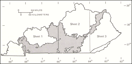
FIGURE 6.--Area of outcrop of Mississippian strata in Kentucky (shaded). |
The Sunbury Shale is remarkably uniform in thickness throughout its area of distribution. The Bedford Shale and coarser elastic units, the Berea Sandstone and the Farmers Member, are thickest at the northern end of their outcrop belts, along the Ohio River in Lewis County, and thin to pinch-outs southward and westward. The sandstone beds of the Farmers Member range from a few inches to several feet in thickness and are thickest near the base. The sandstone beds progressively thin upward, and intervening shale beds thicken correspondingly. These sandstone beds are interpreted as turbidite deposits on the basis of morphology and internal features (Moore and Clarke, 1970). Abrupt eastward pinch-outs of these beds along the Ohio River in northeastern Lewis County may represent a proximal margin of the turbidite sequence (see diagram, top of sheet 3).
The rocks of this map unit are of Early Mississippian age except for the lower few feet of the Bedford Shale, which are of Late Devonian age (de Witt, 1970). The Farmers Member of the Borden Formation and the Berea Sandstone form steep slopes where thick; the Sunbury and Bedford Shales form low slopes covered by thin soil and locally by sandstone blocks weathered from the Farmers.
Wildie, Nada, Halls Gap, Holtsclaw Sittstone, Cowbell, Nancy, Kenwood Siltstone, and New Providence Shale Members of the Borden Formation (Mb).--This sequence of siltstone and shale becomes coarser grained upward from the shale of the New Providence Shale Member and the Nancy Member at the base to the siltstone of the Cowbell, Wildie, and Halls Gap Members and the Holtsclaw Siltstone Member. The transition from finer to coarser grained is gradational over the entire sequence, and in most cases boundaries between members can be only approximately located. The lower contact with black shale of the Chattanooga, New Albany, or Sunbury Shales or sandstone of the Farmers Member of the Borden Formation is generally sharp.
Fine-grained detrital rocks of the Borden Formation and equivalent units are widespread in the east-central United States. In Kentucky they crop out from the northeastern corner of the State, along the Ohio River where the formation is about 500 ft thick, southwestward and westward to Somerset and Louisville. These rocks thin abruptly and may pinch out locally between the Chattanooga Shale and the Fort Payne Formation along a narrow zone that extends from just west of Louisville southeastward to Somerset (see "Generalized Stratigraphic Cross Section of the Borden and Fort Payne Formations," top of sheet 1 of the geologic map). This zone, described as a Borden deltaic front by Peterson and Kepferle (1970), marks the southwesternmost advance of most of the detrital rocks of the Borden Formation. A thin, green shale about 1 to 2 ft thick is present at the base of the Fort Payne Formation throughout a large portion of south-central Kentucky; it may be a distal extension of the New Providence Shale Member of the Borden Formation. This shale is mapped with the Fort Payne. Borden detrital units extend beneath younger rocks of the Cumberland Plateau and are present along and south of the Pine Mountain overthrust fault as shale, siltstone, and sandstone of the Grainger Formation. Correlative strata are recognized in Ohio as part of the Logan Formation, and in Indiana and Illinois, where they constitute the Borden Formation of that area.
Lateral and vertical facies changes characterize the fine-grained detrital rocks of the Borden Formation, as shown in the columnar sections and in several stratigraphic diagrams on the geologic map. In ascending order, the northeasternmost portion of the Borden is composed of a clay shale and silty shale (Nancy Member) overlain by a siltstone (Cowbell Member) and thin red and green shale containing a few thin lenses of limestone (Nada Member). The overlying dolomite of the Renfro Member is mapped with these rocks only where it is too thin to be shown separately (sheet 2). To the southwest, near the center of the State, the Nancy Member becomes more shaly, the Cowbell Member thins, and the Nada Member thickens slightly.
In the vicinity of Mount Vernon, in Rockcastle County, several major changes occur (see generalized stratigraphic diagram, top of sheet 1). The lower part of the Nancy Member becomes a relatively pure clay shale, the New Providence Shale Member. The Cowbell Member splits into two distinct siltstone bodies that descend stratigraphically toward the southwest and pinch out within the Nancy Member near Interstate Highway 1-75 (Weir and others, 1966). Siltstone layers in the middle of the Nada Member thicken to the west and become the Halls Gap Member. The Nada is thus split into two parts: the upper part becomes the Wildie Member, which pinches out to the west, and the lower part becomes the uppermost Nancy Member.
The coarsening-upward succession over most of the central portion of the State is made up of the New
Providence Shale Member, the Nancy Member, and the Halls Gap Member. This triad extends westward to
the area near Shepherdsville, in Bullitt County, where the Halls Gap Member becomes indistinguishable
from the Nancy Member and is no longer mappable. Northeast of Shepardsville, in the Louisville area, two
siltstone tongues, the Kenwood Siltstone Member, at the top of the New Providence Shale Member, and the
Holtsclaw Siltstone Member, above the Nancy Member, thin and descend southeastward in the section as
foreset beds along the Borden prodelta front (Kepferle, 1971, 1977).
The rocks of this map unit are entirely of Early Mississippian age.
Renfro and Muldraugh Members of the Borden Formation and Fort Payne Formation (Mbf).--Rocks included in this map unit overlie Lower Mississippian detrital rocks and record a major shift in sedimentary environments from basinal and deltaic to shallow-marine carbonate near the end of Early Mississippian time. The Muldraugh and Renfro Members are uppermost units of the Borden Formation, whereas the Fort Payne Formation overlies the Borden Formation along the delta front and the Chattanooga Shale elsewhere (see diagrams at top of sheet 1). The lower contact of unit Mbf is marked by a thin layer of glauconite and phosphatic nodules, which indicate a hiatus in sedimentation (Peterson and Kepferle, 1970). The upper contact is gradational and in places intertonguing with Lower and Upper Mississippian limestone, dolomite, and shale. In northeastern Kentucky, where this map unit (here the Renfro Member) is too thin to show separately, it is included with the detrital members of the Borden Formation. The Fort Payne and Muldraugh are Early Mississippian in age and the Renfro is Early and Late Mississippian. Rocks forming this map unit commonly have many small caverns and sinkholes and are overlain by cherty soils.
The Fort Payne Formation and the Muldraugh and Renfro Members of the Borden Formation crop out over much of south-central Kentucky. The Fort Payne Formation occurs in the subsurface below most of the western Kentucky coal field and a small portion of the Cumberland Plateau along the Tennessee border. Outcrops of the Fort Payne Formation are also present along the Tennessee and Cumberland Rivers in western Kentucky, and the Fort Payne Chert is recognized along the Pine Mountain overthrust in Whitley and Bell Counties, where it is mapped with other Mississippian Formations. The Muldraugh Member occurs in the subsurface along the Ohio River in Meade County and along the Kentucky-Tennessee line in McCreary and Whitley Counties. The Renfro Member occurs in the subsurface in eastern Kentucky.
The Fort Payne Formation is as much as 660 ft thick in south-central and western Kentucky, where it overlies the Chattanooga Shale. Gray to black dolomitic siltstone and cherty, dolomitic limestone of the Fort Payne were deposited as basin fill adjacent to and southeast of the Borden deltaic sediments. The Fort Payne thins northward to 150 to 300 ft in central Kentucky, where it is more silty, shaly, and dolomitic and less siliceous. Two northwest-trending carbonate bodies, composed primarily of crinoid debris, occur within the Fort Payne (map units "Is" on sheet 2, including the Cane Valley Limestone Member of Fort Payne Formation as shown on the "Generalized Stratigraphic Cross Section of the Borden and Fort Payne Formations" at the top of sheet 1). These crossbedded crinoidal limestones drop stratigraphically to the southwest. North and east of these limestones a calcareous sandstone body, the Knifley Sandstone Member of the Fort Payne Formation, trends subparallel to the limestone bodies and also drops in the section to the southwest (shown as map unit "k" on sheet 2, and in the "Generalized Stratigraphic Cross Section" on sheet 1). The Knifley Sandstone and Cane Valley Limestone Members occur at or just southwest of the Borden prodelta front, where the Fort Payne Formation thins as it onlaps the Borden elastics (see map and diagram).
The Muldraugh Member of the Borden Formation also overlies Borden detrital rocks; it is considered to be a thinned lateral equivalent of the Fort Payne Formation. The Muldraugh Member, like the Fort Payne, is a silty and cherty dolomite, but it contains smaller bodies of crinoidal limestone and some silty shale. The unit thins slightly to the northeast, and the underlying deltaic sediments thicken reciprocally (in central Kentucky). Near Mount Vernon, in Rockcastle County, the Muldraugh Member is very dolomitic and cannot be distinguished from the overlying units, the Salem and Warsaw Limestones and the lower part of the St. Louis Limestone, which have also thinned in this direction. Sandy and silty dolomite and limestone of these three units have been combined as the Renfro Member of the Borden Formation, which thus includes the interval from the top of the Wildie and Nada Members of the Borden Formation to the base of the Newman Limestone (see generalized stratigraphic diagram, sheet 1). The Renfro Member thins northeastward from 120 to less than 3 ft, where it is too thin to show as a separate map unit. The Renfro Member is therefore combined with the underlying detrital members of the Borden Formation from Jackson County to northeasternmost Kentucky. On a few geologic quadrangle maps the Renfro, where very thin, is combined with the overlying Newman Limestone.
The Renfro Member has recently been reassigned as the lowermost member of the newly established Slade
Formation (Ettensohn and others, 1984). The Slade is a carbonate unit and replaces the carbonate part of the
Newman Limestone along the Pottsville Escarpment in northeastern and east and south-central Kentucky.
The Slade is coextensive with the Renfro Member.
Warsaw Limestone (Mw).--The Warsaw Limestone of Trigg and Lyon Counties and adjacent areas of western
Kentucky is a light-gray, coarse-grained, largely crinoidal-bryozoan limestone, about 150-300 ft thick, which
crops out mainly along the Cumberland and Tennessee Rivers. It overlies the Fort Payne Formation, is
overlain by the Salem Limestone, and is correlated with the Ullin and Harrodsburg Limestones of southern
Illinois and west-central Kentucky (Pryor and Sable, 1974; Rice, Sable, and others, 1979). It may be
equivalent to the lower part of the Salem and Warsaw Limestones of south-central Kentucky (see
"Generalized Correlation Diagram of Meramee Rocks," sheet 1).
The Warsaw Limestone in western Kentucky is commonly cherty and argillaceous at its base; this inner part is similar to but coarser grained than limestone of the Fort Payne Formation (Hays, 1964). The remainder of the Warsaw Limestone is composed of crossbedded, skeletal limestone with scattered chert nodules and abundant fossils. It is the basal Meramecian unit of western Kentucky and contains the brachiopod Warsawia (formerly Spirifer) lateralis, the bryozoan Fenestrella, and spines of the echinoids Echinocrinus and Melonechinus. The Warsaw Limestone of western Kentucky was deposited on a shallow-marine shelf and in troughs within this shelf.
The Warsaw, like most of the Upper Mississippian limestones of western Kentucky, is poorly exposed and is identified principally by a thick, reddish-brown, cherty soil.
Salem, Warsaw, and Harrodsburg Limestones (Msh).--These rocks, which crop out from Simpson and Allen Counties in west-central Kentucky along the Tennessee border northward to Jefferson County and eastward to Pulaski and Rockcastle Counties, generally are 80 to 160 ft thick but thin to less than 40 ft to the east. They include units equivalent to the Salem and Warsaw Limestones of western Kentucky and the Warsaw Limestone of Tennessee and are equivalent to the Salem Limestone and the upper part of the Harrodsburg Limestone of Indiana (Pryor and Sable, 1974; Rice, Sable, and others, 1979). In central Kentucky, east of Rockcastle County, lateral equivalents are included in the Renfro Member of the Borden Formation (see generalized stratigraphic diagram, top of sheet 1).
The Salem and Warsaw Limestones and the Harrodsburg Limestone are the southern and northern units, respectively, of the lowermost Upper Mississippian strata east of the western Kentucky coal field (see generalized stratigraphic cross section, top of sheet 1). (The Salem and Warsaw Limestones are treated as a single stratigraphic unit where the Harrodsburg is not present). This interval everywhere includes a small portion of the Lower Mississippian at the base. The Salem and Warsaw (combined) occur in Kentucky south of Taylor, Casey, and Lincoln Counties and in the subsurface of the southern part of the western Kentucky coal field. The Salem Limestone and the Harrodsburg Limestone occur north of these counties and in the northern part of the subsurface of the western Kentucky coal field (Sable and others, 1966) and continue into southern Indiana. The boundary between these interfingering northern and southern units is arbitrarily drawn. To the east in Lincoln and Pulaski Counties, the lower part of the Salem and Warsaw Limestones interfingers with the Science Hill Sandstone Member of the Warsaw (Lewis and Taylor, 1979).
The Harrodsburg and Warsaw Limestones record the shallowing that followed the basin-filling Fort Payne and Borden Formations. The Harrodsburg Limestone is a light-gray, crossbedded, cherty skeletal limestone containing numerous fossils, including the brachiopods Warsawia lateralis and Marginirugus magnus. The Harrodsburg Limestone normally is 40-70 ft thick and slightly dolomitic in the lower part, but it can be distinguished from the underlying Muldraugh Member of the Borden Formation where it overlies those darker dolomitic siltstones and from the darker shales and limestones of the overlying Salem Limestone. The Harrodsburg Limestone resembles the limestone bodies in the Fort Payne and Borden Formations, but it has more calcite cement and less argillaceous matrix than those deeper water, slope-deposited crinoidal limestones. The Harrodsburg thins and disappears below the Science Hill Sandstone Member in central Kentucky and into the basal portion of the Salem and Warsaw Limestones in west-central Kentucky.
The Warsaw Limestone in west and south-central Kentucky is a mixture of argillaceous, crossbedded skeletal limestone and dark, dolomitic siltstone and shale. It contains the brachiopod Warsawia lateralis and was deposited in shallow marine water that was more turbid than that of the Harrodsburg Limestone. In west and south-central Kentucky, the Warsaw Limestone cannot everywhere be differentiated from the Salem Limestone and is, therefore, combined with the Salem into a single map unit, the Salem and Warsaw Limestones. This combined unit consists of argillaceous limestone and limy shale at the top and the base, and dolomitic siltstone and shale in the middle.
The Salem Limestone, where it overlies the Harrodsburg Limestone or can be differentiated from the Warsaw Limestone in west-central Kentucky, is 80 to 140 ft thick and is composed of dark, dolomitic siltstone and shale with minor bodies of skeletal limestone in the lower part, overlain by argillaceous, crossbedded limestone in the upper part. The Salem contains abundant marine fossils, notably bryozoan fronds, brachiopods, crinoids and blastoids, horn corals, including Hapsiphyllum (locally abundant), and endothyrid foraminifers. It represents shallow-marine and perhaps lagoonal environments of the Upper Mississippian shelf.
In Lincoln and Pulaski Counties, the lower part of the Salem and Warsaw Limestones is represented by 40 ft of fossiliferous, crossbedded quartzose sandstone of the Science Hill Sandstone Member of the Warsaw, which is overlain by about 40 ft of argillaceous limestone and dolomite referred to the Salem Limestone (Lewis and Taylor, 1979). The sandstone thins to the north and east and is recognizable as a 2-in-thick layer of sandy, pebbly limestone at Interstate Highway 1-75. The argillaceous dolomite above the pebbly limestone is indistinguishable from that of the Borden Formation below; these rocks, along with the dolomitic lower portion of the St. Louis Limestone, are included in the Renfro Member of the Borden formation and are mapped as a single unit (see generalized stratigraphic diagram, top of sheet I). The sandstone was probably deposited as a submarine sand bar on the shallow-water shelf, while to the north of the bar canner and perhaps shallower water existed (Lewis and Taylor, 1979).
Outcrops of the Harrodsburg Limestone are rare, and it forms thick reddish-brown soils and minor karst
features. The less pure limestone, siltstones, and shales of the Salem and Warsaw develop a thinner,
brownish soil and are more commonly exposed.
Ste. Genevieve and St. Louis Limestones (Mgl).These limestones constitute the bulk of the strata of
Meramecian age and underlie broad karst plains in western, west-central and south-central Kentucky. In
western Kentucky, this map unit includes the Salem Limestone of Illinois and Missouri (Pryor and Sable,
1974; Rice, Sable, and others, 1979) at the base. The St. Louis and Ste. Genevieve extend eastward in outcrop
around the western Kentucky coal field and correlate with the Ste. Genevieve and St. Louis Limestones in
Indiana (Pryor and Sable, 1974). In the outcrop belt east of Lake Cumberland the Ste. Genevieve Limestone
is included as the lower member of the Monteagle Limestone, while northeast of Pulaski County the lower
part of the St. Louis Limestone is included in the Renfro Member of the Borden Formation. In east-central
and northeastern Kentucky, thin, discontinuous limestones are referred to as the St. Louis and Ste.
Genevieve Limestone Members of the Newman Limestone. These units have been reassigned as the St.
Louis and Ste. Genevieve Members of the newly named Slade Formation, which replaces the name
"Newman Limestone" along the Pottsville Escarpment in eastern Kentucky (Ettensohn and others, 1984).
The St. Louis Limestone of western Kentucky is about 500 ft thick and is divided into two informal members separated by a zone of abundant chert. It is a very fine-grained, somewhat cherty, argillaceous and dolomitic limestone with some beds of skeletal limestone, formed on a shallow-marine shelf, and is characterized by the corals Acrocyathus proliferus and A. floriformis (Lithostrotion proliferum and Lithostrotionella castelnaui of earlier reports) in the lower part. The lower contact is rarely exposed, and the underlying Salem Limestone, part of which is lithologically similar to the St. Louis, is included with this map unit in western Kentucky.
The Salem Limestone in this area is about 120 ft thick and is composed of dark-gray, crossbedded skeletal limestone and fine-grained argillaceous limestone with some oolitic limestone at the top.
A 10- to 20-ft-thick zone of extremely cherty limestone occurs near or at the top of the St. Louis Limestone in western Kentucky. The overlying Ste. Genevieve Limestone is from 190 to 320 ft thick and is divided into three members. The basal Fredonia Limestone Member, thickest of the three, is a very light gray, crossbedded and massive, oolitic to skeletal limestone characterized by the crinoid Platycrinites. The overlying Rosiclaire Sandstone Member (equivalent to the Aux Vases Sandstone in Illinois) is composed of calcareous sandstone and shale, and the Levias Limestone Member (equivalent to the Levias Limestone Member of the Renault Limestone in Illinois) is an oolitic to skeletal limestone similar to the Fredonia. The top of the Ste. Genevieve Limestone is placed below the sandy and silty fine-grained limestone of the Renault Limestone. The rocks of the Ste. Genevieve formed as sandbars and shoals on a shallow-marine shelf which supported an abundant fauna.
Near the boundary between Trigg and Christian Counties, the contact between Ste. Genevieve and St. Louis Limestones differs by about 275 ft stratigraphically, as indicated in the stratigraphic diagram of Meramecian rocks (left side of sheet 1). To the east, the top of the St. Louis is placed above the uppermost beds containing abundant acrocyathid corals (Ulrich and Klemic, 1966). This zone occurs near the cherry limestones which to the west separate the upper and lower parts of the St. Louis. The expanded Ste. Genevieve is as much as 500 ft thick, while the restricted St. Louis is about 400 ft thick.
The Ste. Genevieve and St. Louis Limestones extend eastward around the western Kentucky coal field with little change in character, although no members of the Ste. Genevieve are recognized. The contact with the Salem and Warsaw Limestones is placed at the base of fine-grained limestone of the St. Louis, while the top of the Ste. Genevieve Limestone is placed at the highest occurrence of the crinoid Platycrinites penicillus. The Ste. Genevieve and St. Louis Limestones are combined in geologic quadrangle maps north of Hart County (Moore, 1972) (see generalized correlation diagram, sheet 1). The Lost River Chert of Elrod (1899), used locally as an informal map unit, is a conspicuous zone of highly fossiliferous, blocky chert about 10 to 20 ft above the uppermost acrocyathid corals.
In south-central Kentucky, the Ste. Genevieve and St. Louis Limestones are thinner and are divided at a zone of a calcarenite-cemented chert "breccia" (conglomerate). The St. Louis Limestone includes 70 to 160 ft of very fine-grained limestone, dolomite, and fossiliferous siltstone. The overlying 30 to 90 ft of oolitic, skeletal limestone, designated the Ste. Genevieve Limestone Member of the Monteagle Limestone (Lewis, 1971), includes at the top a thin zone of indistinct silicified breccia, informally called the Bryantsville breccia of Patton (1949), near the uppermost occurrence of Platycrinites penicillus. The St. Louis and Ste. Genevieve thin to the northeast, owing partly to the incorporation of the lower dolomitic portion of the St. Louis Limestone into the Renfro Member of the Borden Formation and partly to an unconformity at the top of the St. Louis (see stratigraphic diagram, sheet 1).
The Ste. Genevieve and St. Louis Limestones underlie a broad karst plain covered by sinkholes and thick red soils and famed for the extensive Mammoth Cave-Flint Ridge cave system. The contacts and faults shown on geologic quadrangle maps were in many places based on chert residuum, subsurface data, or projections from other strata.
Rocks of Chester age, lower part (Mcl).--Overlying the Ste. Genevieve and St. Louis Limestones of western and west-central Kentucky is a thick sequence of limestones, sandstones, siltstones, and shales of Chester age, divided on the map into upper and lower parts (see "Generalized Correlation Diagram of Chester Rocks," sheet 1). The lower part includes the strata below the top of the Glen Dean Limestone. These rocks occur around the margin of the western Kentucky coal field but are not found east of Larue and Hart Counties. Rocks of lower Chester age are included in the Monteagle Limestone, Hartselle Formation, Bangor Limestone, and Newman Limestone of eastern Kentucky.
Western Kentucky and southern Illinois are the type areas for rocks of early Chester age in the United States. The section west of the western Kentucky coal field is divided into seven formations, in ascending order: Renault Limestone, Bethel Sandstone, Paint Creek Limestone, Cypress Sandstone, Golconda Formation, Hardinsburg Sandstone, and Glen Dean Limestone (see generalized correlation diagram, left side of sheet 1). This sequence of alternating sandstones and limestones or shales is about 600 ft thick. The Renault Limestone consists of two fine-grained, argillaceous and sparsely oolitic limestone sequences, about 25 to 40 ft thick, separated by about 20 to 30 ft of greenish-gray, fossiliferous calcareous shale. The Renault is unconformably overlain by, and in places has been completely eroded below, the Bethel (Mooretown) Sandstone. This light-gray, fine-grained quartzarenite generally occurs as a 50-ft-thick unit but forms elongate channel fillings as much as 120 ft thick. It generally includes some conglomerate at the base and locally some coal beds and shale in the upper part. The Paint Creek Limestone, a variable sequence of impure fossiliferous limestones and shales, overlies the Bethel. Along the Ohio River west of the western Kentucky coal field, the Paint Creek is represented by about 10 ft of argillaceous sandstone (Trace, 1974b). South of this area, the formation thickens to about 100 ft and consists of a basal skeletal limestone, a middle unit of shale and sandstone, and an upper skeletal limestone (Rogers and Trace, 1976). These rocks are overlain by a variable thickness of fine-grained sandstone and silty shale of the Cypress Sandstone. Along the Ohio River west of the western Kentucky coal field, the Cypress is as much as 230 ft thick (Trace, 1974b), but it thins southward to about 10 ft (Rogers and Trace, 1976). The Golconda Formation is everywhere about 100 ft thick and consists of sandstone, limestone, and siltstone, each interbedded with dark-gray, calcareous shale. The upper and lower portions contain much skeletal limestone, while the middle is predominantly fine-grained, calcareous sandstone and siltstone. The Hardinsburg Sandstone, which consists of interbedded and intertonguing fine-grained, crossbedded sandstone and sandy shale, thins from more than 100 ft along the Ohio River west of the western Kentucky coal field (Trace, 1974b) to about 50 ft in the south (Rogers and Trace, 1976). The contact between the Hardinsburg Sandstone and the overlying Glen Dean Limestone is one of the most easily recognizable and stratigraphically useful contacts in western Kentucky. The Glen Dean is a medium-gray, coarse-grained skeletal limestone with argillaceous limestone at the top and bottom of the unit. The upper contact is unconformably overlain in places by channel sandstones of the Tar Springs Sandstone. In western Kentucky, the Glen Dean is in most places 40 to 95 ft thick.
Eastward along the outcrop belt south of the western Kentucky coal field, the lower rocks of Chester age change in appearance and nomenclature (see Chester correlation diagram, sheet 1). The sandstones and shales of the Bethel Sandstone, Paint Creek Limestone, and Cypress Sandstone thin, so that the interval between the Ste. Genevieve Limestone and the middle of the Golconda Formation consists predominantly of fine- and medium-grained, skeletal and argillaceous limestones with some oolitic limestone. These limestones are given the name Girkin Limestone. The upper contact is placed at the base of a thick sandstone, the Big Clifty Sandstone Member of the Golconda Formation, which here is the lower member of the Golconda. This sandstone is about 40 to 120 ft thick and is composed of planar-bedded and crossbedded sandstones and minor shale, with siltstone, shale, and minor coal beds at the top. Above this unit are 10 to 45 ft of fine-grained, skeletal limestone referred to the Haney Limestone Member of the Golconda Formation. The Hardinsburg Sandstone is here generally about 30 to 60 ft of crossbedded and planar-bedded sandstone. The Glen Dean Limestone in this area is as much as 80 ft of coarse-grained and argillaceous limestone.
On the eastern side the western Kentucky coal field, in Larue, Hardin, and Meade Counties, the limestones in the lower part of the lower Chester interval are separated by thin but distinctive sandstones and sl-.ales, which occur in the general stratigraphic positions of the Bethel Sandstone, Paint Creek Limestone, and Cypress Sandstone of western Kentucky (see correlation diagram on sheet 1). At the base, the Paoli and Beaver Bend Limestone, both consisting of skeletal and oolitic limestones, are separated by channel fill and sheetlike shales and sandstones of the Mooretown Formation (Peterson, 1964; Sable, 1964; Amos, 1977). The Paoli, Mooretown, and Beaver Bend correlate, respectively, with the Renault Limestone, Bethel Sandstone, and Paint Creek Limestone. The Paoli and the Beaver Bend are each about 40 ft thick. Over much of west central Kentucky the Mooretown Formation is thin or absent, but in western Hardin and eastern Meade Counties a channel sandstone as much as 340 ft thick was locally emplaced in the lower part of the Ste. Genevieve Limestone and occurs locally as slumped sandy material on the St. Louis Limestone (Swadley, 1963; Withington and Sable, 1969; Kepferle and Sable, 1977) (see generalized block diagram, sheet 1). This channel fill is shown on the State map as the unit "ss." The Sample Sandstone overlies the Beaver Bend and consists of about 15 ft of sandstone and calcareous shale; it is equivalent to the middle part of the Paint Creek Limestone. Above the Sample is the Reelsville Limestone, which is 20 to 50 ft of light-gray, fine grained, resistant skeletal limestone. A thin sandy and calcareous shale occurs above the Reelsville north of Hart County. This shale is presumed to be an extension of the Elwren Sandstone of Malott (1919) and to correlate with the Cypress Sandstone of western Kentucky. The top of this shale marks the base of the Beech Creek Limestone Member of the Golconda Formation, a very distinctive 10- to 20-ft-thick, brownish gray skeletal limestone with abundant productid brachiopods. The Beech Creek is the uppermost part of the Girkin Limestone where the Elwren Sandstone is absent. Above the Beech Creek are the Big Clifty Sandstone Member and the overlying Haney Limestone Member of the Golconda Formation, succeeded by the Hardinsburg Sandstone, in this region fine grained, and the Glen Dean Limestone.
The rocks of early Chester age were deposited on a shallow-marine shelf across western and west-central Kentucky. The normal shelf deposition of skeletal carbonates was periodically interrupted by deposition of deltaic and littoral sandstones and shales which prograded from the north and northeast. These terrigenous sediments are thickest along the Ohio River and thin southward to a featheredge.
The limestones are generally poorly exposed, forming low slopes covered with thick red soils with scattered chert and fossil fragments, although the Reelsville Limestone commonly forms a moderate slope with a bench at the top formed by the overlying shaly beds. The shales also form low, soil-covered slopes and are rarely exposed. The sandstones and some siltstones form steep cliffs and slopes and are generally well exposed. Thin, sandy soils form on these rocks. Benches covered by loose sand form at the tops of the sandstones cliffs, and blocks of sandstone commonly cover the slopes and obscure the lower contacts of the sandstone unit. Small areas of karst terrain form on the thicker limestones, but they are not as extensive as those on the Ste. Genevieve and St. Louis Limestones.
Rocks of Chester age, upper part (Mcu).-This unit, about 700 ft thick in the fluorspar district of western Kentucky, thins to the east and is locally absent on the eastern margins of the western Kentucky coal field because of pre-Pennsylvanian erosion and channeling. The fluorspar district of western Kentucky and southern Illinois is the type area for most of the formations that constitute the upper Chester rocks. Many of these formations become indistinguishable in central Kentucky and are mapped as the Buffalo Wallow or Leitchfield Formations (see generalized correlation diagram, sheet 1). These rocks are approximately equivalent to the Pennington Formation of south-central Kentucky and Tennessee.
Along the Ohio River in western Kentucky, the upper rocks of Chester age include the following formations, in ascending order: Tar Springs Sandstone, Vienna Limestone, Waltersburg Sandstone, Menard Limestone, Palestine Sandstone, Clore Limestone, Degonia Sandstone, Kinkaid Limestone, and Grove Church Shale. The top of this sequence of terrigenous and carbonate sedimentary rocks is an erosional unconformity below the Caseyville Formation of Pennsylvanian age. The base of this sequence is unconformable on the Glen Dean Limestone.
The Tar Springs Sandstone consists of about 100 ft of fine-grained, thin-bedded sandstone and silty shale containing siderite nodules. The Vienna Limestone is a distinctive cherty, skeletal limestone that is normally about 15 ft thick. Dark, fine-grained, carbonaceous sandstone and shale with siderite nodules make up the Waltersburg Sandstone, which is generally about 25 to 45 ft thick and resembles the upper part of the Tar Springs. The Menard Limestone is composed of several layers, 15 to 45 ft thick, of dark argillaceous skeletal limestone separated by somewhat thinner zones of calcareous, fossiliferous shale and siltstone. The Menard is commonly 100 to 140 ft thick and is overlain by 30 to 90 ft of sandstone, siltstone, and shale assigned to the Palestine Sandstone. The lower portion of the Palestine is predominantly fine-grained, calcareous sandstone, while the upper portion is carbonaceous and sideritic silty shale. The Clore Limestone resembles the interlayered limestone and shale of the Menard Limestone and is about 100 ft thick. The Degonia Sandstone is about 10 to 30 ft of dark, fine-grained sandstone, siltstone, shale, and minor amounts of limestone. The Kinkaid Limestone is about 160 ft thick and is divided into three informal members: a basal skeletal limestone member with numerous gastropods and the brachiopod Spirifer increbescens; a middle member of calcareous, fine-grained sandstone and silty shale overlain by skeletal and dolomitic limestone and succeeded by red and green shale; and an upper member of light-gray, cherty, very fossiliferous, skeletal limestone.
South of the western Kentucky coal field and to the east of Muhlenberg County, the upper rocks of Chester age are thinner and include more shale and siltstone than in the fluorspar district of western Kentucky. In this area, these rocks have been combined as the Leitchfield Formation (see correlation diagram, sheet 1), which is mostly shale and siltstone with minor sandstone and limestone. Pre-Pennsylvanian erosion has removed portions and, farther east, locally all of the Leitchfield.
In the northern part of west-central Kentucky, the Tar Springs Sandstone succeeds the Glen Dean Limestone. The overlying Mississippian rocks are mapped as the Buffalo Wallow Formation, which is composed of shales and siltstones with lesser sandstone and limestone beds. The most prominent limestones and sandstones have locally been mapped as members: the Vienna Limestone Member at the base, the Palestine Sandstone Member, and the Kinkaid Limestone Member at the top (see correlation diagram, sheet 1).
The upper part of the rocks of Chester age includes more terrigenous rocks than the lower part; this feature
is interpreted as indicating the progradation of deltaic and coastal sediments across the shelf from the north.
The limestone, shale, and siltstone of this map unit weather to form a thick soil cover and are rarely
exposed. The sandstones form steeper slopes than do the lower Chester rocks, and thinner, sandy soils with
numerous outcrops. Some faults in southwest-central Kentucky are overlapped by unfaulted Pennsylvanian
Caseyville Sandstone, indicating Late Mississippian or Early Pennsylvanian tectonic activity before
deposition of basal Pennsylvanian sediments.
Bangor Limestone, Hartselle Formation, and Kidder Limestone Member of Monteagle Limestone (Mbk).--These rocks
overlie the Ste. Genevieve Limestone Member of the Monteagle Limestone in south-central Kentucky along
the western margin of the Cumberland Plateau. They are approximately equivalent to the lower part of the
rocks of Chester age in western and west-central Kentucky. They thin to the northeast north of Rockcastle
County, where they are included in the upper part of the Newman Limestone (see generalized stratigraphic
diagram, top of sheet 1).
The Kidder Limestone Member is 90 to 230 ft of fine- to medium-grained, skeletal and oolitic limestone, commonly crossbedded, with some lime mudstones and minor siltstone and shale in the upper half. The lower contact is placed at a breccia, locally silicified, at the top of the Ste. Genevieve Limestone Member, which lies above the highest occurrence of Platycrinites penicillus. A distinctive limestone with abundant large crinoid columnals occurs in the upper third of the Kidder Limestone Member and may be equivalent to the Beech Creek Limestone Member of the Golconda Formation of western Kentucky; the upper part of the Kidder Limestone Member may be equivalent to the Haney Limestone Member of the Golconda.
The Hartselle Formation is largely green clay shale which may be equivalent to the Hardinsburg Sandstone of western Kentucky. It ranges from 0 to 50 ft in thickness, thinning northward in Rockcastle County. The Hartselle contains a minor amount of fine-grained, quartzose sandstone, especially at the base, where it is in erosional contact with the Kidder Limestone Member, and is mostly sandstone near the Kentucky Tennessee State line (Lewis and Thaden, 1966).
The Bangor Limestone consists of dark-gray argillaceous and arenitic skeletal limestone. In the south it is as much as 180 ft thick, but generally is 20 to 50 ft thick; the equivalent unit in Rockcastle, Powell, and Rowan Counties, now called Poppin Rock Member of the Slade Formation, is 15 to 25 ft thick (Ettensohn and others, 1984, p. 17, 18). The Bangor Limestone may also be equivalent, at least in part, to the Glen Dean Limestone of western Kentucky (Rice, Sable, and others, 1979).
These limestones and shales were deposited on a shallow-marine carbonate platform. The silicified breccia at the top of the Ste. Genevieve Limestone Member of the Monteagle Formation suggests a period of subaerial exposure. Sandstones interpreted to represent barrier bars and skeletal-sand shoals in these units, and limestones interpreted as tidal-flat deposits, also suggest very shallow water.
The Kidder Limestone Member of the Monteagle Formation is somewhat more resistant to weathering than are the underlying limestones. The Hartselle Formation is generally poorly exposed, except where it includes a thick sandstone unit, and commonly forms a soil-covered bench above the Kidder Limestone Member. The Bangor Limestone is generally well exposed because it lies between shale units.
Newman Limestone (Mrv).-In east-central and northeastern Kentucky, the limestone and minor sandstone and shale above the Borden Formation and below the Pennsylvanian Breathitt or Lee or Mississippian Pennington Formation has been mapped as the Upper Mississippian Newman Limestone (now part of the Slade Formation). The formation can be traced in the subsurface to the Pine Mountain overthrust fault in southeastern Kentucky. It is equivalent to the Bangor Limestone, Hartselle Formation, Monteagle Limestone, and upper part of the St. Louis Limestone of south-central Kentucky (Lewis and others, 1973) and is roughly equivalent to the Greenbrier Limestone of Virginia and West Virginia. In northeasternmost Kentucky, the Carter Caves Sandstone is included with the Newman on the geologic map (sheet 3).
The Newman Limestone is divided into two parts, a lower part consisting of the St. Louis and Ste. Genevieve Limestone Members and an informal upper member (Hatch, 1964). The St. Louis Limestone Member, as much as 80 ft or so of light-gray, fine-grained limestone with some chert and abundant corals, is correlative with the upper part of the St. Louis Limestone of south-central Kentucky. The contact with the overlying Ste. Genevieve Limestone Member is a disconformity with several feet of relief, and marked by black silicified breccia at the top of the St. Louis, in northeastern and east-central Kentucky, but it is comformable in Rockcastle County (Ettensohn and others, 1984, p. 8, 9). The St. Louis Limestone Member thins to the northeast because of pre-Ste. Genevieve erosion and occurs as discontinuous bodies as far north as Greenup County (Sharps, 1966).
The Ste. Genevieve Limestone Member of the Newman Limestone consists of as much as 100 ft of oolitic and skeletal limestone, the lower part of which is equivalent to the Ste. Genevieve Limestone Member of the Monteagle Limestone in south-central Kentucky. A crossbedded, sandy limestone, now known as the Warix Run Member of the Slade Formation, is common at the top of the Ste. Genevieve in east-central Kentucky (Hoge, 1977; Ettensohn and others, 1984). The Ste. Genevieve Limestone Member unconformably overlies the St. Louis Limestone Member in much of this area, and locally directly overlies the upper units of the Borden Formation; it is absent in much of northeastern Kentucky (Hylbert and Philley, 1971; Philley and Chaplin, 1976; see Dever, 1980 for a detailed discussion of the distribution of these units).
The upper part of the Newman Limestone consists of as much as 140 ft of limestone and minor shale. The limestones are fine to coarse-grained, predominantly skeletal and very fossiliferous, and locally oolitic and crossbedded. They are interbedded with thin, green clay shales and argillaceous limestone. These rocks are correlated with the Kidder Limestone Member of the Monteagle Limestone, Hartselle Formation, and Bangor Limestone of south-central Kentucky. The upper part of the Newman thins to the northeast, partly owing to pre-Pennsylvanian erosion. The contact with the overlying Pennington Formation is conformable, and thin equivalents of the Hartselle Formation and the Bangor Limestone have locally been included in the Pennington Formation (Hatch, 1964). In the vicinity of Carter and Rowan Counties, as much as 90 ft of well sorted, fine-grained, crossbedded quartzose sandstone with numerous fossils, the Carter Caves Sandstone, intertongues with the upper part of the Newman Limestone and the Pennington Formation (Englund and Windolph, 1971). This sandstone occurs as a discrete, northeast-trending, elongate body.
Because of the tenuous correlation of strata along the Pottsville (Cumberland) Escarpment with the Newman Limestone as mapped in the type area of Cumberland Mountain in Virginia and southeasternmost Kentucky, the name "Newman" as used on the State map has now been restricted from use in central and eastern Kentucky. The part of the Newman Limestone that is largely carbonate has been reassigned to the newly defined Slade Formation; the upper elastic unit of the Newman Limestone, locally called the Pennington or Pennington(?) Formation, together with all overlying strata of Mississippian age, have been reassigned to the newly defined Paragon Formation (Ettensohn and others, 1984). The new Slade Formation comprises 12 members and I bed, including, in ascending order, the Renfro, St. Louis, Ste. Genevieve, Warix Run, and Mill Knob Members, the Cave Branch Bed, and the Armstrong Hill, Holly Fork, Rosslyn, Tygarts Creek, Ramey Creek, Maddox Branch, and Poppin Rock Members (fig. 7).
The Newman Limestone records deposition on a shallow-marine carbonate shelf. The formation thins sharply and is locally absent in the area north of the Kentucky River fault system. Features that are interpreted to result from subaerial exposure and erosion suggest tectonic uplift north of this fault zone relative to a downwarping basin to the south (Dever and others, 1977). The Carter Caves Sandstone may have been an offshore or barrier bar parallel to the shoreline on this shelf.
The Newman Limestone is largely absent along the Ohio River in northeastern Kentucky owing to pre Pennsylvanian erosion. Isolated bodies of Newman Limestone occur as far north as northeastern Greenup County (Sharps, 1966). Where present to the south, the limestone beds of this unit, as well as the Carter Caves Sandstone, tend to form cliffs and steep slopes; some eaves and sinkholes have formed on the limestone terrain.
Pennington Formation (Mp).--In south-central Kentucky, some 200 ft of shale with minor amounts of sandstone and limestone overlie the Bangor Limestone and have been referred to the Pennington Formation after lithologically similar rocks along the Pine Mountain overthrust in southeastern Kentucky, of which they were considered an extension. This unit thins northeastward along the outcrop belt. North of Pulaski County the Pennington is generally less than 50 ft thick and poorly exposed; here it is identified as questionable Pennington Formation to indicate uncertainty of equivalence. The Pennington(?) Formation is shown on the map only where it occurs in thick sequences, mainly south of Carter County; otherwise, it is included in the upper part of the Newman Limestone.
Because of the uncertainty of assignment of these strata as Pennington Formation, the name "Pennington" has been restricted from use in central Kentucky, and the Upper Mississippian strata that are dominantly shale and previously were assigned to either the Newman Limestone or the Pennington or Pennington(?) Formation have been reassigned to the Paragon Formation (Ettensohn and others, 1984) (fig. 7).
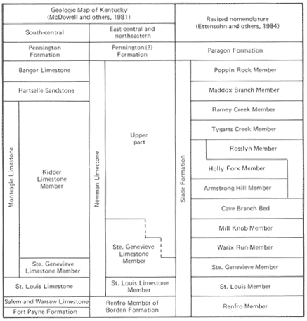
FIGURE 7.--Revision of part of the Mississippian nomenclature of eastern Kentucky. Modified from Ettensohn and others (1984, fig. 3) |
The Pennington Formation is composed primarily of greenish-gray and reddish-brown clay shale, with beds of fine- to medium-grained, crossbedded, fossiliferous limestone in the lower part and siltstone and fine-grained quartzose sandstone in the upper part. Dolomite beds occur in the lower and upper parts of the Pennington in south-central and east-central Kentucky (G.R. Dever, Jr., oral commun., 1982). The basal contact is sharp but normally poorly exposed, while the upper contact is unconformable with overlying sandstone or dark-gray silty shale of the Pennsylvanian Breathitt Formation. The contacts have generally been located on changes in slope morphology, and minor differences in thickness shown from place to place probably are not significant or necessarily real.
The lithologic similarity of the Pennington Formation of south-central Kentucky to the Pennington Formation of Cumberland Mountain in southeastern Kentucky has been considered sufficient to warrant the correlation of these two units across the Cumberland Plateau; they probably are not coeval (Englund, 1968, p. 12). The Pennington Formation of south-central Kentucky is traditionally correlated with the upper rocks of Chester age of western Kentucky, although the nature of the upper contact, and hence the youngest age of the Pennington, is not known. The formation was deposited in a variety of shallow-marine environments.
Newman Limestone, Fort Payne Chert, Grainger Formation, Sunbury Shale, Berea Sandstone, and Bedford Shale (MDng).--Along and south of the Pine Mountain overthrust fault in southeastern Kentucky the entire sequence of rocks from the top of the Chattanooga or Ohio Shale to the base of the Pennington Formation is shown as a single map unit. Approximately 1,000 ft of limestone, siltstone, and shale are exposed along a narrow band of dipping beds on the outcrop slope on the northwest side of Pine Mountain. The strata can be traced into Tennessee to the southwest and to the Kentucky-Virginia State line to the northeast.
The Berea Sandstone and the Bedford Shale crop out along Pine Mountain northeast of Harlan County, where they thin and pinch out within black shale (Froelich, 1973). These rocks, about 100 ft thick in Letcher and Pike Counties, are latest Devonian and Early Mississippian in age. The fine-grained, quartzose sandstone and siltstone of the Berea Sandstone occurs within the gray clay shale of the Bedford Shale. The lower and upper contacts of this interval are sharp and conformable with the Ohio and Sunbury Shales, respectively, but they are rarely exposed and are generally complicated by intense deformation. The overlying Sunbury Shale, about 50 ft of fissile, carbonaceous, silty shale, is distinguishable only where the Berea Sandstone and the Bedford Shale separate it from the Ohio Shale. Hence, equivalents of the Sunbury Shale are mapped as the upper part of the Chattanooga Shale south of Letcher County. The contact of the Sunbury with the overlying Grainger Formation is conformable and gradational over a few feet.
The Grainger Formation consists of 200 to 550 ft of basal silty shale and overlying siltstone with minor amounts of shale. This sequence is thickest in Pike County, where it consists of about 350 ft of greenish gray, silty to sandy shale with thin beds of fine-grained sandstone and siltstone, overlain by about 200 ft of red and green silty claystone and sandy siltstone (Maecrady and Price Members) (Alvord, 1971). The basal 20 ft of the Grainger contains numerous siderite nodules.
The Grainger Formation thins southwestward along the outcrop belt, but the general sequence of rocks remains the same. Along the Tennessee border, in Whitley County, the Grainger consists of about 200 ft of silty shale with some siderite nodules at the base, overlain by about 100 ft of siltstone and interbedded shale and siltstone (Newell, 1975); about 20 mi to the southwest in Tennessee it thins to a few feet of greenish gray clay shale (Englund, 1968). The coarsening-upward sequence and southwestward thinning are similar to these features of the Borden Formation of central Kentucky, with which the Grainger Formation is correlated.
In its southwesternmost exposures in Kentucky, the Grainger Formation is overlain by 10 to 20 ft of interbedded dolomite and chert (Newell, 1975; Rice and Newell, 1975). These rocks are an extension of the Fort Payne Chert, which thickens to the southwest along the outcrop belt and eventually occupies the entire interval from the top of the Chattanooga Shale to the base of the Newman Limestone; a thin layer of greenish-gray shale at the base represents the Grainger Formation. This inverse thickness relationship of the Fort Payne and the Grainger is similar to that of the Fort Payne Formation and elastic rocks of the Borden Formation in central Kentucky.
The Fort Payne Chert in Whitley and Bell Counties, and the Grainger Formation to the northeast, are overlain by 350 to 800 ft of Newman Limestone. In parts of Letcher and Whitley Counties the base of the Newman is composed of 10 to 30 ft of cherty, argillaceous and sandy dolomite (Newell, 1975), which may be equivalent to the Renfro Member of the Borden Formation of east-central Kentucky and the Salem and Warsaw Limestones of south-central Kentucky. Above these dolomites is 220 to 520 ft of northeastward thickening limestone. The lowest beds consist of cherty, fine-grained limestone which may be equivalent to the St. Louis Limestone Member of the Newman Limestone of east-central Kentucky. As much as 100 ft of crossbedded, oolitic, skeletal limestone occurs in the middle of this unit and may be equivalent to the Ste. Genevieve Limestone Member of the Monteagle Limestone of south-central Kentucky. The upper beds consist of argillaceous and fossiliferous skeletal limestone, possibly correlative with the Kidder Limestone Member of the Monteagle. In Virginia and West Virginia, the lower part of the Newman is called the Greenbrier Limestone.
In Letcher and Pike Counties, the upper part of the Newman Limestone consists of 80 to 350 ft of interbedded argillaceous, fossiliferous limestone and calcareous, fossiliferous shale, with lenses of carbonaceous siltstone and fine-grained sandstone in its upper part (Wolcott, 1974). This unit thickens to the southwest, where more limestone is present. The upper contact is gradational and intertonguing with the Pennington Formation. These rocks may be equivalent to the Bangor Limestone and the Hartselle Formation of south-central Kentucky and Tennessee and the Bluefield Formation of Virginia and West Virginia.
The entire sequence of rocks, from the top of the Chattanooga Shale to the base of the Pennington Formation, represents a transition from distal deep basin to proximal shallow shelf. The Berea Sandstone and the Bedford Shale are the distal portions of a delta that encroached into the black-shale-filled basin at the start of the Mississippian. This initial prodeltaic pulse from the north and east was followed by a later prodeltaic, coarsening-upward sequence also derived from the north and east, the Grainger Formation. The Fort Payne Chert is a basin-filling sequence that onlapped the earlier prodeltaic sediments from the south and west. The oolitic and skeletal limestone of the lower portion of the Newman Limestone formed in the clearer and more turbulent water of the shallow-marine shelf formed on the Fort Payne Chert and the Grainger Formation. Shoreline terrigenous deposits that encroached from the northeast and east are preserved in the upper part of the Newman.
The rocks of this map unit occur above the Pine Mountain overthrust fault and in a few minor fault blocks just below the overthrust. The massive limestone of the lower part of the Newman Limestone is commonly well exposed in steep, north-facing slopes of Pine Mountain. The argillaceous limestones, fine-grained sandstones, siltstones, and shales are poorly exposed, forming slopes covered with thick colluvium. The Fort Payne Chert is well exposed in streams and in eaves.
Pennington Formation (IPMp).--A thick unit of sandstone, siltstone, shale, and minor amounts of limestone is exposed along the northwest side of Pine Mountain in southeastern Kentucky between the Newman Limestone and the Lee Formation. These rocks, 300 to 1,150 ft thick, make up the Pennington Formation of Late Mississippian and Early Pennsylvanian age.
The Pennington Formation is thickest in Harlan, Letcher, and Pike Counties and in adjacent Virginia. The basal 120 to 340 ft, the Stony Gap Sandstone Member, is composed of fine- to medium-grained, micaceous sandstone that is locally interbedded with and gradational into siltstone and red and green shale (Alvord, 1971). This member thins and becomes more shaly to the southwest. The basal contact of the Stony Gap Sandstone Member is locally sharp and unconformable above the Newman Limestone. The remainder of the Pennington is a heterogeneous mixture of greenish-gray and reddish-brown siltstone and shale with some interbedded sandstone and limestone. Dark, carbonaceous siltstone and shale with a few thin coal beds occur near the top of the formation. Some of the siltstone and shale is calcareous, and fossiliferous fine- to medium-grained, micaceous sandstones about 10 to 20 ft thick occur at several intervals in the Pennington. Fine- to coarse-grained, locally conglomeratic, crossbedded quartzose sandstones occur in the middle of the Pennington and are interpreted to be tongues of the Lee Formation. These sandstones are as much as 120 ft in thickness and thin toward the southwest. The Little Stone Gap Member, a sandy limestone, is an important marker unit in the middle part of the Pennington Formation (Alvord and Miller, 1972).
Southwestward in Whitley and Bell Counties, the Pennington Formation is 300 to 600 ft thick and is divided into two informal members (Newell, 1975; Rice and Newell, 1975). The lower member is composed of interbedded shale, siltstone, and minor amounts of fine-grained, micaceous sandstone. The lower contact is gradational and intertonguing and is rarely exposed. Calcareous claystone occurs at the top of the unit and may be a local remnant of the Little Stone Gap Member (Maughan, 1976). The upper member of the Pennington consists of cliff-forming, crossbedded quartzose sandstone and greenish-gray, reddish-brown, and dark-gray carbonaceous siltstone and shale. The upper member is gradational into the lower member, while the upper contact of the unit is unconformable below the Lee Formation.
The Pennington Formation was deposited in a coastal marine environment. It forms the upper slopes on the northwest side of Pine Mountain. The sandstones form cliffs or steep slopes, whereas the shales, siltstones, and limestones form moderate slopes covered by blocks of sandstone.
NEXT || PREVIOUS || Return to STRATIGRAPHY