
CONTRIBUTIONS TO THE GEOLOGY OF KENTUCKY
By far the largest area of exposure of the Ordovician rocks is in central and north-central Kentucky along the crest and flanks of the Cincinnati arch (figs. 1, 2). The area of exposure, approximately 7,600 mi2, is coincident with the Bluegrass region (see physiographic diagram on sheet 1 of the geologic map). The Inner Bluegrass is underlain by Middle Ordovician rocks (fig. 1), and the Outer Bluegrass by Upper Ordovician rocks (fig. 2). Upper Ordovician rocks also crop out in two smaller areas in the south-central part of the State. These are along the Cumberland River and its tributaries from Wolf Creek Dam downstream to the Tennessee border and in southern Allen County along several tributaries to the Barren River.
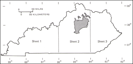 FIGURE 1.--Area of outcrop of High Bridge Group and Lexington Limestone (Ordovician) in Kentucky (shaded). |
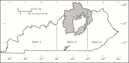
FIGURE 2.--Area of outcrop of Upper Ordovician strata in Kentucky (shaded). |
The Middle Ordovician consists mostly of limestone. The lower part, the High Bridge Group, is mostly of sparingly fossiliferous micrite and minor dolomite that was deposited in shallow lagoons and on tidal flats; the upper part, the Lexington Limestone, is mostly very fossiliferous limestone and fossil-fragmental calcarenite. The Upper Ordovician section consists of interbedded fossiliferous limestone or dolomite and shale; shale dominates some parts of the section, and limestone or dolomite other parts. Both the Lexington Limestone and the Upper Ordovician rocks were deposited in tropical latitudes in shallow marine water on a shelf that sloped gently northward.
The character, distribution, and history of nomenclature of Ordovician rock-stratigraphic units in Kentucky have been summarized by Weir and Cressman (1978). The Middle Ordovician rocks have been described in more detail by Black and others (1965), Cressman (1973), and Cressman and Noger (1976), and the Upper Ordovician rocks by Weir and others (1984). The following descriptions are taken largely from these references. An extensive bibliography can be found in Weir and Cressman (1978).
The character, stratigraphy, and depositional environments of the High Bridge Group have been described at length by Cressman and Noger (1976), and the following discussion has been derived largely from that report.
As shown on the stratigraphic column for east-central Kentucky, the High Bridge Group comprises three formations; these are, in ascending order, the Camp Nelson Limestone, the Oregon Formation, and the Tyrone Limestone. These formations were mapped separately for the geologic quadrangle maps and will be described separately. The Camp Nelson has been correlated with the Lebanon Limestone, and possibly part of the Ridley Limestone of central Tennessee, and with the Witten Limestone, and possibly part of the Wardell Formation of Cooper and Prouty (1943) of southwestern Virginia and northeastern Tennessee; the Tyrone has been correlated with the upper member of the Carters Limestone of central Tennessee and with the Cane Creek Formation of Cooper (1956) of southwestern Virginia and northeastern Tennessee (Cressman and Noger, 1976, p. 3).
Camp Nelson Limestone.--The Camp Nelson Limestone is dominantly micrite, pelmicrite, and biopelmicrite, all containing abundant subhorizontal dolomite-filled burrows that impart a ropy appearance to bedding surfaces. Mollusks, brachiopods, and bryozoans are present, though not in great abundance. About 320 ft of the formation are exposed near Camp Nelson.
A distinctive unit of calcareous, dolomitic shale, commonly stromatolitic and mud cracked and 5 to 12 ft thick, occurs 10 to 20 ft below the top of the formation. This unit is present throughout the outcrop area and can be traced widely in the subsurface by gamma-ray logs. It is shown on the stratigraphic columns for both east-central and west-central Kentucky.
Oregon Formation.--The Oregon is characterized by yellowish-gray thick-bedded finely crystalline dolomite that in much of the area is interbedded with limestone. The thickness of the formation ranges from 6 ft in its southernmost exposures near the south end of Herrington Lake to 65 ft near Boonesboro. The base of the Oregon is at about the same stratigraphic position throughout its outcrop area, and the thickening of the formation results from dolomite beds occurring higher in the section to the northeast. The dolomite is horizontally laminated and exhibits mud cracks and mud-chip breccias, indicating that the sediments were originally tidal-flat deposits.
Tyrone Limestone.--This formation ranges in thickness from 55 to 155 ft. The thicknesses of the Tyrone and the underlying Oregon Formation are complementary: where the Tyrone thickens, the Oregon thins. The Tyrone consists of a variety of limestone types. Most common are (1) interlaminated micrite and dolomite displaying abundant mud cracks, (2) laminated micrite with fenestral fabric and mud cracks, (3) micrite containing abundant vertical tubiform burrows, (4) micrite containing abundant fragments of the tabulate coral Tetradium, (5) crossbedded biopelsparite, (6) bioturbated biopelmicrite, and (7) micrite with dolomite filled burrows similar in appearance to much of the limestone of the Camp Nelson. Types 1 through 3 were deposited in tidal flats, whereas types 4 through 7 were deposited in shallow marine areas.
The Tyrone Limestone in central Kentucky contains at least five potassium bentonites. These are the Mud Cave bentonite of drillers at the top of the formation, the Pencil Cave of drillers 16 to 30 ft below the top, and three unnamed bentonites about 15, 55, and 65 ft below the Pencil Cave. Both the Mud Cave and Pencil Cave bentonites are locally as much as 2 ft thick, but the others are generally only a few inches thick. The lower three bentonites are discontinuous and the Mud Cave was removed from much of the area by erosion, but the Pencil Cave is present throughout nearly all of the outcrop area. It can be identified in the subsurface north to the Ohio River and south to the Tennessee border; it is widely distributed in the Central basin and the Sequachie Valley of Tennessee as the T-3 bentonite of Wilson (1949, p. 64). The Pencil Cave is the bentonite shown on the stratigraphic column for east-central and west-central Kentucky.
Following deposition of the Tyrone Limestone, the High Bridge strata were gently arched and slightly eroded along an east-west axis about 10 mi north of Lexington; as much as 10 ft of the uppermost Tyrone was removed (Cressman, 1973, p. 12). Subsequent marine transgression from the north and west initiated deposition of the Lexington Limestone.
The Lexington Limestone consists mostly of very fossiliferous and fossil-fragmental limestone that contrasts strikingly with the micrite-rich, sparingly fossiliferous rocks of the High Bridge Group. The Lexington is more than 320 ft thick along a line that extends from 10 mi north of Frankfort eastward through Georgetown and Paris. It thins northward from this line to 190 ft in Pendleton County, westward to about 200 ft in Shelby County, and southward to about 220 ft near Danville in Boyle County. The thinning results mostly from intertonguing of the upper part of the Lexington with the lower part of the Clays Ferry Formation, as illustrated by the generalized stratigraphic sections of the Lexington Limestone. Intertonguing of the two formations was shown on the geologic quadrangle maps, but the contact is generalized on the State geologic map by necessity of the scale.
Outcrop of the Lexington Limestone in Kentucky (fig. 1) is limited to the Inner Bluegrass region, most of which is on sheet 2 of the geologic map, with a small area on sheet 3. Lateral equivalents of the Lexington in adjacent States have been described by Freeman (1953), Wilson (1949, 1962), and Cressman (1973). The interval in general contains less limestone and more shale to the north and west; the Nashville Group to the south differs principally in a change in facies trends from east-west to north-south (Cressman, 1973, p. 55).
The Lexington Limestone comprises 12 members which are described below. The members are limestone lithofacies, and the relations between them are complex. These relations are illustrated by the generalized stratigraphic sections and in more detail by Cressman (1973, pl. 7, 8).
Curdsville Limestone Member.--The Curdsville Limestone Member, the basal member of the Lexington, consists of 20 to 40 ft of bioclastic calcarenite, which is sandy and chert-bearing in part; silicified fossils are common. Near the top of the member, the limestone becomes irregularly bedded, finer grained, and more fossiliferous. MacQuown (1967) identified several thin, discontinuous bentonites in the Curdsville. The Curdsville was deposited in shallow, turbulent water during the initial transgression of the Lexington sea. The member is present throughout the outcrop area.
Logana Member.--In most of its area of exposure, the Logana Member consists of three parts: (1) a lower unit of interbedded calcisiltite and shale, (2) a middle coquinoid limestone consisting of closely packed shells of the brachiopod Dalmanella sulcata, and (3) an upper, thinner unit of interbedded calcisiltite and shale. The calcisiltite is generally in even or broadly lenticular beds 0.2 to 0.3 ft thick and is mostly unfossiliferous, though pelecypods and scattered Dalmanella are present in some beds. The member is about 50 ft thick in Pendleton County but thins southward to a featheredge that extends northeastward from Harrodsburg in Mercer County. The thinning results largely from lateral gradation of the upper part into fossiliferous limestone of the Grier Limestone Member but also, in part, from gradation of the lower part into the Curdsville Limestone Member. The Logana was deposited during the culmination of the initial transgression of Lexington time.
Grier Limestone Member.--This member typically consists of sets of modularly bedded fossiliferous calcisiltite to very poorly sorted fossiliferous calcarenite alternating with irregular beds of poorly sorted fossiliferous calcarenite. Shale partings are common. The member is characterized by abundant fossils, poor sorting, and bedding disrupted by bioturbation. The fauna are varied, but the most common fossils are brachiopods and bryozoans. The Grier contains an average of 0.8 percent P205 present as carbonate-fluorapatite. The phosphate mineral occurs as fillings in bryozoan zooecia, in pores of crinoid plates, and as steinkerns of ostracodes and minute gastropods. The Grier ranges in thickness from 100 ft in Pendleton County to 180 ft in westernmost Montgomery County. The variations in thickness result mostly from intertonguing with other members of the Lexington. The limestones were deposited in the infralittoral zone where light, aeration, circulation, and the availability of nutrients were at an optimum to foster life.
Brannon Member.--The Brannon Member is a distinctive unit of interbedded calcisiltite and shale, as much as 30 ft thick and in about the middle of the Lexington Limestone, that crops out from Frankfort and Lexington south to and beyond the Kentucky River. Fossils are sparse. On uplands, the Brannon weathers to yield abundant porcelaneous and punky chert fragments. In much of the area the uppermost beds are contorted and display ball-and-pillow structure. North of a line from Frankfort to Lexington, the Brannon passes laterally into calcarenite of the Tanglewood Limestone Member, as shown by the generalized stratigraphic sections of the Lexington Limestone. To the southwest, the Brannon thins as a result of erosion before deposition of the overlying Sulphur Well Member.
Perryville Limestone Member.--This member is present in the southwestern part of the Inner Bluegrass region. It forms a wedge that thickens to the southwest from a featheredge 5 mi northeast of Harrodsburg to about 50 ft at Perryville in Boyle County. The thickening results from a facies change; the Perryville passes northeastward into calcarenite of the lower part of the Tanglewood Limestone Member, and the calcarenite, in turn, passes into fossiliferous limestone of the Grier Limestone Member. The Perryville consists of two major rock types. The first is brownish-gray calcisiltite in rough-surfaced beds. Mollusks, tabulate corals, and stromatoporoids dominate the fauna. Algal-coated fossil fragments are common. The second is light gray calcilutite, some of which contains tubiform burrows and some of which is horizontally laminated. The member was deposited in quiet, restricted water in the lee of a band of calcarenite bars.
Tanglewood Limestone Member.--The Tanglewood is an extensive irregular body of fossil-fragmental calcarenite that makes up much of the upper part of the Lexington Limestone in the Inner Bluegrass region. The member intertongues with the Clays Ferry Formation and with all other members of the Lexington Limestone except the Curdsville Limestone and Logana Members. The calcarenite is typically well sorted and crossbedded. It contains an average of 2.4 percent P20,5, though the amount varies greatly from bed to bed. The phosphate grains are similar to those in the Grier Limestone Member but have been reworked, rounded, sorted, and concentrated by currents. The Tanglewood was deposited on the shallowest parts of the shelf, where waves and currents could break, abrade, and sort skeletal material, and on bank margins, where tidal currents would have attained maximum velocity.
Sulphur Well Member.--In the southwestern part of the Inner Bluegrass, the Brannon Member is overlain, mostly disconformably, by as much as 35 ft of limestone that contains extremely abundant bryozoans. This bryozoan limestone is the Sulphur Well Member. The northern edge of the Sulphur Well is in central Jessamine, southern Woodford, and Anderson Counties, from where it grades northward into part of the Tanglewood Limestone Member; southward it intertongues with the basal part of the Clays Ferry Formation.
Millersburg Member.--The Millersburg Member is a body of nodular and irregularly bedded fossiliferous limestone and shale in the upper part of the Lexington Limestone. The limestone consists of very abundant whole and broken fossils in a silt- and clay-sized carbonate matrix. Bryozoans, brachiopods, mollusks, and trilobite fragments are particularly abundant, and stromatoporoids and colonial corals are present in some zones. The Millersburg closely resembles in character the Grier Limestone Member, though it contains much more shale, and, like the Grier, the Millersburg averages 0.8 percent P205. The Millersburg is 90 ft thick in western Montgomery County and thins to a featheredge north of Cynthiana in Harrison County, near Frankfort, and near the Kentucky River south of lexington. The thinning results largely from a facies change; northward the Millersburg intertongues with the Clays Ferry Formation, and westward and southward it passes into the Tanglewood Limestone Member. The Millersburg was deposited on a shallow bank that occupied what is now the central part of the Inner Bluegrass. Light, agitation, and circulation on the bank supported abundant life.
Greendale Lentil.--This unit, 10 to 15 ft thick and not shown on the stratigraphic section, is similar in character to the Millersburg Member. It crops out in an area 3 by 5 mi on the northern outskirts of Lexington. It is underlain and overlain by calcarenite of the Tanglewood Limestone Member, and it grades in all directions into the Tanglewood. The base of the lentil is about 30 ft above the base of the Brannon Member.
Stamping Ground Member.--The Stamping Ground Member is a unit of nodular fossiliferous limestone and shale as much as 15 ft thick that is very similar in lithology to both the Greendale Lentil and the Millersburg Member but is continuous with neither. The member crops out in a band about 5 mi across that extends from south of Paris in Bourbon County through Georgetown to southern Henry County. The Stamping Ground is underlain and overlain by, and passes laterally into, calcarenite of the Tanglewood Limestone Member. A conspicuous zone of stromatoporoids is present in the upper part of the member throughout most of its area of exposure. The Stamping Ground is not shown on the generalized stratigraphic sections.
Devils Hollow Member.--This member, not shown on the generalized stratigraphic section, is about 50 ft above the base of the Brannon Member and crops out in a belt as much as 8 mi wide that extends from Frankfort southeastward for about 30 mi. The member is a maximum of about 30 ft thick. It consists of three principal rock types: (1) gastropod coquina, in places displaying low-angle crossbedding, (2) light-gray calcilutite, some of which is stromatolitic, and (3) brownish-gray bioturbated calcilutite to calcisiltite containing abundant ostracodes and laminar stromatoporoids. The coquina was apparently deposited as bars and beaches that segregated a lagoon in which the calcilutites and calcisiltites were deposited.
The Devils Hollow is underlain by the Tanglewood Limestone Member and overlain either by the upper part of the Tanglewood or by the Millersburg Member.
Strodes Creek Member.--The Strodes Creek (Black and Cuppels, 1973), not shown on the generalized stratigraphic section, crops out east of a line from Cynthiana to Winchester. It is both underlain and overlain by the Millersburg Member. It consists of brownish-gray bioturbated calcilutite and calcisiltite and characteristically contains abundant stromatoporoids and sparse but conspicuous ostracodes. It represents deposition in waters more sheltered than those of the Millersburg.
The Upper Ordovician strata are composed of limestone, shale, siltstone, dolomite, and mudstone, but limestone and shale make up the bulk of the sequence. Most of the limestone is composed of whole and broken fossils and an interstitial fine- to coarse-grained fossil fragmental matrix. It is cemented by microspar and lesser amounts of sparry calcite; rarely, the cement is micrite. Most of this limestone is nearly free of quartz silt and clay, but some limestone, particularly where nodular bedded, contains considerable amounts of these impurities. A small percentage of the limestone is sparsely fossiliferous calcisiltite and calcarenite, and a still smaller amount is sparsely fossiliferous micrite. The limestone is generally medium gray when fresh and olive gray, yellowish gray, and, rarely, brown where weathered. The shale is highly calcareous, silty, and crudely fissile and ranges from very sparsely fossiliferous to very fossiliferous; it is greenish gray or olive gray when fresh and yellowish gray where weathered.
The siltstone is calcareous and very sparsely fossiliferous, and occurs mostly in even beds commonly 2 to 4 in thick, although locally it is contorted into ball-and-pillow structures. It is medium gray when fresh and weathers yellowish gray and brown. In many places, the siltstone forms coherent float blocks from which the calcite has been leached.
The dolomite is commonly calcitic and grades to dolomitic limestone; quartz silt is commonly present, and the dolomite also grades by increase in silt content to dolomitic calcitic mudstone. These dolomites, dolomitic limestones, and mudstones are composed mostly of silt-sized grains and are unfossiliferous or very sparsely fossiliferous. The dolomite, and some dolomitic limestone, are laminated in many places and locally are mud cracked and ripple marked. The mudstone and some of the dolomitic limestone are not laminated and appear to be bioturbated. The dolomite, dolomitic limestone, and mudstone are medium gray and greenish gray when fresh and greenish gray and yellowish green where weathered.
The fossils are chiefly brachiopods and branching (twiglike) bryozoans. Less abundant are pelecypods, gastropods, and trilobites; orthoconical cephalopods, colonial and solitary corals, stromatoporoids, and ostracodes occur in some beds. A large part of the Upper Ordovician strata, perhaps 40 percent, is limestone made up of animal skeletons that are whole, broken to large pieces, or comminuted into sand- and silt-sized fragments.
Two generalized stratigraphic cross sections shown on the geologic map, at the base of sheet 2 and at the top of sheet 3, illustrate the north-south distribution of the formations and members from the top of the Ordovician to the base of the Clays Ferry Formation. As indicated by these cross sections, the lithofacies tend to change from north to south and not from east to west. The ensuing discussion of the distribution of the formations is more easily followed if these cross sections are referred to.
Garrard Siltstone and Kope and Clays Ferry Formations (Okc).-The Clays Ferry Formation, 90 to 300 ft thick, is made up of interbedded limestone, shale, and minor siltstone. The limestone and shale occur in about equal amounts, while the siltstone accounts for only a small percentage and is more abundant near the top, especially near the contact with the Garrard Siltstone. The limestone is mostly very fossiliferous and occurs in even beds commonly 2 to 6 in thick. A small percentage of the limestone is sparsely fossiliferous calcisiltite, mostly near the base. The shale is commonly sparsely fossiliferous and also generally occurs in beds 2 to 6 in thick. The shale beds commonly have sharp contacts with the limestone beds. The Clays Ferry intertongues northward on a small scale with the Kope across a broad zone that trends roughly east-west. The Point Pleasant Tongue of the Clays Ferry Formation is lithologically similar to the main body of the Clays Ferry and extends northward beneath the Kope Formation. It is generally 100 to 130 ft thick. Both the Clays Ferry and the Kope intertongue in part with the Lexington Limestone. The Garrard Siltstone occurs above the Clays Ferry (locally, the Kope) in the southeastern part of the main outcrop area of the uppermost part of the Clays Ferry.
The Garrard Siltstone, which ranges in thickness from 0 to 100 ft, is composed of interbedded siltstone, shale, and limestone. Shale accounts for less than 20 percent, and limestone less than 10 percent. The siltstone is in even beds a few inches to several feet thick which are locally contorted into ball-and-pillow structures. The Kope Formation is composed of interbedded shale (about 60 to 80 percent), limestone (20 to 40 percent), and minor siltstone; it ranges in thickness from 200 to 275 ft. The shale commonly occurs in beds 2 to 5 ft thick and is generally very sparsely fossiliferous. Most of the limestone is fossiliferous and commonly occurs in even beds 2 to 6 in thick that are in places grouped into sets several feet thick. The limestone beds commonly have sharp contacts with the shale beds.
Cumberland Formation and Leipers and Catheys(?) Limestones (Oci).-The Catheys(?) Limestone is exposed only in the Cumberland River Valley for a few miles north of the southern border of the State, where only the upper 80 ft crops out. It consists of fossiliferous limestone in even to nodular beds 2 to 24 in thick that are interstratified with thinner beds of shale.
The Leipers Limestone is composed of limestone (70 to 90 percent) and interbedded shale. The limestone is fossiliferous and occurs in nodular or irregular beds that are commonly I to 4 in thick. The shale is also fossiliferous; it occurs as wispy partings and thin beds. The limestone and shale tend to be indistinctly separated and grade from one to the other. The large, globular brachiopod Platystrophia ponderosa is abundant and contributes to the nodular nature of the bedding. In the Blacks Ferry quadrangle, at the southern border of the State, the only quadrangle where the base of the formation crops out, the Leipers ranges in thickness from 120 to 180 ft.
The Cumberland Formation is composed chiefly of silt-sized dolomite, with much lesser amounts of dolomitic mudstone and siltstone and a still smaller component of limestone. The dolomite is distinctly to obscurely laminated; otherwise, stratification is indistinct. Mud cracks and ripple marks occur locally. The dolomite, mudstone, and siltstone are commonly unfossiliferous or very sparsely fossiliferous; the limestone is sparsely or moderately fossiliferous. The range in thickness of the Cumberland, from 0 to 130 ft, was caused by erosion prior to deposition of the superjacent Devonian rocks.
The Cumberland Formation grades northward into the Ashlock and Drakes Formations, and the Leipers Limestone into the Calloway Creek Limestone; the transition between the Catheys(?) and the Clays Ferry Formation (or Garrard Siltstone) is not exposed and therefore is obscure.
Ashlock Formation, Grant Lake and Calloway Creek Limestones, and Fairview Formation (Oaf).-The Calloway Creek Limestone is composed of limestone, shale, and minor siltstone. It is mostly fossiliferous limestone which occurs in even and nodular beds that are commonly 1 to 4 in thick. Limestone makes up 70 percent or more of the Calloway Creek, which ranges in thickness from 60 to 150 ft. Shale occurs as partings and thin beds. It ranges from very fossiliferous to unfossiliferous. Siltstone occurs almost exclusively in the lower one-third and commonly accounts for 1 or 2 percent of the formation.
The Fairview Formation is mostly fossiliferous limestone and interbedded shale in about equal amounts; siltstone is a minor constituent. The limestone is in even beds I to 4 in thick. The shale beds are of similar thickness and are commonly sparsely fossiliferous; they generally have sharp contacts with the limestone beds. The Fairview ranges in thickness from 40 to 130 ft.
The Ashlock Formation consists of several members: Tate, Gilbert, Stingy Creek, Terrill, Sunset, Grant Lake, and Reba. All members do not occur in all areas of exposure. The Tate and Gilbert are the most widespread and, in most places, the thickest. The Ashlock consists of interlayered units that are a few to 80 ft thick and are composed of (1) sparsely fossiliferous or nonfossiliferous laminated dolomitic and dolomitic limestone, (2) nonlaminated dolomitic mudstone, and (3) very fossiliferous nodular-bedded limestone and a lesser amount of interbedded fossiliferous shale. Much of the limestone is wavy bedded and consists of microspar and micrite. The Ashlock, 60 to 150 ft thick, is an intertongued unit between the dolomitic mudstone and siltstone of the Cumberland Formation on the south and the nodular-bedded limestone and shale of the Grant Lake Limestone on the north.
The Grant Lake Limestone is composed of thinly interbedded fossiliferous limestone (70 to 90 percent) and shale. The limestone occurs in nodular or irregular beds that are commonly 1 to 4 in thick. The shale is fossiliferous and occurs as irregular partings and thin beds. The limestone and shale tend to grade indistinctly into each other. The large globular brachiopod Platystrophia ponderosa is abundant and, as in the Leipers Limestone, contributes to the nodular nature of the bedding. The thickness of the Grant Lake ranges from 3 to 160 ft.
Bull Fork Formation (0b).-The Bull Fork Formation is composed of fossiliferous limestone interbedded with sparsely fossiliferous shale in about equal amounts. The limestone is in even beds commonly 1 to 4 in thick which are sharply set off from the shale beds of similar thickness, generally with sharp contacts. The Bull Fork Formation ranges in thickness from about 90 to 240 ft.
Drakes Formation (0d).-The Drakes Formation consists of four members: Rowland, Preachersville, Bardstown, and Saluda Dolomite Members. The Rowland and Preachersville occur in the eastern part of the Outer Bluegrass region, and the Rowland, Bardstown, and Saluda occur on the west side. The Drakes Formation is composed of dolomite, limestone, mudstone, and shale. Dolomite, dolomitic limestone, and mudstone are most abundant and are commonly composed of silt-sized grains, are sparsely fossiliferous or unfossiliferous, partly laminated, and locally mud cracked and ripple marked. The Bardstown Member, which makes up only a small part of the total Drakes, is composed of fossiliferous limestone in irregular or nodular beds thinly interbedded with fossiliferous or sparsely fossiliferous shale. The Drakes Formation generally ranges in thickness from 20 to 150 ft. In south-central Kentucky, it is locally cut out by the unconformity at the base of the Devonian rocks.
The contact with overlying Silurian rocks appears to be conformable in at least one place, near Bardstown, on the western side of the Cincinnati arch and in most places on the eastern side, but is mostly disconformable or paraconforrnable (Peterson, 1981; McDowell, 1983). On the crest of the arch in south central Kentucky, as much as 250 ft or more of Upper Ordovician strata, as well as the entire Silurian, were removed prior to deposition of Devonian rocks.
No evidence of warping that would indicate formation of the Cincinnati arch is discernible in the geometry of the sedimentary bodies or in the facies changes in the Upper Ordovician. The sedimentary facies and unit thicknesses do not change across the axis of the arch. The north-south facies changes seem to have no relationship to the arch. The northern part of the Bluegrass region may have been downwarped relative to the southern part during deposition of the sediments, thus maintaining the deeper water to the north, but it is also possible that the relative depths were maintained by rates of sedimentation. The present Cincinnati arch is thus the result of the post-Ordovician warping.
NEXT || Return to STRATIGRAPHY