
CONTRIBUTIONS TO THE GEOLOGY OF KENTUCKY
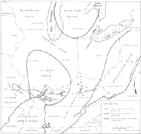
FIGURE 15.--Structural setting of the eastern midcontinent. [Click on image to see a larger version in a new window.] |
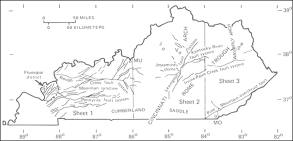
FIGURE 16.--. Solid lines indicate fault traces. P, Elliott County peridotite intrusion. Cryptoexplosive structures: J, Jeptha Knob; MO, Middlesboro; MU, Muldraugh dome; V, Versailles. |
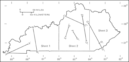
FIGURE 17.-Index to location of cross sections on the geologic map. |
The following brief descriptions of the four structural provinces include discussions of their regional setting, major structural features, and tectonic history, including age of deformation where known.
The Mississippi Embayment is currently delineated by the Cretaceous and Tertiary coastal plain strata (see sheet I of the geologic map). The current form of the embayment in Kentucky was established in latest Cretaceous time, after subsidence and erosion of the Pascola arch to the south (Olive, 1980, p. 5). The basin may have originated much earlier, however: Schwalb (1969, p. 9) identified a Cambrian-Ordovician basin of sedimentation, the Reelfoot basin, in roughly the same position, and Cressman (1973, p. 57) interpreted regional facies relationships of the Lexington Limestone of central Kentucky and adjacent States as implying the presence of an ancestral Mississippi Embayment. Ervin and McGinnis (1975) suggested, largely on the basis of geophysical data, that the present embayment stems from the late Mesozoic reactivation of the failed arm (the "Reelfoot rift") of a late Precambrian triple junction. A recent seismic study of the crustal structure of the embayment by Austin and Keller (1982) is consistent with this model.
Recent geophysical, geological, and seismological studies of the Reelfoot basin, which underlies the Jackson Purchase and extends southwestward into Missouri, Arkansas, and Tennessee, suggest that it is a fault bounded rift zone which is responsible for the relatively high level of modern seismic activity in the New Madrid earthquake region (McKeown, 1982), which includes much of western Kentucky.
Illinois basin.--The Illinois basin is a major structural downwarp in the eastern midcontinent, occupying large parts of Illinois, Indiana, and Kentucky and lying between the Ozark uplift on the west and the Cincinnati and Kankakee arches on the north and east (fig. 15). (The Illinois basin is referred to in some reports, for example, Sable (1979), as the Eastern Interior basin; others, such as Snyder (1968), use the latter term to include the Michigan basin as well. Therefore, the term "Illinois basin" is used herein to avoid confusion.) The southern part of the Illinois basin lies in Kentucky and includes the Pennsylvanian strata of the western coal field (sheet I of the geologic map). Major structural elements within the basin in Kentucky are the Rough Creek and Pennyrile fault systems, the Moorman syncline, and faults in and around the Illinois-Kentucky fluorspar district (fig. 16).
The Rough Creek fault system (Rough Creek-Shawneetown of some authors) crosses the southern end of the Illinois basin in Kentucky and forms the northern boundary of the east-west-trending Moorman syncline (fig. 16). The Moorman syncline extends into southern Illinois, where it is known as the Eagle Valley syncline (Krause and Treworgy, 1979). The Rough Creek fault zone is made up of numerous high angle normal faults and less common reverse faults bounding a series of grabens and horsts, with a total displacement, down to the south, generally of about 300 ft but locally as much as ten times that (see cross section B-B' on sheet I of the geologic map). The Pennyrile fault system (Green River fault zone of Lidiak and Zietz, 1976), marking the southern boundary of the Moorman syncline, is similar in form to the Rough Creek but has fewer and smaller faults; fault scarps along this system exposed by strip mining of the coal fields indicate dip-slip movement (Palmer, 1969). Whaley and others (1980), in a description of the structures of the southernmost Illinois basin, report little or no lateral offset but significant vertical movement on the Rough Creek fault system through at least Early Permian time. Geophysical studies by Soderberg and Keller (1981) indicate that the Moorman syncline is underlain by a large graben, which they name the Rough Creek graben, that was active as early as latest Precambrian or earliest Cambrian time and that has been reactivated in the late Paleozoic and possibly Mesozoic. Buschbach and Atherton (1979) suggest that most movement on faults at the southern end of the Illinois basin took place at the end of the Paleozoic.
The Illinois-Kentucky fluorspar district, at the west end of the Moorman syncline, is a structurally complex area dominated by numerous closely spaced high-angle faults trending northeastward from the Mississippi Embayment across a gentle, northwest-trending arch (Heyl and others, 1965; Pinckney, 1976; Trace and Amos, 1984).
Cincinnati arch.--The Cincinnati arch, a prominent regional uplift in the eastern midcontinent, extends from the Nashville dome in central Tennessee through central Kentucky to northwestern Ohio, where it bifurcates to form the Kankakee and Findlay arches (fig. 15). The arch thus separates the Appalachian basin from the Illinois and Michigan basins. Principal structural features of the arch in Kentucky are the Jessamine dome (Lexington dome of some authors), a culmination of the arch in central Kentucky; the Cumberland saddle, the depression between the Jessamine dome and the Nashville dome of Tennessee; and the Lexington, Kentucky River, and Irvine-Paint Creek fault systems (fig. 16). These structures appear on sheet 2 of the geologic map; the Irvine-Paint Creek fault system extends well into sheet 3 as well. Quadrangle mapping has revealed numerous minor normal faults and grabens, many en echelon in northwest-trending zones and some associated with dolomitization (Black and Haney, 1975).
The Jessamine dome (fig. 16; not labeled on the geologic map) occupies most of central Kentucky, as indicated by the outcrop area of the oldest rocks exposed in the State, the High Bridge Group (Ohb) of Middle Ordovician age and the Lexington Limestone (01) of Middle and Late Ordovician age. The broad, gentle dome culminates near the intersection of the Lexington and Kentucky River fault systems (fig. 16). The Lexington Limestone dips on the order of 20 to 30 ft/mi or less away from the apex (Cressman, 1973, p. 8). Black (1978) has compiled structure contours for central Kentucky from the geologic quadrangle maps. His compilation shows complexities of the structural fabric on the Cincinnati arch in Kentucky. Geophysical surveys of the area (Black and others, 1977) show a close relationship between gravity and magnetic data and the structure as mapped at the surface. Cross sections C-C' through F-F' on sheet 2 of the geologic map show the general aspect of this broad uplift and the high-angle fault systems that transect it.
The time of formation of the Cincinnati arch in central Kentucky has recently been discussed by McDowell (1983, p. 24). Atherton (1971, p. 37) suggested that the Kankakee arch, the northwestward extension of the Cincinnati arch (fig. 15), rose at the close of Early Ordovician time. Although some reports indicate an Early Ordovician inception of the arch in Kentucky, the geologic quadrangle mapping has shown no features of stratigraphy or sedimentation of the Ordovician rocks that can be related to the arch (Cressman, 1973, p. 8; Weir and others, 1984), though Borella and Osborne (1978) suggested that the area of the Jessamine dome was a shoal in late Middle and early Late Ordovician time. First obvious indications of the arch occurred in Early Silurian time (McDowell and Peterson, 1980; McDowell, 1983), when strata of the eastern flank began to thicken into the Appalachian basin. Pronounced effects of arching are shown by pre-Middle Devonian truncation of Upper Ordovician and Silurian beds (see section F-F', sheet 2 of the geologic map). Faulting concurrent with this early period of arching has been demonstrated by Simmons (1966). The arch continued to be a positive feature in Devonian time, but its influence on sedimentation in Kentucky waned and probably disappeared during most of the Mississippian and Pennsylvanian (Rice and others, 1979, p. F5, F21). Although the arch was a positive structural element through much of the Paleozoic, strata were exposed and subjected to erosion only briefly at the end of the Ordovician, during the period of intensive upwarping in the Early to Middle Devonian, and again during formation of the regional Mississippian Pennsylvanian unconformity. The present structural relief on the arch results mostly from latest Paleozoic or post-Paleozoic movement.
Appalachian basin.--The eastern part of Kentucky, particularly the area east of the Pottsville Escarpment, lies in the western part of the Appalachian basin. This area, mostly on sheet 3 of the geologic map, forms a part of the Cumberland Plateau and is represented at the surface mainly by strata of Pennsylvanian age. The basin as a whole contains sedimentary rocks of Precambrian to Early Permian age in a sequence that has a composite thickness for the entire basin of at least 63,000 ft but reaches a maximum thickness in any one place of about 35,000 ft (Colton, 1970, p. 13).
The Appalachian basin is divided structurally into an eastern highly deformed part, the fold-and-thrust province, and a western mildly deformed part referred to as the Appalachian Plateaus; the latter include the Cumberland Plateau of Kentucky and Tennessee. The boundary between these two structural provinces, the Allegheny Front, is placed by many workers at the Pine Mountain overthrust (fig. 16), resulting in the inclusion of the Cumberland thrust sheet of southeasternmost Kentucky in the fold-and-thrust province.
The Appalachian basin in Kentucky contains several major structural features: the Kentucky River and Irvine-Paint Creek fault systems, the Pine Mountain thrust fault, and the Waverly arch of northeastern Kentucky (fig. 16). The general configuration of the basin is shown by a contour map of the base of the Pennsylvanian system compiled by Coskren and Rice (1979) from data derived from drilling records and from the geologic quadrangle mapping. The Kentucky River fault system has been extended eastward, beyond the surface faults shown on the map (sheets 2 and 3), as a concealed system that extends into West Virginia (Dever and others, 1977). The Irvine-Paint Creek fault system extends eastward from central Kentucky to a terminus near Paintsville (sheet 3 of the geologic map); the southern block is displaced downward as much as 200 ft. The Pine Mountain overthrust fault brings Devonian and younger rocks northwestward over Pennsylvanian rocks with a total displacement of about 7.5 mi (Rice, Sable, and others, 1979, p. F23) (see cross section G'-G"). Harris (1970) has shown the fault to be a ramp on a bedding plane thrust that underlies the structurally complex Middlesboro syncline. The Waverly arch and the Kentucky River fault system largely predate Pennsylvanian deposition and are thus not readily apparent on the geologic map; evidence of these features has been reported from Mississippian and older rocks in northeastern Kentucky (Dever and others, 1977). Cable and Beardsley (1984) have traced the westward migration of an arch through northeastern Kentucky in the Late Cambrian and Early Ordovician; they suggest that the Waverly arch represents the position of this migratory arch during Beekmantown (Early Ordovician) deposition.
Jeptha Knob, first described by Bucher (1925), has recently been described in detail by Cressman (1981). The structure, about midway between Louisville and Lexington (sheet 2), is 14,000 ft in diameter. It is characterized at the surface by concentric and radial faults, an uplifted, brecciated, and partly dolomitized central area, and a downdropped peripheral belt. The age is closely constrained: disturbed beds include rocks as young as latest Ordovician, which are capped in the central part by undeformed earliest Silurian strata. The origin of the Jeptha Knob structure is uncertain, but meteoroid impact seems most likely (Cressman, 1981, p. 14).
The Versailles cryptoexplosive structure was discovered during the cooperative mapping project and has been described by Black (1964). The feature is about 5,000 ft in diameter and is in limestones and shales of Middle and Late Ordovician age; no younger beds are preserved in the area. At the surface it is represented by a brecciated center within a belt of concentric faults. The Versailles structure is about 10 mi west of Lexington (sheet 2 of the geologic map), near the axis of the Cincinnati arch (fig. 16).
The town of Middlesboro, in far southeastern Kentucky (sheet 3), is located in a topographic basin that is the expression of a cryptoexplosive structure nearly 4 mi across in Lower and Middle Pennsylvanian rocks. Englund and Roen (1963) suggested a meteor-impact origin for the structure on the basis of the presence of shatter cones and other features.
The origin of the Muldraugh dome is uncertain. It is a domal structure, about 2 mi in diameter and unfaulted at the surface, which has a structural relief of about 400 ft (Withington and Sable, 1969). This structure is not labeled on the geologic map, but it appears as a small, round outcrop area of the Muldraugh Member of the Borden Formation (Mbf) at the east margin of sheet 3 about 4 mi south of the Ohio River. Freeman (1951, p. 38) reported wells penetrating brecciated Knox dolomites and cherts below coherent Silurian dolomite, suggesting a "crypto-volcanic" nature. Cressman (1981) suggested that Mississippian doming over a pre Silurian deformational event argues against an impact origin.
The nature of the Precambrian basement is not well known. McGuire and Howell (1963, p. 2-4) presented sparse data on samples from the nine basement test wells. Keller and others (1982, p. 218), on the basis of considerably more data, report a close correlation between gravity anomalies and basement lithology: granites, metasediments, and felsic volcanics are associated with gravity lows, while mafic volcanics, amphibolites, and mafic granulites are found in the vicinity of highs. In addition, Keller and others (1982) summarized the available gravity, magnetic, seismic refraction, and petrologic data for Kentucky and described a Precambrian (Keweenawan) rifting event that resulted in formation of the east-continent gravity high, which passes north-south through east-central Kentucky. The Grenville Front, apparently in response to some later event, formed along the western margin of the gravity high (Lidiak and Zeitz, 1976; Keller and others, 1982, p. 220). Denison and others (1984), in a report on basement rock types and age in Kentucky and adjacent States, indicate that the dominant rock types east of the Grenville Front are granite gneiss, two-feldspar granite, medium-grade metamorphic rock, and anorthosite, while west of the front trachyte, rhyolite basalt, and weakly metamorphosed sedimentary rocks are characteristic. Ages range from about 1,500 to about 1,000 m.y. Denison and others (1984, fig. 5) also show right lateral offset of about 70 mi on the Grenville Front at the Kentucky River fault system and a north-trending basaltic rift zone some 30 mi wide, which coincides with gravity and magnetic highs and extends from south-central Kentucky into Tennessee and Alabama. King and Zeitz (1978) have recognized the New York-Alabama basement lineament, defined by aeromagnetic and gravity data, which lies across the easternmost tip of Kentucky; they postulate large-scale strike-slip displacement in basement rocks under the Appalachian basin, perhaps marking a region of continental collision associated with the Grenville event.
Exploration for oil and gas in Kentucky has resulted in considerable information on the nature of the unexposed Cambrian and Ordovician strata. Most of this data has been summarized by McGuire and Howell (1963), who applied the name Rome trough to a belt of thickened Cambrian Rome Formation in the subsurface of eastern Kentucky. Webb (1969) and Silberman (1972) have interpreted subsurface data as indicating growth faulting with a total throw at the top of the Precambrian of 5,000 ft along the northern border of the trough, which coincides with the Kentucky River fault system. Deposition of the Upper Cambrian-Lower Ordovician Knox Group in eastern Kentucky was significantly affected by continuing subsidence of the Rome trough (Cable and Beardsley, 1984). Harris (1978) combined the Rome trough with the Moorman syncline of western Kentucky as the "Eastern Interior Aulacogen" and traced the trough from eastern Kentucky northeastward across West Virginia into Pennsylvania. However, Ammerman and Keller (1979) mapped the Rome trough in eastern Kentucky by gravity and deep drilling data and concluded that it does not extend westward of the Lexington fault zone. Geophysical studies of the Moorman syncline by Soderberg and Keller (1981) suggest that it is underlain by a deep-seated graben of late Precambrian age, which they call the Rough Creek graben.
Major tectonic events in Kentucky for which evidence has accumulated begin with late Precambrian rifting in western Kentucky (the Rough Creek graben of Soderberg and Keller (1981) and the Mississippi Embayment) and in central Kentucky (Keller and others, 1982). This was followed by Middle(?) Cambrian rifting in eastern Kentucky (Rome trough: Harris, 1975; Ammerman and Keller, 1979) and post-Ordovician initiation of the Illinois and Appalachian basins. Late Paleozoic (Alleghenian) thrusting in southeasternmost Kentucky was succeeded by intrusion of ultramafic dikes (western Kentucky) and diatremes (eastern Kentucky). The Mesozoic and Cenozoic were characterized by uplift and minor faulting, associated with extensive denudation.
Parts of Kentucky may be profoundly affected by seismicity in the well-known New Madrid seismic zone of southeasternmost Missouri, northeasternmost Arkansas, and adjacent areas of westernmost Tennessee and Kentucky (Nuttli, 1979, p. 68). A recently assembled series of studies on the New Madrid region (McKeown and Pakiser, 1982) provides detailed descriptions of historic and modern seismicity and geologic and geophysical features of the region that may be useful in understanding the nature of the seismicity. These reports indicate that, although the most severe earthquakes (New Madrid type) may occur only every several thousand years (McKeown, 1982, p. 1), damaging earthquakes in the region have been common through recorded history. The relatively high seismicity is probably due to resurgent tectonics in the inactive ancient rift zone now recognized in the subsurface there (Hinze and others, 1980).
The New Madrid earthquake series of 1811-12 produced the strongest shocks known to have been felt in Kentucky. The intensity of the largest of the three main shocks has been given as XII, and the body-wave magnitude mb has been estimated to be 7.4 (Nuttli, 1979). The epicenter was in the vicinity of New Madrid, Mo., a few miles from the border of westernmost Kentucky (Heyl and McKeown, 1978). A magnitude recurrence curve plotted for the New Madrid seismic zone (Nuttli, 1979) shows that, for example, in a 15,000-km2 area there will be on the average one earthquake Of mb about 4 or greater annually. McKeown (1982) points out that the New Madrid earthquakes were characterized by a particularly large "felt area" and a relatively large number of strong shocks, and occurred over a long period of time.
NEXT || PREVIOUS || TABLE OF CONTENTS