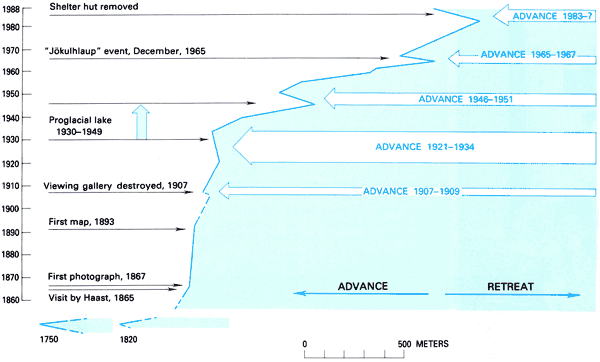
Figure
13.-Historic variations of the terminus position of the Franz Josef Glacier
and associated events.
1907-A viewing gallery giving access across a sheer rock face above the northeast
margin on the snout was scraped off the rock face by this small advance shortly
after being built.
1930-1949-A proglacial lake formed but soon filled with outwash gravels. The
lake was popular for boating until a large ice block, held submerged by debris,
released its load and erupted through the lake surface.
1965-During a heavy rainstorm in December, the main subglacial channel was apparently
blocked beneath the glacier snout, and the accumulated water burst upward through
the glacier to continue downvalley as a spectacular flood wave of water and
ice. There was some damage but no casualties.
1984- A shelter hut, built in 1981 for visitors helicoptered to the inaccessible
southwest edge of the glacier snout, was knocked off of its foundation by a
large ice block that fell from the glacier front, which was advancing at the
rate of a meter per day. The hut was removed from the site, which now remains
well under the glacier.
U.S. Geological Survey,
U.S.Department of the Interior
This page is https://pubs.usgs.gov/prof/p1386h/nzealand/nzfig13.html
Contact: Richard S. Williams, Jr.,
and Jane G. Ferrigno
Last modified 05.04.00