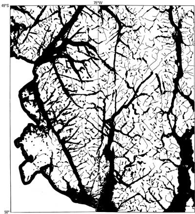
Satellite images show the amazing labyrinth of channels, fjords, and elongated lakes along the Pacific coast of Patagonia, which had been mapped in the Carta Prelíminar of the 1950's. It is strikingly noticeable that the features trend in only three directions: the direction of the Andean ranges and two others at about a 60° angle to the ranges (fig. 56). The two latter directions correspond to the directions of maximum shear stress caused by plate convergence. The orientation of these features probably represents shear zones that have been preferentially scoured by glaciers in the past. It cannot be denied that the entire Pacific continental shelf of Patagonia has been covered by ice in the past: the emerged islands are almost devoid of sedimentary terrane, and the granodiorite batholith is exposed at the surface everywhere.
Figure 56.--Isla Wellington between lat 49° and 50°S. showing that channels and fjords have three preferred orientations. They cannot have been scoured by glacier flow from east to west during glacial epochs. The topography is very rough; steep slopes and rain forest make the island impenetrable. Nevertheless, the elevation does not exceed 1,463 m anywhere.
The bottom of channels and fjords is normally about 200 m below the sea bottom, whereas their shores commonly rise above 1,000 m. The largest measured overdeepening is 1,344 m in Fiordo Baker (approximately 48°S.), which trends east, but a depth of 1,288 m has been measured in the north part of Canal Messier, which trends north between Isla Wellington and other Pacific islands and the continent (fig. 54). This strong glacial erosion seems to indicate that local glaciers and ice fields have existed repeatedly on the Pacific islands and that the ice streams ran in directions other than from east to west. The Northern and Southern Patagonian Ice Fields were often larger than today, but their western outlet glaciers flowed generally in the south to north channels. Today, a negative isostatic anomaly exists on the SPIF and on the Pacific islands but not between them (Kraemer, 1992). This indicates that in the late Pleistocene another ice field was present on the Pacific islands, together with a thicker SPIF. The idea of a single, elongated ice cap, with a convex east-west profile, covering the Patagonian Andes from the limit of the continental shelf to the Argentine pampa must be dismissed.
The glacial history of Patagonia has begun to be deciphered, in particular thanks to the work of the late John Mercer (Mercer, 1968, 1970, 1976; Mercer and Sutter, 1982). More detailed studies, leading to a major revision in the dating of the last morainic system, have been done by Clapperton and others (1995).
Caldenius, in his pioneering work of 1932, recognized an "old glaciation" and a young one (Lliboutry, 1956, p. 421-424). In fact, at least three old glaciations are evident.
Between these main glaciations, smaller ones probably took place. At Cerro del Fraile (just east of Brazo Rico of Lago Argentino), glacial drift alternates with lava flows that are well dated by magnetic reversals. This exposure reveals five glaciations between 2.43 Ma and 1.67 Ma. At that rate, one could speculate at least 40 glaciations in Patagonia.
The youngest glaciation, more or less simultaneous with the Wisconsinan stage in North America and the Weichselian stage in northern Europe, left terminal moraines at or near the east shores of the large piedmont lakes of central Patagonia and the piedmont embayments of southern Patagonia. From north to south, they are Lago Buenos Aires/General Carrera, Lago San Martín/O'Higgins, Lago Viedma, Lago Argentino, Seno Skyring, Seno de Otway, the Strait of Magellan, and Bahía Inútil in Tierra del Fuego (fig. 54). Two distinct systems can be recognized, Caldenius' "third" and "fourth" systems of end moraines, which are better identified by the names of the narrows created by their moraines in the Strait of Magellan: the Primera Angostura (the outer "third" system) and the Segunda Angostura (the inner "fourth" system). The outer system limits the four mentioned lakes, and the inner one limits the Senos Skyring and de Otway and Bahía Inútil. Caldenius' second system, farther to the east, was not confirmed by his successors.
Caldenius thought that the moraines corresponded to the Gotiglacial and Finiglacial stages in Scandinavia (dated at about 18 ka and 10 ka, respectively), but they are older. According to Clapperton and others (1995), the moraines of Segunda Angostura were deposited not at 10 ka but during at least five advances ranging in age from about 70 ka to about 11 ka. The last advance is also documented in the Beagle Channel, near Ushuaia (Heusser and Rabassa, 1987) (figs. 40 and 54). It corresponds to the Younger Dryas in Europe. Nevertheless, around Laguna San Rafael at 11 ka, glaciers were probably smaller than today (Mercer, 1970), a fact that would confirm that the cooling of the Younger Dryas had its origin in the Atlantic Ocean.
During the last glacial maximum at 20-18 ka, the Patagonian ice fields would have been relatively extensive and thick. In fact, only 1 glaciation among maybe 40 earlier glaciations was more extensive, and at the time of the most extensive glaciation at 1.2-1.0 Ma, the "piedmont glacier Argentino" extended only 80 km farther to the east from this last glacial maximum. The extension and thickening of the Patagonian ice fields was probably only slightly less during previous glaciations.
When looking at the FitzRoy group from the northeast, a striking difference is revealed between the lower half of Cerro Eléctrico, smoothed by glacial erosion below about 1,300 m, and its upper part, without any sign of erosion. On its north side in Valle Eléctrico, a glacial terrace exists at 1,300-1,400 m (fig. 36). It confirms that this was the elevation of the surface of an outlet glacier, probably about 80 km long, that discharged ice from the SPIF through Paso Marconi. At Paso Marconi, 10 km upstream, the surface elevation was probably 1,800+-100 m (200-400 m higher than today). The ice stream thinned and locally had a large surface slope as it flowed through Paso Marconi. Consequently, the central part of the ice sheet should have been at 2,100+-200 m (300-700 m higher than today) during the last glacial maximum.
According to a numerical simulation by Hulton and others (1994), the ice-sheet surface would have exceeded 2,700 m. With a maximum width of about 400 km, the bottom drag would have been about 3.6 bar (0.36 megapascal), much too large a value. In fact, the calculation by Hulton and others cannot be trusted at all because it is based on an arbitrary model for the ELA, an isothermal, albeit cold, ice sheet, always at -6°C, and a fanciful topography. In their model, all the relief of the unglaciated land has been smoothed out; all the elevated islands and deep channels have been replaced by a flat, emerged land below 300 m, and all north to south ranges exceeding 1,200 m in height have been erased. With this model, only a large thickness of the ice sheet allows its surface to rise above the ELA. With elevations more than 2,700 m, the ice sheet would have been cold, and the accumulation would have been a weak function of the mean temperature. With elevations of about 2,000 m, the ice sheet would have been temperate as the ice fields are today, and the accumulation would have been a strong function of the mean air temperature because of the changes in the rain-snow limit. Because of the temperate nature of the glacier and this strong function, the lowering of the temperature required to start a glaciation would have been much smaller in Patagonia than in the polar regions.
We may also be skeptical about the changes in the ELA that have been inferred from various "models." Although Hulton and others (1994) claim that their model is grounded on mass and energy balances, it is, in fact, a mere correlation with some meteorological averages. Owing to the rain-snowfall discontinuity, relations are not linear, and averages cannot be used. For instance, Kerr and Sugden (1994) predict activity coefficients of about 0.9 m of ice per 100 m of elevation, whereas in Patagonia, the measured ones are about 1.5 m/100 m.
The story of the late Pleistocene has not been as well studied in continental Patagonia as it has been in the Strait of Magellan by Clapperton and others (1995). On the shores of Lagos Buenos Aires/General Carrera, Viedma, and Argentino, several benches of outwash (kame terraces) can be seen clearly on Landsat imagery. According to Lliboutry (1952) and Mercer (1965), they were formed after the last glacial maximum at 20 ka. If the oscillations of the Pleistocene ice sheet were about the same as those in the Strait of Magellan, the highest terraces might be older than 20 ka.
Climatic changes and terminal moraines of the Holocene are better known. A review of knowledge of that time, and a comparison between Patagonia and western North America, is found in Heusser (1961).
The chronology of Holocene moraines in front of Glaciares Upsala and Tyndall has been established by Aniya and Sato (1995a, b). The moraines were deposited around 3.6 ka, 2.3 ka, 1.4 ka, and 250 years before present. (In the Lakes District, Mercer's (1976) dating of the oldest moraine is different, 4.6-4.2 ka, and the third one is not found.) It is preferable to call the first three epochs of temporary glacier advance "Little Ice Ages" rather than neoglaciations. The last "Little Ice Age" began in Patagonia between A.D. 1614 and A.D. 1600. In Europe and Iceland, it had already started by A.D. 1570, but to the contrary, the climate in Patagonia at the end of the 16th century was much milder. These facts were established in 1993 by María del Rosario Prieto and Herrera in an important work, which unfortunately has not yet been published. These two historians located at the Archives of the Merchant Marine in Seville, Spain, 20 logbooks of ships crossing the Strait of Magellan to or from Valparaíso (fig. 1), 5 from each of the following intervals of time: 1520-26, 1535-58, 1578-99, and 1615-24. Only during the second and third time periods was any mention made of numerous icebergs in the channels and of winds from the northeast. During the period 1578-99, mild northeast winds, quite unusual today, were the most common, and the weather was warm, whereas in the interval 1615-24, the wind blew from the southwest quarter one-half of the time and from the northwest quarter one-third of the time, and the weather was very cold.
The icebergs found in the channels in 1535-58 and 1578-99 were blown there by the northeast winds. In 1615-24, as today, the westerly winds kept the icebergs calved by the SPIF at the far ends of the fjords. To have had winds from the northeast, a high-pressure system must have existed to the south of the ships over the Strait of Magellan. The synoptic situation would have been still more extreme than the one depicted in figure 3C, which is rather unusual today (note in this figure a northeast wind at Comodoro Rivadavia).
Compared with the big climatic change around A.D. 1600, the climatic changes in Patagonia during the two last centuries have been extremely modest. Around the NPIF, dendrochronological studies of Podocarpus nubigemus have been used to infer paleoclimate (Sweda, 1987; Sweda and Inoue, 1987). The only significant change in tree-ring widths during the last 200 years is a very strong increase between 1963 and 1978, uncorrelated with any change in the temperature or precipitation at Puerto Aisén (fig. 54).
This critical review of Patagonian glaciology has a broader scope than that of a mere glacier inventory because now, in 1997, a copious literature has appeared, most of which remains poorly known. Because this review overturns several preconceived ideas, such as the utility of monitoring glacier advances on an annual basis, the synchronism of glaciations and "Little Ice Ages" in the Northern and Southern Hemispheres, and the existence in the past of a single ice sheet covering all Patagonia, investigators in glaciology and in paleoclimates should pay attention to the actual hard facts. Patagonian glaciology poses fascinating problems. This paper stresses the utility of satellite imagery for studies of these problems, not only for periodic mapping of the glaciers.
This review would not have been possible without the aid of many investigators who sent me documents or reviewed the manuscript. Information came from Eduardo García, Cedomir Marangunic, Humberto Peña, and Andrés Rivera (Santiago de Chile); from Mateo Martinic and Gino Casassa (Punta Arenas); from Pedro Skvarca (Buenos Aires); from Arturo Corte, Lydia Espizúa, and María del Rosario Prieto (Mendoza); from several mountain guides in Mendoza and Chaltél; and last but not least, from the two main leaders of glaciological expeditions to Patagonia, Renji Naruse (Sapporo) and Masamu Aniya (Ibaraki). In addition, the Argentine Department of Foreign Affairs kindly offered me a trip to Patagonia and Mendoza in December 1993.
The main documents, of course, were all the Landsat images supplied by the editors. The composite satellite images and perspective views offered by Masamu Aniya and the spectacular photographs given by Pedro Skvarca were very valuable for illustrating the Patagonian ice fields. I thank heartily all these unselfish collaborators.
| Home | Next |
U.S. Geological Survey, U.S.Department of the Interior