Río Pascua, the 50-km-long outlet of Lago San Martín/O'Higgins (see northeast corner of fig. 29), has no name on ONC T-18, in spite of its important discharge (510 m3 s-1). South of Lago San Martín/O'Higgins and Fiordo Calén (top center of fig. 29), the Southern Patagonian Ice Field (SPIF or, in Spanish, Hielo Patagónico Sur) extends more than 330 km between the watersheds of Lagos San Martín/O'Higgins, Viedma, and Argentino (fig. 30) on the east and the fjords of the Pacific Ocean on the west. Its total area (including 1,500 km2 of contiguous glaciers) was 13,500 km2 in 1945, reduced to about 13,000 km2 in 1986. The ice divides between its outlet glaciers, and the equilibrium lines in 1986 have been determined from Landsat TM images by Aniya and others (1996). The number of outlet glaciers in successive ranges of areas is given below.
| Total area (km2) | >1,280 | 1,280-640 | 640-320 | 320-160 | 160-80 | 80-40 | 40-20 | <20 |
| Number of glaciers | 0 | 4 | 7 | 9 | 12 | 13 | 3 | ? |
A description of the Southern Patagonian Ice Field and its outlet glaciers from north to south is as follows (see figs. 29-39).
North of lat 49°S., most of the ice field is a uniform plateau that has only a few nunataks. The main outlet glaciers are Glaciar Jorge Montt (464 km2), flowing northward to Fiordo Calén; Glaciar Bernardo (536 km2), flowing westward to Fiordo Bernardo; Glaciar Greve (438 km2), flowing westward and then southward; and Glaciar O'Higgins (820 km2), flowing eastward to Lago San Martín/O'Higgins (fig. 29). In 1986, the ELA's on these four glaciers were at 950 m, 1,300 m, 1,000 m, and 1,300 m, respectively.
Between lat 49° and 50°S., three parallel north-south ranges about 20 km apart may be recognized (figs. 29, 34). They are not continuous, and the ice fields that fill the north-south valleys between them can escape eastward or westward through some gaps. The central range consists of Cordón Pío XI, which culminates at Cerro (Volcán) Lautaro (3,380 m), and Cordón Mariano Moreno, which culminates at Cerro Francisco Moreno (3,536 m). (One must not confuse the writer and journalist Mariano Moreno (1711-1811) with the expert (perito) of the Comisión de Límites Francisco Moreno (1852-1919). The title of Perito is, therefore, commonly kept in place-names.) Except for the active Cerro (Volcán) Lautaro, this range is made up of metamorphic schists of Paleozoic age that were thrust eastward over sedimentary rocks of Jurassic and Early Cretaceous age (Kraemer, 1992). Therefore, the north-south valleys should be primarily of tectonic, not glacial, origin.
The entire northern part of the ice-filled west valley is part of the accumulation zone of Glaciar Brüggen (1,265 km2), discussed in a special subsection below. It was christened by its discover, Father de Agostini, as Glaciar Pío XI (Agostini, 1945). The official name of Glaciar Brüggen was applied 20 years later. Out of respect for the intention of Father de Agostini, I christened the range nearby as Pío XI (Cordón Lautaro) instead, but the name of Cordón Lautaro has prevailed. The plateau of the accumulation zone was christened Meseta del Comandante by an official Chilean expedition that found an access route to it from Fiordo Exmouth, and it was rechristened Meseta Caupolicán (named after an Araucan hero) by the Instituto de la Patagonia. Farther to the south are Glaciar Penguín (507 km2) and Glaciar Europa (403 km2) (fig. 30).
The east valley is filled by the ice of Corredor Hicken, which flows northward to join Glaciar O'Higgins; by Glaciar Viedma (903 km2), which flows eastward and has a calving front in Lago Viedma (254 m) (fig. 35); and by Glaciar Upsala, flowing southward to a north arm of Lago Argentino (187 m) (figs. 29, 30). The ice divides that separate Corredor Hicken of Glaciar O'Higgins, Glaciar Chico (also calving in Lago San Martín/O'Higgins), and Glaciar Viedma, cannot be determined because the area, known as Meseta de los Cuatro Glaciares (plateau of the four glaciers), is very flat and almost horizontal. The fourth glacier, separated by a very slight sill, is Glaciar Brüggen to the west. Another slight sill separates Meseta de los Cuatro Glaciares from the Glaciar Marconi on the east, at the head of the Río Eléctrico valley (fig. 36). The name Río Eléctrico does not come from electrical storms, which are almost unknown in Patagonia. It is a name given by the local farmers, who compared the noise made by the gusts of the fierce west wind with thunder. The elevation of Meseta de los Cuatro Glaciares is 1,500-1,590 m (Puente Blanco, 1963b), and the ELA on Glaciar Upsala was at 1,150 m in 1986.
The east series of short ranges includes, from north to south, Cordón GAEA, Cordón Marconi, Cordón Torre, and several mountains on the northwest and southwest of Lago Viedma. Cordón Torre is a series of needles culminating at Cerro Torre (3,102 m) (fig. 37). Five kilometers to the northeast, another series of needles culminates at Monte FitzRoy/Cerro Chaltél (3,405 m). Both series of peaks are young intrusive stocks of granite and granodiorite intruded at 10 Ma. Thus, the floor of the very deep valley between the ranges, whose depth ranges from 1,870 m to about 600 m, has been entirely carved by glacial erosion. In February 1952, the ELA on the east glaciers of this group was at 1,250-1,300 m (Lliboutry, 1952). The needles and huge vertical walls of the FitzRoy group (fig. 38) are famous among climbers worldwide (Buscaini and Metzeltin, 1989). They are extremely difficult to climb because of the typically bad weather and very strong winds, as well as the paucity of cracks or zones of fractured rock. The massif has not undergone tectonic stresses, and the maritime climate allows little frost cracking.
At lat 50°24'S., the SPIF is interrupted by two transverse fjords, Fiordo Mayo from Lago Argentino and the northeast arm of Fiordo Peel from the Pacific Ocean (fig. 30). This arm was confused with Fiordo Andrés by F. Reichert when he saw it in the distance from the ice divide, which explains the erroneous name of Seno Andrew found on many maps. The distance between Fiordo Mayo and Fiordo Peel is about 18 km. In the valley between them is a small lake, Laguna Escondida, into which Glaciar Mayo is calving. Sometime between 1970 and 1975, this lake lost about 44 percent of its area by draining off into Fiordo Mayo (Pedro Skvarca, written commun.).
South of this constriction, the SPIF is narrower, without large ice plateaus. The largest glaciers are Glaciar (Perito) Moreno (255 km2), which has a calving front in Lago Argentino (fig. 39), and Glaciares Grey (269 km2) and Tyndall (331 km2), both flowing southward (fig. 30). The ELA on Glaciar Tyndall is at 900 m. Casassa (1992) measured its thickness across a transverse profile using a radio-echosounder. Echoes were no longer obtained beyond 3 km from the glacier's east margin where the ice thickness exceeded 600 m, the maximum range of radio-echosounding in temperate glaciers.
The spectacular Paine group, a young granodioritic intrusion similar to the FitzRoy group, and perhaps even more beautiful, stands between Glaciar Grey and the dry pampa. On a small glacier on the west side of the ice field, Glaciar Olguín, the ELA was at 1,400-1,500 m in 1955 (Luis Krahl, oral commun.). On the southernmost glacier of the SPIF, Glaciar Balmaceda (lat 51°23'S.), the ELA was at 650 m in 1986 (Aniya and others, 1996).
In spite of the lower elevations, mountain glaciers and small ice fields are found along the north-south axis of the Patagonian Andes south of the SPIF. The main ones are listed below. (The source of information is the Carta Prelíminar at a scale of 1:250,000.)
Because of persistent cloudiness, Landsat images of all of this uninhabited region do not exist, as yet, and all of our knowledge comes from aerial photography.

|

|
|
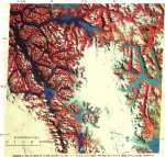
Figure 29.--Northern part of the Southern Patagonian Ice Field. |
Figure 30.--Southern part of the Southern Patagonian Ice Field. |
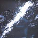
Figure 31.--Oblique color satellite photograph of the Southern Patagonian Ice Field, Chile and Argentina. |

|

|
|
Figure 32A.--Landsat 5, band 4, Thematic Mapper (TM) mosaicked image of the Southern Patagonian Ice Field |
Figure 32B.--False-color composite mosaic of the same images used for A. |
Figure 33.--Landsat 2 false-color composite image of the northern part of the Southern Patagonian Ice Field. |

|
|
|
Figure 34.--View on 11 February 1966 from the summit of Cerro Bertrand showing the three mountain ranges in the middle part of the Southern Patagonian Ice Field. |
Figure 35.--Oblique aerial photograph looking northwest at Glaciar Viedma in the Southern Patagonian Ice Field as it calves into Lago Viedma. |
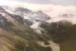
Figure 36.--Head of the valley of the Río Eléctrico, just north of the FitzRoy group. |

|

|

|
Figure 37.--Glaciar Torre in 1967. |
Figure 38A.--FitzRoy-Torre massif from the surface of the Southern Patagonian Ice Field. |
Figure 38B.--View looking west toward the FitzRoy-Torre massif with Monte FitzRoy/Cerro Chaltél on the right and Cerro Torre on the left. |

|

|
|
Figure 39.--View looking west at Glacier (Perito) Moreno from Cerro Buenos Aires. |
Figure 40.--Southwestern Tierra del Fuego. |
| Home | Next |
U.S. Geological Survey, U.S.Department of the Interior