GLACIERS OF SOUTH AMERICA--
GLACIERS OF PERÚ
By BENJAMíN MORALES-ARNAO1
With sections on the CORDILLERA BLANCA ON LANDSAT IMAGERY and QUELCCAYA ICE CAP2By STEFAN L. HASTENRATH3
The glacierized areas of Perú are found in 20 distinct mountain ranges (cordilleras) extending from central northern Perú to its southern border, and they include two major glacier systems. The largest system, which is in the central northern part of Perú in the Cordillera Blanca, extends along a distance of 200 kilometers; it has a total glacierized area of 723.4 square kilometers. The second largest system has a glacierized area of 539 square kilometers and is in the southeastern part of Perú in the Cordillera de Vilcanota. The estimated total ice-covered area within Perú is about 2,600 square kilometers.
The glacierized areas are very important because runoff (meltwater) from glaciers is used for agricultural, industrial, and domestic purposes. Runoff from glaciers is particularly important in the hyperarid coastal areas. On the other hand, some glacierized cordilleras have historically been the sites of catastrophes such as ice avalanches, floods, and the like. In the Río Santa valley, adjacent to the Cordillera Blanca, for example, 22 such catastrophes of glaciological origin have taken place since 1702 and have caused the destruction of towns, villages, and croplands and have killed tens of thousands of inhabitants.
In this century, studies were begun in 1927 for agricultural, industrial, and scientific purposes, and since 1941, studies and construction projects have been undertaken to prevent damage from glacier hazards. The Government of Perú has completed many successful engineering projects that drain glacier lakes in order to reduce the danger of failure and catastrophic flooding. From 1974 to 1984, the Quelccaya ice cap in the Cordillera de Vilcanota, southern Perú, has been intensively studied by Ohio State University, in cooperation with Peruvian institutions, in order to determine paleoclimatic conditions. In addition, a national inventory of the glaciers of Perú was finished in 1988 by the Department of Glaciology and Hydrology of Hidrandina S.A.
Perú is located on the western side of South America between lat 0° and 18°S. and long 69° and 81°W.; it is traversed by the great Andean mountain system that extends along the entire western side of South America (Peterson, 1958; Ricker, 1977). Extensive areas of this mountain system are glacierized. The Peruvian Andes comprise three major ranges or cordilleras: Cordillera Occidental on the west, Cordillera Central in the middle, and Cordillera Oriental on the east (fig. 1). The high average elevation of the three cordilleras, together with regional and local climatic conditions, has resulted in the extensive development of glaciers in many locations (Heim, 1947; Morales Arnao, C., 1953-1995, 1964; Morales Arnao, B., 1969c; Francou, 1984). In fact, the Peruvian Andes have the largest area of tropical glaciers on Earth (Mercer, 1967; Kinzl, 1968). The total ice-covered area is estimated to be 2,600 km2 (Hidrandina,1988). The average minimum elevation of glaciers in Perú is 4,800 m above sea level (asl). In the discussion that follows, the glacierized areas have been grouped into 20 distinct cordilleras (Morales Arnao, C., 1964) (fig. 2, table 1). Each of these areas is briefly described, first those in the Cordillera Occidental followed by those in the Cordillera Central and then those in the Cordillera Oriental. Within each cordillera, the areas are described from north to south. The largest single glacier, the Quelccaya ice cap, is in the Cordillera de Vilcanota. Of the next 11 largest glaciers, 8 are located in the Cordillera Blanca (table 2).
Figure 1.--Principal cordilleras of the Andes Mountains in Perú.
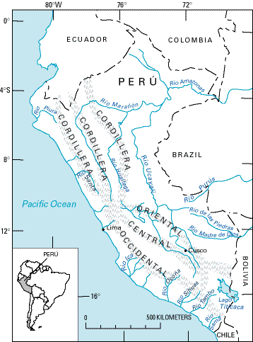
Table 1.--Location, orientation, and area of the principal glacierized areas of Perú
[Abbreviations: N, north; W, west; E, east]
|
Cordillera (see fig. 2) |
Latitude |
Longitude |
Ice-covered area |
Extent (kilometers) |
Highest elevation (meters above mean sea level) |
Drainage basin |
Data source |
|
|---|---|---|---|---|---|---|---|---|
|
Blanca |
08°08'-09°58' |
77°00'-77°52' |
723.40 |
200 |
NW |
6,768 |
Pacific-Atlantic |
1 |
|
Huallanca |
09°52'-10°03' |
76°58'-77°04' |
22.41 |
19 |
NW |
5,480 |
Pacific-Atlantic |
1, 2 |
|
Huayhuash |
10°11'-10°26' |
76°50'-77°00' |
88.11 |
26 |
NW |
6,634 |
Pacific-Atlantic |
1, 2 |
|
Raura |
10°21'-10°31' |
76°41'-76°50' |
57.03 |
20 |
NW |
5,727 |
Pacific-Atlantic |
1, 2 |
|
|
|
|
|
|
|
|
|
|
|
La Viuda |
10°33'-11°37' |
76°07'-76°42' |
28.5 |
130 |
NW |
5,780 |
Pacific-Atlantic |
1, 2 |
|
Central |
11°37'-12°26' |
75°30'-76°18' |
176.3 |
100 |
N |
5,817 |
Pacific-Atlantic |
1 |
|
Chonta |
12°37'-13°07' |
75°00'-75°30' |
42 |
50 |
N |
5,305 |
Pacific-Atlantic |
3 |
|
Huanzo |
14°30'-15°01' |
72°50'-73°15' |
158 |
57 |
NW |
5,445 |
Pacific-Atlantic |
3 |
|
|
|
|
|
|
|
|
|
|
|
Chila |
15°02'-15°26' |
71°43'-72°37' |
52 |
80 |
E |
5,556 |
Pacific-Atlantic |
2, 3 |
|
Ampato |
15°24'-15°51' |
71°51'-73°00' |
105 |
140 |
E |
6,426 |
Pacific |
2, 3 |
|
Volcánica |
16°07'-16°33' |
71°12'-71°33' |
15 |
50 |
NW |
6,100 |
Pacific |
2, 3 |
|
Barroso |
16°51'-17°37' |
69°45'-70°30' |
20 |
110 |
NW |
5,741 |
Pacific |
2, 3 |
|
|
|
|
|
|
|
|
|
|
|
Huaytapallana |
11°47'-11°56' |
75°00'-75°05' |
35 |
17 |
NW |
5,720 |
Atlantic |
3 |
|
Vilcabamba |
13°10'-13°27' |
72°30'-73°15' |
173 |
85 |
E |
6,271 |
Atlantic |
3 |
|
La Raya |
15°10'-15°26' |
70°36'-71°14' |
88 |
60 |
E |
5,489 |
Pacific-Atlantic-Titicaca |
2, 3 |
|
Huagaruncho |
10°14'-10°19' |
75°57'-76°03' |
48 |
10 |
E |
5,879 |
Atlantic |
2, 3 |
|
Urubamba |
13°08'-13°17' |
71°58'-72°16' |
23 |
30 |
NW |
5,750 |
Atlantic |
2, 3 |
|
Vilcanota |
13°39'-14°29' |
70°31'-71°20' |
539 |
120 |
N, W |
6,384 |
Atlantic |
3 |
|
|
|
|
|
|
|
|
|
|
|
Carabaya |
14°00'-14°22' |
69°38'-70°19' |
75 |
NW |
5,780 |
Atlantic-Titicaca |
2, 3 |
|
|
Apolobamba |
14°35'-14°45' |
69°14'-69°34' |
100 |
35 |
E |
5,852 |
Atlantic-Titicaca |
2, 3 |
|
|
|
Total |
102 |
|
|
|
|
|
|
|
|
|
2,596 |
|
|
|
|
|
1 Data from Peruvian glacier inventory. Source: vertical aerial photographs.
2 Data published in Revista Peruana de Andinismo.
3Data from Landsat images.
Figure 2.--Distribution of the 20 glacierized cordilleras of Perú shown in green and the location of some of the principal rivers. Abbreviation: R., Río.
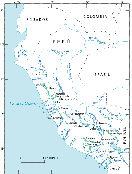
Table 2.--Principal glaciers of Perú
|
Cordillera |
Name |
Latitude south |
Longitude west |
Area (square kilometers) |
Maximum length or diameter (kilometers) |
Type of glacier |
|---|---|---|---|---|---|---|
|
Vilcanota |
Quelccaya |
14°00' |
70°46' |
54.00 |
17.0 |
ice cap |
|
Blanca |
Copap |
09°17' |
77°20' |
13.76 |
7.0 |
plateau |
|
Huayhuash |
Yerupaja |
10°14' |
76°55' |
9.36 |
6.0 |
valley |
|
Blanca |
Chopicalqui |
09°05' |
77°36' |
9.10 |
6.5 |
valley (debris-covered) |
|
Blanca |
Pucahirca |
08°53' |
77°35' |
6.50 |
4.5 |
plateau |
|
Blanca |
Artesonraju |
08°58' |
77°38' |
5.97 |
3.6 |
mountain |
|
Central |
Sullcon |
11°52' |
76°03' |
5.43 |
5.3 |
valley |
|
Blanca |
Cook |
09°02' |
77°39' |
5.39 |
4.6 |
valley (debris-covered) |
|
Blanca |
Safuna |
08°51' |
77°37' |
4.69 |
3.6 |
valley |
|
Raura |
Santa Rosa |
10°29' |
76°44' |
2.36 |
2.7 |
valley |
|
Blanca |
Uruashraju |
09°35' |
77°19' |
2.15 |
2.5 |
valley |
|
Blanca |
Yanamarey |
09°39' |
77°16' |
1.30 |
1.7 |
valley |
Manuscript approved for publication 18 March 1998.
1Consult Control S.A., Avenida Javier Prado Este 210-4to. Piso B San Isidro, Lima, Perú.
2 The names in this section conform to the usage authorized by the U.S. Board on Geographic Names in its Gazetteer of Peru (U.S. Board on Geographic Names, 1989). The names not listed in the gazetteer are shown in italics, with the exception of Perú for which the Peruvian spelling is retained.
3 Department of Atmospheric and Oceanic Sciences, University of Wisconsin, 1225 West Dayton Street, Madison, Wis. 53706 U.S.A.
| Home | Next |
U.S. Geological Survey, U.S.Department of the Interior