Good quality, cloud-free Landsat imagery is available for many of the glacierized areas of Perú (table 7 and fig. 15). However, the use of satellite imagery is somewhat limited for studying small mountain-type glaciers or areas that are obscured by shadows in high-relief regions. Where available, satellite imagery acquired during dry periods at the end of the melt season is particularly useful because it shows glacier margins that are not masked by snowpack.
Landsat images have been used to make a general inventory of the glaciers of Perú on which this report is based. Photographic prints at a scale of 1:1,000,000 or enlarged to a scale of 1:250,000 were used to estimate the glacier area and were especially useful for several cordilleras that are not covered by aerial photography (table 1). Newer satellite systems that have increased resolution will provide even more accurate information in the future.
Figure 15.--Optimum Landsat 1, 2, and 3 images of the glaciers of Perú.
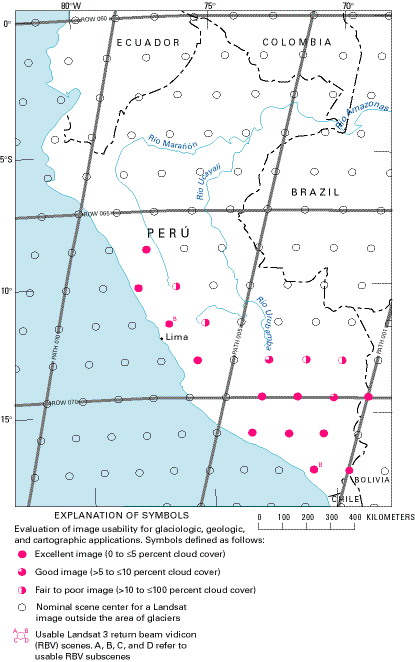
Table 7.--Optimum Landsat 1, 2, and 3 images of the glaciers of Perú
[See fig. 15 for explanation of symbols used in "code" column]
|
Path-Row |
Nominal scene center (lat-long) |
Landsat identification number |
Date |
Solar elevation angle (degrees) |
Code |
Cloud cover (percent) |
Remarks |
|---|---|---|---|---|---|---|---|
|
1-70 |
14°26'S. |
2187-13565 |
28 Jul 75 |
37 |
|
0 |
Cordillera Apolobamba. Image used for figure 10 |
|
1-72 |
17°19'S. |
2151-13581 |
22 Jun 75 |
33 |
|
0 |
Cordillera del Barroso. Image used for figure 7 |
|
1-72 |
17°19'S. |
277216-13350 |
04 Aug 77 |
32 |
|
0 |
Archived in Brazil |
|
2-69 |
12°59'S. |
2188-14021 |
29 Jul 75 |
38 |
|
20 |
Band 6 |
|
2-70 |
14°26'S. |
2188-14024 |
29 Jul 75 |
37 |
|
10 |
Cordillera de Vilcanota |
|
2-71 |
15°52'S. |
2170-14032 |
11 Jul 75 |
34 |
|
0 |
Cordillera La Raya |
|
2-72 |
17°19'S. |
2206-14025 |
16 Aug 75 |
38 |
|
0 |
Nevado Arundane, Cordillera del Barroso |
|
2-72 |
17°19'S. |
31183-13584, Subscene B |
31 May 81 |
33 |
|
0 |
Landsat 3 RBV, Nevado Arundane, Cordillera del Barroso. Image archived by USGS-GSP* |
|
3-69 |
12°59'S. |
2531-14012 |
06 Jul 76 |
35 |
|
30 |
|
|
3-70 |
14°26'S. |
2135-14085 |
06 Jun 75 |
36 |
|
0 |
Cordillera de Vilcanota, Cordillera de Huanzo |
|
3-71 |
15°52'S. |
2279-14073 |
28 Oct 75 |
55 |
|
0 |
Nevado Ampato and Cordilleras Chila and Volcánica |
|
4-69 |
12°59'S. |
2190-14134 |
31 Jul 75 |
38 |
|
10 |
Cordilleras Vilcabamba and Urubamba |
|
4-70 |
14°26'S. |
22116-14134 |
07 Nov 80 |
55 |
|
0 |
Cordillera de Huanzo |
|
4-71 |
15°52'S. |
22116-14141 |
07 Nov 80 |
55 |
|
0 |
Nevado Ampato |
|
6-68 |
11°33'S. |
2156-14251 |
27 Jun 75 |
37 |
|
30 |
Cordillera Central area |
|
6-69 |
12°59'S. |
2156-14254 |
27 Jun 75 |
36 |
|
0 |
Southern Cordillera Central, Cordillera de Chonta |
|
7-67 |
10°06'S. |
2445-14254 |
11 Apr 76 |
45 |
|
30 |
Cordilleras Huayhuash, Raura, Huagaruncho |
|
7-68 |
11°33'S. |
2175-14304 |
16 Jul 75 |
38 |
|
30 |
Southern part of Cordillera La Viuda and western Cordillera Central |
|
7-68 |
11°33'S. |
2139-14310 |
10 Jun 75 |
38 |
|
0 |
|
|
7-68 |
11°33'S. |
31224-14271, Subscene B |
11 Jul 81 |
37 |
|
0 |
Landsat 3 RBV. Image archived by USGS-GSP* |
|
8-66 |
08°40'S. |
2194-14351 |
04 Aug 75 |
42 |
|
0 |
Cordillera Blanca. Image used for figure 4 |
|
8-67 |
10°06'S. |
2518-14294 |
23 Jun 76 |
37 |
|
0 |
Southern Cordillera Blanca |
*USGS-GSP is the U.S. Geological Survey-Glacier Studies Project.
| Home | Next |
U.S. Geological Survey, U.S.Department of the Interior