GLACIERS OF SOUTH AMERICA --
GLACIERS OF VENEZUELA
The glaciers of Venezuela consist of five cirque glaciers situated on three peaks (Pico Bolívar, 5,002 meters; Pico Humboldt, 4,942 meters; and Pico Bonpland, 4,893 meters) in the Sierra Nevada de Mérida and encompass an area of 2 square kilometers. The present-day glacier area covers only about 1 percent of the 200-square-kilometer area covered in the Sierra Nevada during the late Pleistocene Mérida Glaciation. The total glacier-covered area in the Cordillera de Mérida during this glaciation was approximately 600 square kilometers. Rapid deglaciation has taken place in the Sierra Nevada in the last century, a process that has accelerated since 1972.
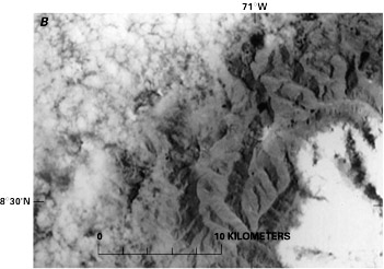
The Sierra Nevada de Mérida3 is part of the largest massif in Venezuela, the Cordillera de Mérida, which is part of the northern extent of the Cordillera de los Andes (Andes Mountains) (figs. 1 and 2). The Sierra Nevada includes the highest peak in Venezuela, Pico Bolívar, which has an elevation of 5,002 m.
Similar to other high mountain systems in temperate and tropical regions, this area was affected by Quaternary glaciation. The last ice advance in this area, which was at its maximum about 20,000 years before present (B.P.) and ended about 13,000 years B.P., was called the Mérida Glaciation. The glacierized area in the Cordillera de Mérida was approximately 600 km2; this included the following high areas from southwest to northeast: Páramo de Tamá, Páramo Batallón, Páramo Los Conejos, Páramo Piedras Blancas, and Teta de Niquitao. Approximately 200 km2 of the total glacierized area was in the Sierra Nevada de Mérida, and of that amount, the largest concentration, 50 km2, was in the areas of Picos Bolívar, Humboldt (4,942 m), and Bonpland (4,893 m). Moraines from the Mérida Glaciation are found between 2,600 and 3,500 m above sea level (asl). Since that time, deglaciation has been widespread. Probable "Little Ice Age" moraines have been found at 4,200 m asl, but at present, the snowline is above 4,700 m asl. As a result, the only glaciers currently in existence in Venezuela are five cirque glaciers of approximately 2 km2 in total area on Picos Bolívar, Humboldt, and Bonpland, tiny remnants of the former extent of Pleistocene ice (Schubert 1974, 1975, 1987; Schubert and Clapperton, 1990) (fig. 3).
The most important early references to the Venezuelan glaciers are those by Sievers (1886, 1908, 1911) and Jahn (1912a, b, 1925, 1931). These reports (reviewed by Schubert, 1980, 1984) include maps, data, and photographs that can be compared with present-day glacier conditions. More recent reports are those of Schubert (1972, 1980, 1984, 1992) and Giegengack and Grauch (1975). The reports by Schubert present comparative data on glacier retreat between the mid-19th century and 1991, data that strongly suggest a reduction of more than 95 percent of the glacier-covered area during that interval of time. The American Geographical Society also compiled information on the glaciers of the northern Andes in three publications (Fuchs, 1958; Field and associates, 1958; Lehr, 1975).
Figure 1.--The Sierra Nevada de Mérida in northwestern Venezuela. Broken lines show general area of Cordillera de Mérida.
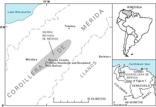
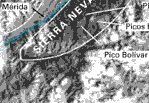
Figure 2.--Annotated Landsat 2 MSS image showing the location of glaciers in the Sierra Nevada de Mérida.
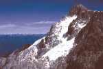
Figure 3.--Small cirque glaciers on Pico Bolívar.
The earliest published map of the Sierra Nevada de Mérida was based on field work by Jahn in 1910 (Jahn, 1925). The Jahn map was the only map showing the distribution of glaciers in the Sierra Nevada de Mérida until maps were published by Schubert (1972, 1980, 1984). The Schubert maps are based on vertical aerial photographs acquired in 1952, the only ones available so far for this region. The glacierized area was mapped by the author of this paper on 1:100,000-scale maps by reconstructing the extent of the 1952 glacier from the aerial photographs (approximate scale 1:40,000) and field observations; area measurements were made by the use of a Maho No. 80 planimeter. A comparison of the glacierized area in 1910 mapped by Jahn and in 1952 mapped by Schubert is shown in figure 4 (no effort was made to compare them quantitatively because Jahn did not specify how he mapped the glaciers; this author's estimate, based on planimetric measurements, is that they covered more than 10 km2 in 1910). The map by Jahn shows two broad areas covered by glaciers (Picos Bolívar-Espejo-La Concha and Picos Humboldt-Bonpland) and also a small glacier on the northwest flank of Pico El Toro, about 4.5 km west of Pico Espejo. The topographic accuracy of Jahn's map (originally at a scale of 1:100,000) is estimated on the basis of a comparison with the Cartografía Nacional (1977) map no. 5941 at the same scale of +-0.5 km.
Figure 4.--Comparison of areas covered by glaciers in the Sierra Nevada de Mérida in 1910 and 1952. Elevations of peaks are given in figure 5, except for Pico Espejo (4,765 m) and Pico El Toro (4,727 m). Elevations are in meters above mean sea level; contour interval, 200 m. Base maps: Cartografía Nacional, Caracas, nos. 5941 and 6041, scale 1:100,000. Arrows show direction of drainage.
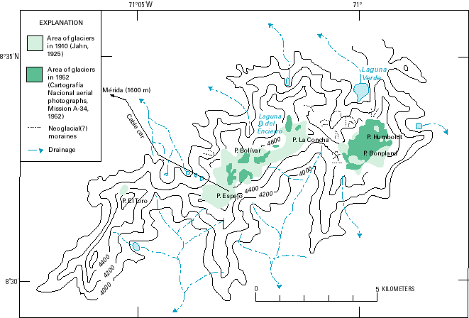
Figure 5 shows the latest map of the Sierra Nevada de Mérida glaciers (modified after Schubert, 1980) based on the 1952 vertical aerial photographs. Table 1 gives the areas of the glaciers measured by the author.
Figure 5.--Distribution of glaciers (green areas) in the Sierra Nevada de Mérida in 1952. The numbers identify glaciers listed in table 1. Data derived from Cartografía Nacional aerial photographs, Mission A-34, 1952. Base maps: Cartografía Nacional, Caracas, nos. 5941-I-SE and 6041-IV-SO, scale 1:100,000. Elevations are in meters above mean sea level; the contour interval is 100 m.
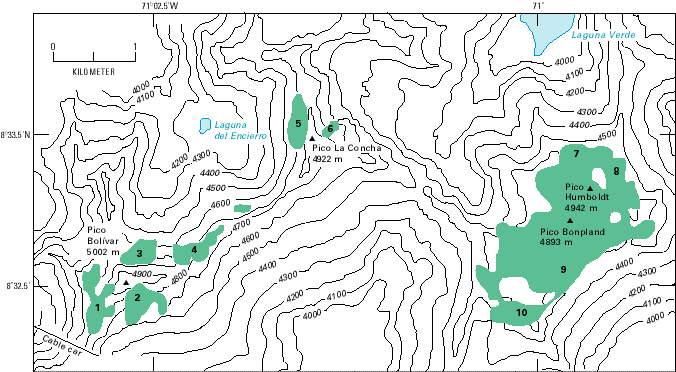
Table 1.--Names of the glaciers in the Sierra Nevada de Mérida, measurements based on 1952 aerial photography, and recent changes
|
Massif |
Glacier1 |
Area in 19522 (square kilometers) |
Appearance in 19913 |
|---|---|---|---|
|
Pico Bolívar |
Espejo (1) |
.27 |
Melted into 2 small firn patches |
|
|
Timoncito (2) |
.17 |
Almost completely disappeared |
|
|
El Encierro (3) |
.17 |
Lost at least 50 percent of its area |
|
|
El Encierro (4) |
.10 |
Retreated |
|
Pico La Concha (8°33.5'N., 71°01.5'W.) |
Ño Leon (5) |
.10 |
Completely disappeared |
|
|
Coromoto west remnant (6) |
.07 |
Completely disappeared |
|
Picos Humboldt/Bonpland |
Coromoto east remnant (7, 8) |
2.03 |
Retreated4 |
|
|
Sinigüis (9) |
Retreated |
|
|
|
Nuestra Señora (10) |
Completely disappeared |
|
|
|
Total |
2.91 |
Approx. 2.00 km 2 |
1 Number in parentheses refers to number on figure 5.
2 Measured by author by use of a planimeter on maps modified with data from 1952 vertical aerial photographs; approximate scale, 1:40,000.
3 Based on field work and ground photographs from 1991 (Schubert, 1992).
4 Based on the Landsat image shown in figure 6A (2372-14164; 29 January 1976).
The only aerial photographs available for the Sierra Nevada de Mérida are those that were taken for the Dirección de Cartografía Nacional (Caracas), Mission A-34 (nos. 972 to 982), in 1952 at an approximate scale of 1:40,000. These photographs are the primary source of data used to compile the latest glacier map (fig. 5).
Not many Landsat images have been acquired of the Sierra Nevada de Mérida area. Only 18 Landsats 1, 2, and 3 multispectral scanner (MSS) images are archived at the EROS Data Center, Sioux Falls, S. Dak., and many of these are covered by clouds. The best early Landsat image obtained of the Sierra Nevada de Mérida glaciers is a Landsat 2 image (2372-14164) that was acquired on 29 January 1976. Figure 6A shows an annotated enlargement of MSS band 7 of that image. Two other early Landsat images of the area (listed in table 2) are cloud free but have slightly more snow cover. The most useful Landsat 4 and 5 MSS scenes were acquired in February 1985 and March 1991 (see table 2). Both show substantially less snow-and-ice cover than the 1976 image. The March 1991 image, which coincides closely with the author's 1991 visit to the area, confirms the major retreat described in table 1 and by Schubert (1992). A 1:250,000-scale enlargement of the 1991 scene is shown in figure 6B for comparison.
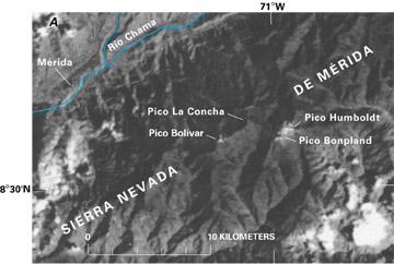
Figure 6.--Enlarged 1:250,000-scale Landsat images showing the Sierra Nevada de Mérida glaciers.
A, Annotated Landsat 2 MSS image. Compare with figures 5 and 6B. The town of Mérida is indicated. Landsat 2 image (2372-14164, band 7; 29 January 1976; Path 6, Row 54) from EROS Data Center, Sioux Falls, S. Dak.
B, Landsat 5 MSS image. In spite of some clouds, it is possible to see that the glaciers have substantially retreated. Landsat 5 MSS image (52580-14204, band 4; 25 March 1991; Path 6, Row 54) from EROS Data Center, Sioux Falls, S. Dak.
In the enlarged 1976 Landsat MSS image (fig. 6A), the outline of the Picos Humboldt and Bonpland glaciers can be discerned. All other glaciers show as white spots, principally because of the relatively small area of glacierization (about 3 km2). In the enlarged 1991 MSS image (fig. 6B), it is clear that the glaciers on Pico La Concha have disappeared. The glaciers on Pico Bolívar are so small that seeing them is almost impossible. The glaciers on Picos Humbolt-Bonpland are visible but greatly reduced in size. Figure 7 is an index map showing the location and coverage of the optimum Landsat imagery.
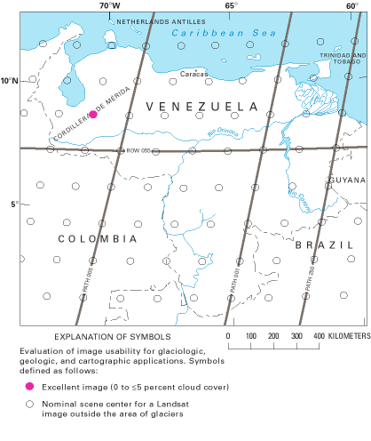
Figure 7.--Optimum Landsat 1, 2, and 3 images of the glaciers of Venezuela.
Table 2. -- Optimum Landsat 1, 2, and 3 images of the glaciers of Venezuela
[See fig. 7 for explanation of symbols used in "Code" column]
|
Path-Row |
Nominal scene center (lat-long) |
Landsat identification number |
Date |
Solar elevation angle (degrees) |
Code |
Cloud cover (percent) |
Remarks |
|---|---|---|---|---|---|---|---|
|
6-54 |
08°40'N. 70°38'W. |
2372-14164 |
29 Jan 76 |
42 |
|
0 |
Pico Bolívar, Pico La Concha, Pico Humboldt, and Pico Bonpland glaciers; image used for figures 2, 6 |
|
6-54 |
08°40'N. 70°38'W. |
21434-14055 |
26 Dec 78 |
40 |
|
0 |
Pico Bolívar, Pico La Concha, Pico Humboldt, and Pico Bonpland glaciers |
|
6-54 |
08°40'N. 70°38'W. |
31385-14195 |
19 Dec 81 |
40 |
|
0 |
|
|
Selected Landsat 4 and 5 images |
|||||||
|
6-54 |
08°41'N. 70°29'W. |
50356-14293 |
20 Feb 85 |
48 |
|
0 |
Pico Bolívar, Pico La Concha, Pico Humboldt, and Pico Bonpland glaciers |
|
6-54 |
08°41'N. 70°29'W. |
52580-14204 |
25 Mar 91 |
52 |
|
10 |
Pico Bolivar, Pico La Concha, Pico Humboldt, and Pico Bonpland glaciers; image used for figure 6 |
Early reports and paintings can be used to determine the approximate location and extent of the glaciers in the Sierra Nevada de Mérida in the mid- to late-1800's. A comparison of these sources with present-day conditions indicates that a rapid retreat has taken place during the last 100 years (Schubert, 1980, 1984, 1987). The amount of retreat can be estimated by comparing the mapping of the glaciers by Jahn in 1910 (fig. 4) with the mapping and analysis by this author using 1952 data (figs. 4 and 5). The glaciers in the Sierra Nevada de Mérida, estimated to cover 200 km2 during the Pleistocene (Schubert, 1972, 1984), were approximately 10 km2 in 1910 and about 3 km2 in 1952 (Schubert, 1972, 1980). However, the 1952 area was probably somewhat larger than indicated by these figures because the high slope angle of the glacier surfaces was not taken into account when the measurements were made. In addition, the accuracy of the measurements also is affected by the distortion within the aerial photographs caused by the rugged topography.
Since 1952, ground photographs and fieldwork have documented a significant retreat of the glaciers; the recession is particularly evident since 1972 (Schubert, 1992). Of the 10 glaciers mapped in 1952, 4 have completely or almost completely disappeared, 1 has disintegrated into firn patches, and the remaining 5 are substantially smaller (see table 1). Although it is not possible to quantify the difference exactly, the remaining glacier area is now probably less than 2 km2. This type of rapid retreat is also found in other parts of South America; such as Colombia, Ecuador, and Perú.
Cartografía Nacional, 1977, Map sheets 5941 and 6041: Caracas, República de Venezuela Ministerio de Obras Públicas, Dirección de Cartografía Nacional, scale 1:100,000.
Defense Mapping Agency, 1993, Gazetteer of Venezuela, names approved by the U.S. Board on Geographic Names: Washington, D.C., Defense Mapping Agency, v. 1 and 2, 701 p.
Field, W.O., and associates, 1958, Glaciers of Middle America, map no. 4, in Atlas of mountain glaciers in the Northern Hemisphere: Natick, Mass., U.S. Army, Quartermaster Research and Engineering Command Headquarters, Quartermaster Research and Engineering Center, Environmental Protection Research Division, Technical Report EP-92, scale 1:20,000,000.
Fuchs, I.M., 1958, Glaciers of the northern Andes, in Geographic study of mountain glaciation in the Northern Hemisphere: New York, American Geographical Society, pt. 3, chap. 4, 14 p.
Giegengack, Robert, and Grauch, R.I., 1975, Quaternary geology of the central Andes, Venezuela: A preliminary assessment: Boletín de Geología (Venezuela), Publicación Especial 7, v. 1, p. 241-283.
Jahn, A., 1912a, La cordillera Venezolana de los Andes [The Andean Cordillera of Venezuela]: Caracas, Revista Técnica del Ministerio de Obras Públicas, p. 1-40.
------1912b, Mis ascensiones a la Sierra Nevada de Mérida [My ascents to the Sierra Nevada de Mérida]: Caracas, El Cojo Illustrado, no. 497, p. 466-474.
------1925, Observaciones glaciológicas en los Andes venezolanos [Glaciological observations in the Venezuelan Andes]: Caracas, Cultura Venezolana, no. 64, p. 265-280.
------1931, El deshielo de la Sierra Nevada de Mérida y sus causas [The deglaciation of the Sierra Nevada de Mérida and its causes]: Caracas, Cultura Venezolana, no. 110, p. 5-15.
Lehr, Paula, 1975, Glaciers of the northern Andes, in Field, W.O., ed., Mountain glaciers of the Northern Hemisphere: Hanover, N.H., U.S. Army Corps of Engineers, Cold Region Research and Engineering Laboratory, v. 1, p. 479-490.
Schubert, Carlos, 1972, Geomorphology and glacier retreat in the Pico Bolívar area, Sierra Nevada de Mérida, Venezuela: Zeitschrift für Gletscherkunde und Glazialgeologie, v. 8, no. 1-2, p. 189-202.
------1974, Late Pleistocene Mérida Glaciation, Venezuelan Andes: Boreas, v. 3, no. 4, p. 147-151.
------1975, Glaciation and periglacial morphology in the northwestern Venezuelan Andes: Eiszeitalter und Gegenwart, v. 26, p. 196-211.
------1980, Contribución de Venezuela al inventario mundial de glaciares [Venezuelan contribution to the World Glacier Inventory]: Caracas, Boletín de la Sociedad Venezolana de Ciencias Naturales, v. 34, no. 137, p. 267-279.
------1984, The Pleistocene and recent extent of the glaciers of the Sierra Nevada de Mérida, Venezuela: Stuttgart, Erdwissenschaftliche Forschung, v. 18, p. 269-278.
------1987, La extensión de los glaciares pleistocenos en la Sierra Nevada de Mérida [The extent of Pleistocene glaciers in the Sierra Nevada de Mérida]: Caracas, Boletín de la Sociedad Venezolana de Ciencias Naturales, v. 41, no. 144, p. 299-308.
------1992, The glaciers of the Sierra Nevada de Mérida (Venezuela), a photographic comparison of recent deglaciation: Erdkunde, v. 46, p. 58-64.
Schubert, Carlos, and Clapperton, C.M., 1990, Quaternary glaciation in the northern Andes (Venezuela, Colombia and Ecuador): Quaternary Science Reviews, v. 9, p. 123-125.
Sievers, W., 1886, Über Schneeverhältnisse in der Cordillere Venezuelas [On snow conditions in the Venezuelan Cordillera]: Jahresbericht der Geographischen Gesellschaft in München, 1885, p. 54-57.
------1908, Zur Vergletscherung der Cordilleren des tropischen Südamerikas [Glaciation of the Cordillera of tropical South America]: Zeitschrift für Gletscherkunde, v. 2, no. 4, p. 271-284.
------1911, Die heutige und die frühere Vergletscherung Südamerikas [Present-day and past glaciation in South America]: Leipzig, Vogel Verlag, Sammlung Wissenschaftlicher Vorträge, Heft 5, p. 1-24.
Manuscript approved for publication 18 March 1998.
1 Instituto Venezolano de Investigaciones Científicas, Apartado 21827, Caracas 1020A, Venezuela.
2 Deceased on 22 July 1994.
3 The names used in this section are approved by the U.S. Board on Geographic Names (Defense Mapping Agency, 1993) with the exception of Sierra Nevada de Mérida, a name in common use that is used here to identify that part of the Cordillera de Mérida that has snow or ice cover.
| Home | Glaciers of Colombia | Volume Contents |
U.S. Geological Survey, U.S.Department of the Interior