
PRE-1980 TEPHRA-FALL DEPOSITS ERUPTED FROM MOUNT ST. HELENS, WASHINGTON
By Donal R. Mullineaux
U. S. Geological Survey Professional Paper 1563
Tephra Layer D
About 1,200 years ago, explosions at the site of Sugar Bowl dome on the
northeast flank of Mount St. Helens produced a single layer of tephra as well as pyroclastic flows and lahars (Crandell
and Mullineaux, 1978; Mullineaux and Crandell, 1981; Crandell and Hoblitt, 1986; Crandell, 1987). The tephra consists
of gray, dacitic, moderately vesicular blocks, bombs, lapilli, and ash. Most large clasts are close to the vent
and were thrown along ballistic trajectories. Ash, however, was carried at least 30 km downwind by air currents
(Crandell and Hoblitt, 1986). The layer is strongly lenticular and where thick forms a conspicuous coarse stratum
on and near the volcano. Over most of the areal extent of the ash, however, it is thin and obscure.
Layer D is unstratified but moderately well sorted. Most fragments are vesicular,
but vesicles are small and the fragments are relatively dense. Carbonized wood fragments are common; twigs that
were converted to charcoal in place with needles still attached were recovered from the deposit. In most places
layer D has a thin oxidized soil zone in its upper part, and a thin, discontinuous mat of carbonized vegetation
is common at its top.
Hypersthene and hornblende were the only ferromagnesian phenocrysts identified
in most samples of layer D dacite. Scattered fragments of nonvesicular dacite in the deposit contain cummingtonite,
hornblende, and biotite and these fragments may have been derived from preexisting deposits of Ape Canyon age (Crandell
and Hoblitt, 1986).
Two samples of dacite associated with layer D contained approximately 69 percent
SiO2, the highest silica values of any Mount St. Helens tephra analyzed.
Diagnostic features
Layer D is easily distinguished from the underlying set B by color, dacitic
composition, and ferromagnesian minerals. It is very similar to the overlying layer Wn, but is thinner, more lenticular,
darker gray, and characterized by denser pumice. The thin soil zone in the upper part of layer D and the carbonaceous
material at its top also help to distinguish layer D from Wn.
Stratigraphic relations
Over its known range, layer D overlies brown scoria of set B. It is overlain
everywhere by the compositionally similar layer Wn. The contact between the two is obscure but is marked by the
thin soil and carbon-rich zone at the top of layer D.
Distribution and thickness
Layer D is limited to the northeast flank of the volcano and downwind toward
the northeast (Crandell and Hoblitt, 1986) (fig. 55). Its maximum known thickness is
about 40 cm only 3 km from the vent, where it includes bombs as large as 50 cm across. Downwind to the northeast,
scattered lapilli 1 cm or more across are present in ash for at least 25 km (fig. 55)
(Crandell and Hoblitt, 1986). Layer D clasts commonly have diameters larger than the layer is thick, and they project
above the top of the associated ash matrix. This characteristic is especially conspicuous where the layer is thin
near its margins; along these margins, the layer commonly appears as a line of small clasts rather than as a continuous
stratum.
|
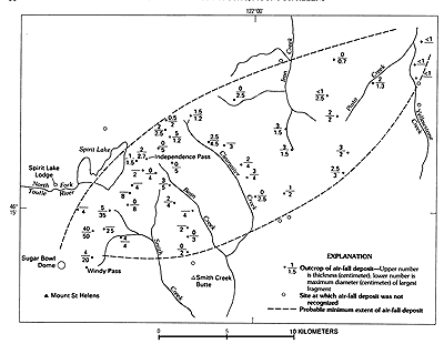
Figure 55. Inferred distribution of tephra layer D of Sugar Bowl age. Modified from Crandell (1987, p.
64). (33K)
|
Origin
Layer D formed by at least two explosive eruptions at the site of Sugar
Bowl dome (Crandell and Hoblitt, 1986, p. 32). Its grain size and distribution indicate that it consists partly
of fragments carried along ballistic trajectories and partly of particles carried downwind by air currents.
Age
Layer D overlies set B tephra that probably is as young as about 1,700 years
old and underlies set W tephra erupted in A.D. 1480. Its postulated age of about 1,200 years is based on one charcoal
sample from the tephra deposit that has a radiocarbon age of about 1,150 years (W-2993, table
2), and a second sample from an associated pyroclastic-flow deposit that has a radiocarbon age of about 1,200
years (W-5343, table 2).
Tephra Set W
Set W consists of two thick, white layers of pumice lapilli and bombs and
at least three thinner layers (figs. 56, 57). Because the
two thick layers extend in different directions, generally only one is conspicuous at any single site (figs.
3, 58). The set forms a conspicuous, light-colored stratigraphic unit between the
darker sets B and X. Pumice makes up most of set W; lithic fragments are common but are subordinate in both major
layers. Strata of the set appear almost unweathered.
|
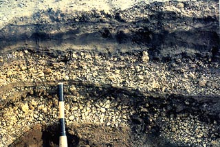
Figure 56. Tephra set W about 10 km east-northeast of volcano in a direction along which layers Wn and
We overlap, along USFS Road 94 in the north-central part of sec. 28, T. 9 N., R. 6 E. Tape bands on pickhandle
are 10 cm wide. Photograph taken in 1989. (149K)
|
|
Figure 57. Composite columnar section of tephra set W, Mount St. Helens. (16K)
|
Lapilli and bombs in set W generally are only in the sector east of a north-south
line through the volcano. Elsewhere, the tephra consists of ash. Toward the west, ash beds of the same age locally
contain lapilli, but they are probably chiefly deposits of ash clouds and pyroclastic flows. Because pyroclastic-flow
deposits are virtually limited to the western side of the volcano and identified tephra layers confined to the
east, the stratigraphic relations of the two kinds of deposits are not well known.
|
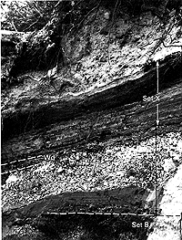
Figure 58. Tephra set W about 8 km east of Mount St. Helens. At this location the only conspicuous pumice
layer is We. Photograph taken in 1983. (95K)
|
Composition
Highly vesicular pumice makes up most of the set. Lithic fragments generally
make up about 5-20 percent of fragments in the two large-volume layers, but they are about equal in abundance with
pumice in smaller volume layers. Ferromagnesian minerals in pumice from all layers are almost entirely hypersthene
and hornblende; only a few fragments of other ferromagnesian minerals were found.
Hypersthene in set W has a higher refractive index than hypersthene in other
Mount St. Helens dacitic pumice. In set W, the lowest refractive indexes measured were distinctly above 1.70 and
near 1.71. In contrast, the lowest indexes of hypersthenes measured from other pumice deposits from Mount St. Helens
are lower than 1.70.
Seven samples from set W show a range of SiO2 of about 66-67 percent.
Thus set W pumice is higher in silica than all other Mount St. Helens deposits except pumice from the Sugar Bowl
dome.
Diagnostic features
Northeast, east, and southeast of the volcano, set W is easily recognized
because it contains a thick pumice layer that is coarse, almost white, and virtually unweathered. Its color readily
distinguishes it from the underlying, dark set B, and it is much coarser than the next older set P. In some places,
set W is similar in thickness and grain size to set Y, but it is easily distinguished from set Y and from other
older pumiceous sets except set J by its ferromagnesian mineral suite.
The thick layers of set W are similar to the younger layer T but differ in
ferromagnesian mineral composition. Moreover, the higher refractive index of hypersthene can be used to distinguish
set W pumice from all other hypersthene-hornblende pumices from Mount St. Helens.
Stratigraphic relations
Near the volcano, set W overlies a soil zone developed mostly in set B;
carbonized wood is widespread at the top of the soil zone. Farther downwind, set W generally overlies a soil zone
developed in older Mount St. Helens tephras or in deposits of other origins.
Set W is overlain by set X, and no physical evidence of a time lapse was seen.
In many places lapilli of the overlying layer Xb fell alongside scattered lapilli of the topmost layer of set W,
forming an apparent stratigraphic unit that includes clasts of the two different sets.
Distribution and thickness
Recognized tephra deposits of set W crop out from approximately north of
the volcano clockwise around to slightly west of south. Because its thickness and grain size are determined mostly
by the thicknesses of layers Wn and We, set W is coarsest and thickest primarily toward the northeast and secondarily
toward the east. At the northeast base of the volcano, it is as thick as 200 cm and consists mostly of lapilli
and bombs. At 20 km toward the northeast, it is about 100 cm thick (fig. 59). Toward
the east and southeast, the set also consists chiefly of one lapilli layer between ash beds (figs.
48, 58) and is about 20 cm thick at 10 km. Toward the south, the set consists of
lapilli and ash 5-10 cm thick at a distance of 10 km.
|
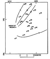
Figure 59. Thickness (in centimeters) of tephra set W, Mount St. Helens. (9K)
|
No tephra layers were identified among the ash deposits in the stratigraphic
position of set W west of the volcano. Much and probably most of the ash of that age there is likely of flowage
origin.
Mostly because of layers Wn and We, set W is an excellent stratigraphic marker.
Layer Wn has been recognized toward the northeast across Washington and into Canada for more than 400 km (Westgate
and Fulton, 1975; Smith and others, 1977). Layer We has been recognized across southern Washington and into Idaho
(Smith and others, 1977), also at a distance of more than 400 km. Although the ferromagnesian mineral content and
general chemical composition of set W are not unusual for Cascade tephras, the refractive index of constituent
hypersthene, chemical composition of glass, and closely known age of these layers make them especially useful time-stratigraphic
marker beds.
Age
Set W was erupted about 500 years ago, as first determined by tree-ring
studies on glacial moraines in Mount Rainier National Park (Crandell, 1969). During the 1980's, growth-ring studies
of trees showed that layers Wn and We probably were erupted in A.D. 1480 and 1482, respectively (Yamaguchi, 1983).
All of set W was erupted within a few tens of years, and perhaps within just
a decade. The closest limiting date for the end of the set is from the age of a tree rooted in the overlying set
X, which provides a 30-year maximum time for eruption of set W (Yamaguchi, 1993). Allowance for time between the
first eruptions of set X and establishment of the tree suggests that set W might well have been erupted in less
than 10 years.
Description of layers in set W
Five layers in set W, each traceable for at least several kilometers northeast
of the volcano, are separately described (figs. 56, 60;
measured section W-1). Two other lapilli beds that may represent additional eruptions are present locally at the
northeast base of the volcano, but they could not be traced and are not separately described.
|
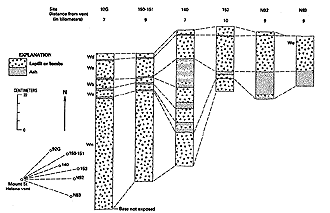
Figure 60. Columnar sections of set W from northeast to southeast of Mount St. Helens and diagram of
their locations relative to the central vent of the volcano. (28K)
|
Flowage deposits of the same age as set W are abundant on the west and southwest
flanks of the volcano; they are mostly west of the recognized limits of the named tephra layers. Thin ash probably
deposited by ash clouds also is present northeast of the volcano, both as a bed between the two uppermost layers
of the set and as matrix ash in those layers.
Measured section W-1.
Near nose of east-trending spur between forks of Smith Creek, 0.65 km southeast of northwest corner of sec.
30, T. 9 N., R. 6 E. See figure 63.
| |
|
Thickness
(centimeters) |
| 10. |
Layer Xb. Scoria lapilli in ash |
1 |
| Set W |
|
|
| 9. |
Layer Wd. Pumice and lithic lapilli, in about equal proportion, in predominantly pinkish-brown ash |
3 |
| 8. |
Ash, pinkish-brown |
1 |
| 7. |
Layer We. Lapilli and small bombs, chiefly pumice, in sparse ash; contains bombs as large as 9 by 8 by 5 cm, largest
at top of layer;
small lithic lapilli concentrated near base |
8 |
| 6. |
Ash, brownish-gray |
<1 |
| 5. |
Layer Wb. Pumice and lithic lapilli in ash; pumice lapilli larger, as much as about 4 cm across; openwork texture |
5 |
| 4. |
Ash, brownish-gray |
0.5 |
| 3. |
Layer Wa. Lithic and pumice lapilli and small bombs in ash; lithic clasts dominant but pumice clasts are larger,
as much as 6 cm across; coarsest in middle of layer; openwork texture |
5 |
| 2. |
Ash, brownish-gray |
1 |
| 1. |
Layer Wn. Lapilli and bombs, mostly pumice: lithic clasts about 5-10 percent; locally crudely layered: openwork;
bombs as much as 12 by 10 by 9 cm |
>60 |
| Base covered |
|
|
Layer Wn
The coarse, thick layer Wn forms the base of set W in a broad band that
trends northeast from the volcano. It is a single, well-sorted deposit of highly vesicular, almost unweathered,
yellowish-white pumice containing scattered lithic fragments. Locally, layer Wn shows crude bedding but generally
is not stratified or noticeably graded. Hypersthene and hornblende make up its ferromagnesian mineral suite; measured
ratios range from about 10:1 to 2:1 (Smith and Leeman, 1982; Mullineaux, 1986). Generally, that ratio is higher
than hypersthene-hornblende ratios for other tephras that contain the same ferromagnesian minerals. Whole-rock
Si02contents measured for pumice from layer Wn range from about 66.5 to 68.5 percent.
The unweathered nature of pumice in layer Wn and its thickness, coarse grain
size, and stratigraphic position near the surface generally distinguish the layer from all tephra deposits except
layer T. Layer Wn can be distinguished from layer T locally by greater thickness and grain size and generally by
stratigraphic position and ferromagnesian mineral content.
In most places, the white pumice of layer Wn lies on a brown soil developed
in set B. Locally, toward the northeast, thin deposits of the Sugar Bowl eruptions intervene between set B and
layer Wn. Layer Wn is overlain by younger tephra layers of set W everywhere except toward the north, where it is
overlain directly by set X.
Layer Wn forms a thick lobe that bears about 035 degrees from the volcano (fig. 61). On the volcano flank, layer Wn is as thick as 200 cm and contains bombs as much
as 50 cm in length and 30 cm across. At 20 km, it consists of as much as 100 cm of lapilli and a few bombs in ash.
The layer decreases to 5-10 cm of mostly coarse ash at about 100 km from the volcano and to about 1 cm of finer
ash at 400-450 km where it crosses the border between northeastern Washington and Canada (Smith and others, 1977,
p. 215).
|
 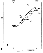
Figure 61. Thickness (in centimeters) of layers in tephra set W, Mount St. Helens. A, Layer Wd. B, Layer
We. C, Layer Wb. D, Layer Wa, E, Layer Wn. (28K)
|
Layer Wn is a readily identified and closely dated marker bed. Tree-ring studies
indicate that the eruption occurred after the growing season of A.D. 1479 and before the growing season of A.D.
1480 (Yamaguchi, 1985). For simplicity, A.D. 1480 has been used as the date of eruption (Yamaguchi, 1985). Although
a recent study of ash tentatively correlated with layer Wn on the basis of depth proposes an eruption date of A.D.
1479 (Fiacco and others, 1993), the date of A.D. 1480 is used herein.
Layer Wn of this report was initially called layer W at Mount Rainier (Crandell
and others, 1962). It also makes up the bulk of the pumice described by Carithers (1946) as "the younger pumice
sheet."
Layer Wa
Layer Wa is a single thin bed of lapilli, ash, and a few bombs (fig.
62). Abundant fresh, gray lithic fragments make up about half or slightly more of the deposit. The layer typically
contains clasts that are larger in diameter than the layer is thick (fig. 62). In composition,
it is similar to other layers in set W. Identification of layer Wa is based mostly on its stratigraphic position,
its high proportion of lithic fragments, and the present of clasts that are large relative to the layer thickness.
|
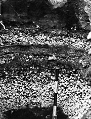
Figure 62. Tephra set W about 11 km northeast of Mount St. Helens, where layer Wa contains large lapilli
but layer Wb does not. Tape bands on pickhandle are 10 cm wide. Photograph taken in 1989. (100K)
|
Layer Wa is everywhere underlain by layer Wn, separated only by thin ash. It
is separated from the overlying layer Wb by similar thin ash.
Layer Wa was identified only northeast of the volcano. Its maximum known thickness
is 5-10 cm at distances of 5-10 km (fig. 61); it was not identified beyond about 12
km. Because of its similarity to the more extensive layer Wn, it probably is not an important marker bed farther
downwind.
The abundance of fresh lithic fragments in layer Wa suggests that a plug or
dome of the same composition as set W was present before eruption of that tephra. This dome was fragmented in part
by an explosive eruption of gas-charged magma to produce the mix of lithic and pumice clasts in layer Wa.
Layer Wb
Layer Wb is another single thin deposit of lapilli, ash, and a few bombs
(fig. 63) on and near the northeast flank of the volcano. Locally, it contains at least
two coarse zones or beds. Layer Wb contains many fresh gray lithic fragments, although they probably are less abundant
than in layer Wa. Ferromagnesian minerals in layer Wb are almost all hypersthene and hornblende, similar to other
tephra layers in set W. Thus, this layer is identified chiefly on the basis of grain size and stratigraphic position.
|
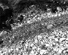
Figure 63. Tephra set W about 8 km northeast of the center of Mount St. Helens. Both layers Wa and Wb
contain large lapilli. Photograph taken in 1983. (137K)
|
Layer Wb is separated from the underlying layer Wa, and also from the overlying
layer We, only by thin ash.
Throughout its known extent, layer Wb is similar in thickness to layer Wa (fig.
61). At 5-10 km from its source, its maximum thickness is only 5-10 cm, and it was traced only to about 12 km.
Its grain size is somewhat smaller than that of layer Wa, and it generally does not contain bombs as large as those
in layer Wa.
Similar to layer Wa, layer Wb probably originated from an explosive eruption
that produced fresh magma as well as fragments from a preexisting dome.
Layer We
Layer We forms a well-defined single stratum of highly vesicular white pumice
lapilli (fig. 58) east of the volcano. It contains many fresh and a few weathered lithic
fragments; fresh lithic fragments are common and locally make up as much as about 30 percent of the layer. Both
crude stratification and grading are present but not conspicuous. Hypersthene and hornblende make up almost its
entire ferromagnesian mineral suite, similar to other layers of set W, and the silica content of its pumice is
also similar. Microprobe analyses of glass, however, have shown minor differences in proportions of potassium,
calcium, and iron in pumice from layers Wn and We and have been used to distinguish between the two (Smith and
others, 1977).
East of the volcano, layer We is relatively easy to differentiate from other
tephra layers of set W on the basis of grain size and thickness. To the east-northeast where its lobe overlaps
that of layer Wn, it is identified by its stratigraphic position.
Toward the east and south, layer We overlies ash of set W that lies in turn
on set B. It is overlain by younger ash of set W and in turn by set X. Farther north, layer We typically overlies
layer Wb, separated only by ash, and is overlain by layer Wd or set X. Locally, pinkish-brown ash, perhaps of ash-cloud
origin, is present in the upper part of layer We and between it and layer Wd.
Layer We forms a relatively broad lobe from northeast of the volcano around
to the south. It is thickest toward the east, where it is as thick as 60 cm and consists mostly of lapilli at 5
km from the vent. Downwind to the east, it is 20-30 cm thick at a distance of 10 km and contains lapilli as much
as 5 cm across and is 10-20 cm thick at 20 km and contains lapilli as much as 2 cm across.
Layer We forms another important marker bed for young stratigraphic sequences
across southern Washington into Idaho. Smith and others (1977) reported that layer We in Idaho about 450 km from
the volcano was "an undisturbed 1 cm layer in peat."
Tree-ring studies indicate that eruption of layer We occurred late in A.D.
1481, or in A.D. 1482 (Yamaguchi, 1982), two years after eruption of layer Wn. For simplicity, the year A.D. 1482
is used for the eruption date of layer We.
Layer Wd
Layer Wd is a widespread, thin stratum of pumice and lithic lapilli, bombs,
and ash (fig. 56). It probably consists of two or more overlapping thin beds north
and east of the volcano. It is similar in mineral content and chemical composition to other layers in set W. Coarse
clasts in layer Wd commonly are embedded in pinkish-brown ash and also are locally underlain and overlain by such
ash. Similar to layer Wa, many of the clasts of layer Wd are larger in diameter than the layer is thick, and they
extend above the level of matrix ash.
Layer Wd is identified by its stratigraphic position at the top of set W, and
its coarse grain size relative to layer thickness.
Throughout its extent, layer Wd is underlain by older layers of set W and overlain
by set X. The upper contact is poorly defined. In places layer Wd does not form a continuous deposit and is not
overlain by an ash bed that clearly separates it from the overlying layer Xb. In some of those places, scoria clasts
of layer Xb have dropped down between scattered lapilli of layer Wd and form a commingled deposit that looks much
like a single stratigraphic unit.
Layer Wd was identified from the north-northeast of Mount St. Helens clockwise
around to the east (fig. 61); it was not traced beyond about 15 km from the volcano.
It is thickest to the northeast, where it is about 5 cm thick at 5-10 km. From there, it thins southward, then
thickens again directly east of the volcano. A second, thinner bed extending toward the east suggests that the
deposit was erupted in at least two different pulses and carried in slightly different directions.
The layer probably resulted from more than one explosive, short-lived eruption
that ejected lapilli and bombs as well as ash. Pinkish-brown ash in the layer may have been derived from ash clouds
associated with pyroclastic flows generated by the same eruptions.
Reworked pumice lapilli deposits
Thick deposits of pumice similar in grain size and thickness to layer Wn
but stratigraphically higher crop out on the volcano's north flank and at several sites in one area about 12 km
north of the mountain. These deposits probably originated from erosion and subsequent redeposition of lapilli of
layer Wn. They form well-sorted deposits that are similar to the primary tephra layer. Rounding of some constituent
lapilli suggests reworking, as does a limited lateral extent for a deposit of its thickness.