
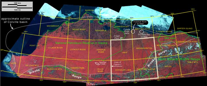
Figure 1. False-color composite Landsat image of northern Alaska showing quadrangles discussed in text and approximate outline of the Colville basin (dashed white line). New geologic maps are being prepared jointly by the U.S. Geological Survey and the Alaska Department of Natural Resources, Division of Geological and Geophysical Surveys and Division of Oil and Gas for many of the quadrangles. Boundaries for the National Petroleum Reserve in Alaska (NPRA), the Arctic National Wildlife Refuge (ANWR), and the ANWR 1002 area are shown in green, dotted lines. See Bird and Houseknecht (2001, 2002) for additional information regarding ANWR and NPRA, including explanation of ANWR 1002 area. Area outlined in white is shown in greater detail in figure 2. Image compiled by U.S. Geological Survey, Earth Resources Observation Systems (EROS) Data Center, Sioux Falls, S. Dak. PRINT/VIEW a high-quality PDF image |
U.S. Department of the Interior, U.S. Geological Survey
URL: https://pubsdata.usgs.gov/pubs/pp/p1673/thumbnails/fig1.html
Maintained by Eastern Publications Group
Last modified: 16:05:00 Thu 01 Dec 2016
Privacy statement | General disclaimer | Accessibility