

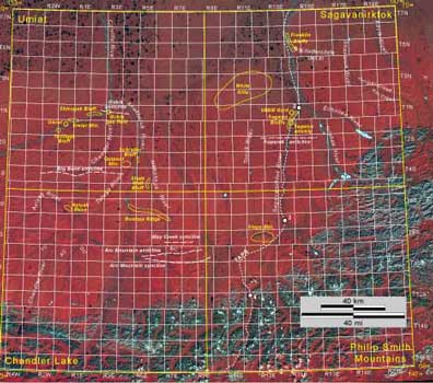
Figure 2. False-color composite Landsat image of the Umiat, Sagavanirktok, Chandler Lake, and Philip Smith Mountains quadrangles, northern Alaska, showing township-range grid, streams, and other features mentioned in text and figure captions. Recent geologic investigations in these quadrangles provided the basis for revisions of Cretaceous and Tertiary stratigraphic nomenclature presented in this paper. TAPS, Trans-Alaska Pipeline System; numbered white dots, TAPS pump stations with pump station number; AC, Autumn Creek; DC, Desolation Creek; MC, May Creek; TC, Torok Creek. Image compiled by U.S. Geological Survey, Earth Resources Observation Systems (EROS) Data Center, Sioux Falls, S. Dak. PRINT/VIEW a high-quality PDF image |
U.S. Department of the Interior, U.S. Geological Survey
URL: https://pubsdata.usgs.gov/pubs/pp/p1673/thumbnails/fig2.html
Maintained by Eastern Publications Group
Last modified: 16:05:04 Thu 01 Dec 2016
Privacy statement | General disclaimer | Accessibility