U.S. Geological Survey Scientific Investigations Map 2817-A
Version 1.0 - 2004
Version 1.1 - 2005
Version 1.2 - 2006
Version 1.3 - 2007
1Alaska Division of Oil
and Gas, Anchorage, AK 99501.
2U.S. Geological Survey, Reston, VA 20192.
3Alaska Division of Geological and Geophysical Surveys, Fairbanks,
AK 99709.
 |
This geologic
map of the Umiat quadrangle is a compilation of previously published USGS
geologic maps and unpublished mapping done for the Richfield Oil Corporation.
Geologic mapping from these three primary sources was augmented with additional
unpublished map data from British Petroleum Company. This report incorporates
recent revisions in stratigraphic nomenclature. Stratigraphic and structural
interpretations were revised with the aid of modern high-resolution color
infrared aerial photographs. The revised geologic map was checked in the
field during the summers of 2001 and 2002. The geologic unit descriptions
on this map give detailed information on thicknesses, regional distributions,
age determinations, and depositional environments. The paper version of this map is available for purchase from the USGS Store.
Readme file [23-KB PDF file] SIM 2817–A [12.9-MB PDF file] GIS data package [22.3-MB ZIP file; ArcGIS 9.X geodatabase]
|
|
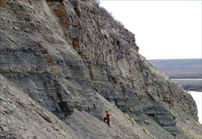
| Upper Cretaceous strata exposed near the axis of Umiat anticline. View is looking eastward at Umiat Mountain along the Colville River (visible at lower right) in Alaska. Strata in lower half of exposure are dark-gray shales and interbedded, light-colored tuffs of the Seabee Formation. Massive beds near top of exposure are sandstones of the Tuluvak Formation. Contact between the Seabee and Tuluvak Formations is gradational, defined by increasing content of sandstone upward. |

![]() U.S. Department of the Interior |
U.S. Geological Survey
U.S. Department of the Interior |
U.S. Geological Survey
URL: https://pubsdata.usgs.gov/pubs/sim/2004/2817a/index.html
For more information, contact David
W. Houseknecht or Christopher P. Garrity
Maintained by Publishing Services
Page Last Modified: 17:04:25 Thu 01 Dec 2016