

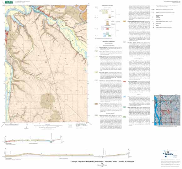
This geologic map of the Ridgefield quadrangle shows Miocene lava flows of the Columbia River Basalt Group and younger sedimentary deposits in the northern part of the Portland Basin of southwestern Washington. The 13 geologic units are represented by colored polygons on the map. These polygons show the distribution of the rock units on the surface of the earth in this area. The map also contains 2 cross sections, a diagram that shows relative age correlation of the map units, an extensive description of those units and other symbols used on the map, and an index map. A more comprehensive description of the map units and other explanatory information can be found in the accompanying pamphlet. This map is one spatial representation of data contained in the accompanying database. |
| File
Name |
File
Type and Description |
File
Size |
| | ||
| FILES for VIEWING and PLOTTING |
||
| PDF file of the 22-page Geology pamphlet containing description of map | 1 MB |
|
| PDF file of 48" x 36" map sheet that can be used for viewing map in a browser, as well as for plotting (geologic map, description of map units, and correlation of map units) | 25.7 MB |
|
| JPG file of 10" x 8" 300 dpi version of the map sheet that can be used for viewing map in a browser or printing on letter-sized paper | 1.5 MB |
|
| README |
||
| PDF readme file that explains the contents of the two data files | 160 KB |
|
| DATA |
||
| Zipped file that contains geodatabase data objects (including metadata) | 11.2-MB file that opens into a 37.4-MB folder |
|
| Zipped file that contains the shapefile package | 4.6-MB file that opens into an 12.1-MB folder |
|
For questions about the content of this report, contact Russ Evarts
Version history| Help
| PDF help
| Publications main page | Western Scientific Investigations Maps | This report is available via print on demand.
| Department of the Interior
| U.S. Geological Survey |
URL of this page: https://pubs.usgs.gov/sim/2004/2844/
Maintained by: Michael Diggles
Date created: November 17, 2004
Date last modified: July 22, 20055 (mfd)