

Introduction
Sandy Canyon Wash, Bitter Seeps Wash, and Bulrush Wash are the principal drainages in the map area that flow south into Kanab Creek, the principal drainage of this region that flows south toward the Colorado River in Grand Canyon. Moccasin Mountain and Moquith Mountain (Moki Mountain on old maps) form highland plateaus west and north of Moccasin and Kaibab, Arizona. The Vermilion Cliffs are a prominent topographic expression of the landscape that marks the southern and eastern edges of Moccasin and Moquith Mountains. The north edge of the map area abuts the Utah/Arizona State line. Access to the map area is by Arizona State Highway 389 and a short paved road to Pipe Spring National Monument and the towns of Kaibab and Moccasin, Arizona. Several unimproved dirt roads lead from these paved roads to various locations within the map area, but travel on some of these roads requires 4-wheel-drive vehicles. Extra food and water are highly recommended for travelers to this remote area. The Kaibab-Paiute Tribe manages the reservation lands that encompass most of the map area. Visitors to the Kaibab-Paiute Indian Reservation are required to obtain a permit and permission from the Tribal Offices at the junction of Highway 389 and the road to Pipe Spring National Monument. The Bureau of Land Management (BLM), Arizona Strip Field Office in St. George, Utah, manages BLM lands west and south of the Kaibab-Paiute Indian Reservation area. Part of the BLM Cottonwood Point Wilderness area is included in the northwest corner of the map. There are 22 sections of land belonging to the State of Arizona and 26 sections of private ranch land, which includes the town of Moccasin, Arizona. Elevations range from about 4,265 ft at Bulrush Wash in the southeast corner of the map area to about 7,042 ft on Moquith Mountain, northeast edge of map area. Elevations below 5,000 ft generally support a sparse growth of sagebrush, cactus, grass, and various high-desert shrubs. Elevations above 5,000 ft commonly support moderate to thick growths of sagebrush and grass in alluvial valleys, while pinion pine, juniper, and oak trees thrive on Moccasin and Moquith Mountains. Salt cedar (tamarisk) and Russian olive trees grow along the banks of local tributary washes east of Kaibab and Moccasin, Arizona. |
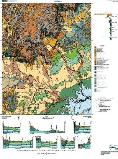 |
| Page-size version of geologic map of Pipe Spring National Monument and the western Kaibab-Paiute Indian Reservation |
| File
Name |
File
Type and Description |
File
Size |
| README files and METADATA |
||
| Readme file that gives information about the digital database |
8 Kb |
|
| Text file of the FGDC-compliant metadata |
32 Kb |
|
| DATA |
||
| Compressed tar file of the digital database for this map |
7.2 MB (expands to 27.1 MB) |
|
| Shapefiles and a style file to facilitate use of the data in ArcMap and other applications |
7.5 MB (expands to 11.6 MB) |
|
| ArcMap style for map colors and symbolization | 544 KB |
|
| FILES
for VIEWING and PLOTTING |
||
| PDF file of pamphlet to accompany this map | 272 KB | |
| MS-Word .doc file of pamphlet to accompany this map | 208 KB | |
| PDF file of map sheet that can be used for viewing map in a browser, as well as for plotting (can also be opened and edited in Adobe Illustrator) | 20.2 MB |
|
For questions about the content of this report, contact George Billingsley
Download a current version of Adobe Reader for free
| Help
| PDF help
| Geopubs main page |
| Western Scientific Investigations Maps |
| Geologic Division |
Earth Surface Processes |
This report is available via print on demand.
Database disclaimer: This database, identified as USGS Scientific Investigations Map 2863, has been approved for release and publication by the Director of the USGS. Although this database has been subjected to rigorous review and is substantially complete, the USGS reserves the right to revise the data pursuant to further analysis and review. Furthermore, it is released on condition that neither the USGS nor the United States Government may be held liable for any damages resulting from its authorized or unauthorized use.
| U.S. Geological Survey | Privacy Statement | Disclaimer | Accessibility |
URL of this page: https://pubs.usgs.gov/sim/2004/2863/
Maintained by: Michael Diggles
Created: December 17, 2004
Last modified: September 12, 2006 (mfd)