In the past 130 years, 11 large (M>6.5) historical earthquakes in the Basin and Range province of the Intermountain
West have produced documented surface ruptures, the majority of which
have occurred in the north-south-trending Central Nevada seismic belt.
Slip rates on individual normal-slip faults in the province are low compared
to the rates on faults associated with plate boundaries, such as those
in California. Nevertheless, these low-slip, normal faults can pose a
significant seismic hazard, especially in urbanized areas such as the
Wasatch Front in Utah, and the eastern side of the Sierra Nevada Mountains
in western Nevada and eastern California.
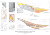
The purpose of this map and report is to provide a basic description of the Eastgate
fault study and to release the field data that were collected during
our study. Much of this detailed information is inappropriate for publication
in professional journals, so we use this large-format map and report
as a means to release these details to the scientific community. By design,
this report contains minimal interpretation of the fault’s late Quaternary
movement history; this history will be the subject of a future report
in a scientific journal.
|
