
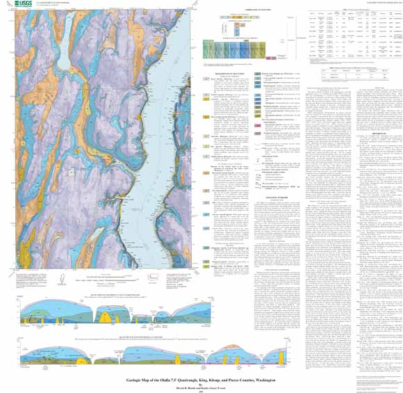
This quadrangle, which lies almost exactly in the center of the Puget Lowland, displays the broad range of geologic environments typical of the region. The upland plain is fluted by the passage of the great continental ice sheet that last covered the area about 17,000 years ago. The plain is cut by channel deposits, both late-glacial and postglacial in age, and it is cleaved even more deeply by one of the major arms of Puget Sound, the Colvos Passage, which here separates the west coast of Vashon Island from the Kitsap Peninsula. Beneath the deposits of the last ice sheet is a complex sequence of older Quaternary-age sediments that extends about 400 meters below the modern ground. The older sediments typically are compact, having been weighted down by one or more episodes of glaciation subsequent to their deposition. Some also are cemented by iron and manganese oxides and hyrdroxides, a consequence of many tens or hundreds of thousands of years of weathering and groundwater movement. |
| File
Name |
File
Type and Description |
File
Size |
| | ||
| FILES for VIEWING and PLOTTING |
||
| PDF file of 36" x 36" map sheet that can be used for viewing map in a browser, as well as for plotting (geologic map, description of map units, and correlation of map units) | 14.8 MB |
|
| JPG file of 8" x 8" 324 dpi version of the map sheet that can be used for viewing map in a browser or printing on letter-sized paper | 3.3 MB |
|
| README |
||
| PDF readme file that explains the contents of the two data files | 432 KB |
|
| DATA |
||
| Metadata | 64 KB |
|
| Zipped file that contains geodatabase data objects | 9.9-MB file that opens into a 80.8-MB folder |
|
| Zipped file that contains the shapefile package | 4.3-MB file that opens into an 11.7-MB folder |
|
For questions about the content of this report, contact Derek Booth at the University of Washington
Version history| Help
| PDF help
| Publications main page | Western Scientific Investigations Maps | This report is available via print on demand.
| Department of the Interior
| U.S. Geological Survey |
URL of this page: https://pubs.usgs.gov/sim/2005/2902/
Maintained by: Michael Diggles
Date created: October 18, 2005
Date last modified: October 18, 2005 (mfd)