Publication - Scientific Investigations Map
In cooperation with the Confederated Salish and Kootenai Tribes of the Flathead Nation
|
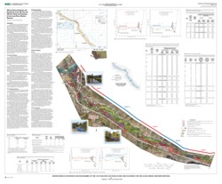
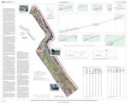
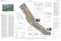
IntroductionThe Jocko River flows across the Flathead Indian Reservation in western Montana and provides irrigation water for several thousand acres of hay and grain that are produced throughout the Jocko River valley. The Jocko River also is an important trout fishery and a tributary to the Flathead River. Much of the agricultural land along the Jocko River is being considered for residential and commercial development. This development has the potential to affect the Jocko River and the fishery. In addition, proposed levee modifications and stream-restoration work could further affect the Jocko River channel and its aquatic habitat. The Confederated Salish and Kootenai Tribes of the Flathead Nation (CSKT) needed information for assessing the effects of proposed development and stream-restoration work on the Jocko River channel and fishery. The potential for increased development and stream-restoration work highlighted the need for a better understanding of the boundaries of the 100-year and 500-year floods. To that end, the U.S. Geological Survey (USGS), in cooperation with CSKT, conducted hydrologic and hydraulic analyses of the Jocko River to identify areas along the river that are subject to flooding. This report presents water-surface elevation data for flood discharges having recurrence intervals of 100 and 500 years and depicts mapped flood and floodway boundaries. The flood boundaries show the extent of flooding under existing (1999-2001) conditions from flood discharges having recurrence intervals of 100 and 500 years. The mapped floodway boundaries show the area within the boundaries of the 100-year flood discharge that is reserved for the passage of flood flows under Montana Administrative Rule 36.15.502. The hydrologic analysis is based on recorded annual-peak discharge data for various years from 1907 to 1998 at four streamflow-gaging stations within or near the study area that extends from the fish hatchery near Arlee to the mouth of the Jocko River near Dixon. The hydraulic analysis is based on channel- and bridge-geometry data collected between 1999 and 2001. |
Sheet 1 (1.96 mb PDF) |
Sheet 2 (1.46 mb PDF) |
Sheet 3 (1.64 mb PDF) |
For additional information contact: |
Document Accessibility: Adobe Systems Incorporated has information about PDFs and the visually impaired. This information provides tools to help make PDF files accessible. These tools convert Adobe PDF documents into HTML or ASCII text, which then can be read by a number of common screen-reading programs that synthesize text as audible speech. In addition, an accessible version of Acrobat Reader 7.0 for Windows (English only), which contains support for screen readers, is available. These tools and the accessible reader may be obtained free from Adobe at Adobe Access. |
| AccessibilityFOIAPrivacyPolicies and Notices | |
 |
|