
|
Published in commemoration of the 100th anniversary of the 1906 earthquake
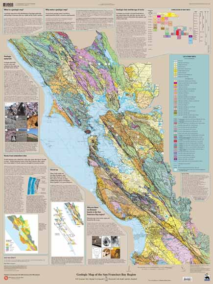
| The rocks and fossils of the San Francisco Bay region reveal that the geology there is the product of millions of years at the active western margin of North America. The result of this history is a complex mosaic of geologic materials and structures that form the landscape. A geologic map is one of the basic tools to understand the geology, geologic hazards, and geologic history of a region. With heightened public awareness about earthquake hazards leading up to the 100th anniversary of the 1906 San Francisco earthquake, the U.S. Geological Survey (USGS) is releasing new maps of the San Francisco Bay Area designed to give residents and others a new look at the geologic history and hazards of the region. The “Geologic Map of the San Francisco Bay region” shows the distribution of geologic materials and structures, demonstrates how geologists study the age and origin of the rocks and deposits that we live on, and reveals the complicated geologic history that has led to the landscape that shapes the Bay Area. |
Download this poster in standard resolution as a PDF document (36 x 48 inches; 21.6 MB)
Download this poster in high resolution as a PDF document (36 x 48 inches; 76.5 MB)
View the map in Google Earth™.
Download the companion poster to this one: USGS Scientific Investigations Map 2919, Map of Quaternary-active Faults in the San Francisco Bay Region, by R.W. Graymer, William Bryant, C.A. McCabe, Suzanne Hecker, and C.S. Prentice
For questions about the content of this report, contact Russ Graymer
 Visit the 1906 Earthquake Centennial Alliance.
Visit the San Francisco Bay Region Geology and Geologic Hazards website.
Visit the Earthquake Hazards Program – Northern California website.
| Help
| PDF help
| Publications main page | Western Scientific Investigations Maps | Printed copies of the poster are available for $7 each from:
USGS Information Services, Box 25286,
Federal Center, Denver, CO 80225
telephone: (888) ASK-USGS; e-mail: infoservices@usgs.gov
| Department of the Interior
| U.S. Geological Survey |
URL of this page: https://pubs.usgs.gov/sim/2006/2918/
Maintained by: Michael Diggles
Date created: April 18, 2006
Date last modified: April 24, 2007 (mfd)