

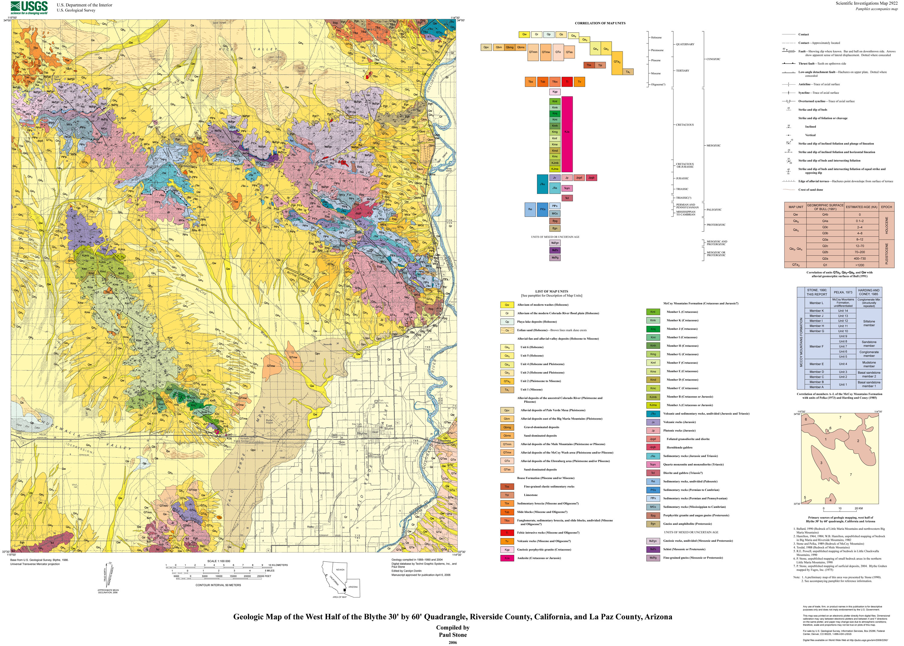
The Blythe 30' by 60' quadrangle is located along the Colorado River between southeastern California and western Arizona. This map depicts the geology of the west half of the Blythe quadrangle, which is mostly in California. The map area is a desert terrain consisting of mountain ranges surrounded by extensive alluvial fans and plains, including the flood plain of the Colorado River which covers the easternmost part of the area. Mountainous parts of the area, including the Big Maria, Little Maria, Riverside, McCoy, and Mule Mountains, consist of structurally complex rocks that range in age from Proterozoic to Miocene. Proterozoic gneiss and granite are overlain by Paleozoic to Early Jurassic metasedimentary rocks (mostly marble, quartzite, and schist) that are lithostratigraphically similar to coeval formations of the Colorado Plateau region to the east. The Paleozoic to Jurassic strata were deposited on the tectonically stable North American craton. These rocks are overlain by metamorphosed Jurassic volcanic rocks and are intruded by Jurassic plutonic rocks that represent part of a regionally extensive, northwest-trending magmatic arc. The overlying McCoy Mountains Formation, a very thick sequence of weakly metamorphosed sandstone and conglomerate of Jurassic(?) and Cretaceous age, accumulated in a rapidly subsiding depositional basin south of an east-trending belt of deformation and east of the north-trending Cretaceous Cordilleran magmatic arc. The McCoy Mountains Formation and older rocks were deformed, metamorphosed, and locally intruded by plutonic rocks in the Late Cretaceous. In Oligocene(?) to Miocene time, sedimentary and minor volcanic deposits accumulated locally, and the area was deformed by faulting. Tertiary rocks and their Proterozoic basement in the Riverside and northeastern Big Maria Mountains are in the upper plate of a low-angle normal (detachment) fault that lies within a region of major Early to Middle Miocene crustal extension. Surficial deposits of the flanking alluvial fans and plains range in age from late Miocene to Holocene. Among the oldest of these deposits are limestone and fine-grained clastic sediments of the late Miocene and (or) Pliocene Bouse Formation, which is commonly interpreted to represent an estuary or marine embayment connected to the proto-Gulf of California. Most of the surficial deposits younger than the Bouse Formation are composed of alluvium either derived from local mountain ranges or transported into the area by the Colorado River. Large parts of the area, particularly near the northern margin, are covered by eolian sand, and small parts are covered by playa sediments. |
| File
Name |
File
Type and Description |
File
Size |
| | ||
| FILES for VIEWING and PLOTTING |
||
| A Portable Document Format (PDF) file for viewing and printing a 22-page pamphlet that accompanies the map. The pamphlet contains a geologic interpretation and the description of map units. | 1.4 MB |
|
| PDF file of ~38" x 28" map sheet that can be used for viewing map in a browser, as well as for plotting at full scale (geologic map, description of map units, and correlation of map units) | 13.1 MB |
|
| JPG file of 10" x 8" 300 dpi version of the map sheet that can be used for viewing map in a browser or printing on letter-sized paper | 1.7 MB |
|
| README |
||
| ASCII-text readme file that explains the contents of the data file | 56 KB |
|
| DATA |
||
| Federal Geographic Data Committee (FGDC) compliant metadata file derived from the digital database | 64 KB |
|
| Compressed file that contains ARC/INFO (Environmental Systems Research Institute), version 8.1.2 coverages and associated tables | 712-KB file that opens into a 4.7-MB folder |
|
For questions about the content of this report, contact Paul Stone
Version history| Help
| PDF help
| Publications main page | Western Scientific Investigations Maps | This report is available via print on demand.
| Department of the Interior
| U.S. Geological Survey |
URL of this page: https://pubs.usgs.gov/sim/2006/2922/
Maintained by: Michael Diggles
Date created: July 2, 2006
Date last modified: January 18, 2007 (mfd)