
|
|
|
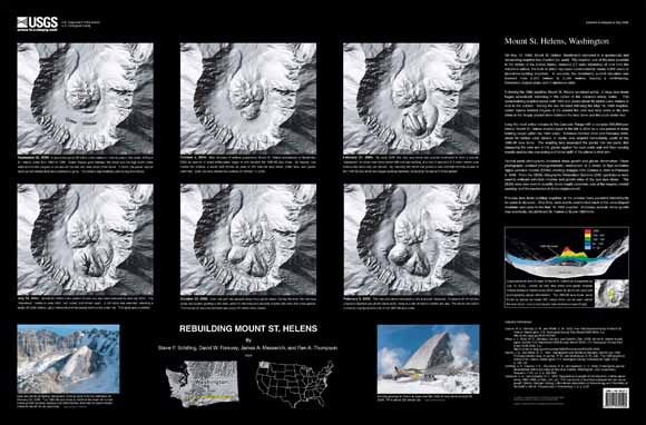
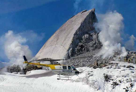
On May 18, 1980, Mount St. Helens, Washington exploded in a spectacular and devastating eruption that shocked the world. The eruption, one of the most powerful in the history of the United States, removed 2.7 cubic kilometers of rock from the volcano's edifice, the bulk of which had been constructed by nearly 4,000 years of lava-dome-building eruptions. In seconds, the mountain's summit elevation was lowered from 2,950 meters to 2,549 meters, leaving a north-facing, horseshoe-shaped crater over 2 kilometers wide. Following the 1980 eruption, Mount St. Helens remained active. A large lava dome began episodically extruding in the center of the volcano's empty crater. This dome-building eruption lasted until 1986 and added about 80 million cubic meters of rock to the volcano. During the two decades following the May 18, 1980 eruption, Crater Glacier formed tongues of ice around the east and west sides of the lava dome in the deeply shaded niche between the lava dome and the south crater wall. Long the most active volcano in the Cascade Range with a complex 300,000-year history, Mount St. Helens erupted again in the fall of 2004 as a new period of dome building began within the 1980 crater. Between October 2004 and February 2006, about 80 million cubic meters of dacite lava erupted immediately south of the 1980-86 lava dome. The erupting lava separated the glacier into two parts, first squeezing the east arm of the glacier against the east crater wall and then causing equally spectacular crevassing and broad uplift of the glacier's west arm. Vertical aerial photographs document dome growth and glacier deformation. These photographs enabled photogrammetric construction of a series of high-resolution digital elevation models (DEMs) showing changes from October 4, 2004 to February 9, 2006. From the DEMs, Geographic Information Systems (GIS) applications were used to estimate extruded volumes and growth rates of the new lava dome. The DEMs were also used to quantify dome height variations, size of the magma conduit opening, and the mechanics of dome emplacement. Previous lava-dome-building eruptions at the volcano have persisted intermittently for years to decades. Over time, such events constructed much of the cone-shaped mountain seen prior to the May 18, 1980 eruption. Someday, episodic dome growth may eventually rebuild Mount St. Helens to its pre-1980 form.
|
Download this map as a 38" x 25" PDF document (SIM2928.pdf; 1.6 MB)
Download a page-sized version of the map (SIM2928.jpg; 1.1 MB)
For questions about the content of this report, contact Steve Schilling
|
|
Download a current version of Adobe Reader for free
| Help
| PDF help
| Publications main page | Western Scientific Investigations Maps |
This map is also available from:
USGS Information
Services, Box 25286,
Federal Center, Denver, CO 80225
telephone: 1-888-ASK-USGS; e-mail: infoservices@usgs.gov