Scientific Investigations Map 2967
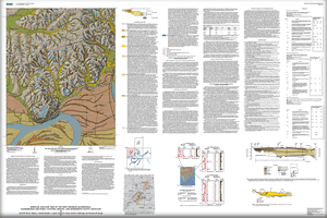 
Unconsolidated deposits of loess and silty to gravelly alluvium were mapped in the West Franklin quadrangle west of Evansville, Indiana. Map units are classified in terms of geologic origin (alluvium, loess, colluvium, lacustrine terrace deposits, and glacial outwash) and geologic age. All mapped materials were deposited less than 45,000 yr B.P. (late Pleistocene and Holocene). Deposits are characterized in detail and interpretations of their depositional environments were deduced from drill hole samples, landforms, and cone penetration soundings. Fossil wood collected under a creek valley in a drill hole at 6.4- and 10.6-m depths gave ages of 11,120±40 and 16,650±50 radiocarbon yr B.P., respectively, indicating filling of the valley during the waning phase of the Michigan glacial subepisode. Slackwater-lake deposits are present in the lower reaches of tributary streams to the Ohio River. The authors speculate on the significance of clearing of forests by European settlers and river engineering on sedimentation rates in the valleys. Peoria Silt (22,000-12,000 yr B.P.) mantles the uplands that lie north of the Ohio River floodplain. A geologic cross section based on five auger holes, drill hole lithologic logs, and a historical synopsis of the deposits are included in the report. The map was prepared for resource planning, educational purposes, and as a geologic framework to be used by seismologists who will make a probabilistic seismic hazard map of the region.
|
Version 1.0 Posted April 2007
|
Moore, D.W., Newell, W.L., Counts, R.C., Fraser, G.S., Fishbaugh, D.A., and Brandt, T.R., 2007, Surficial geologic map of the West Franklin quadrangle, Vanderburgh and Posey Counties, Indiana, and Henderson County, Kentucky: U.S. Geological Survey Scientific Investigations Map 2967, scale 1:24,000.

![]() U.S. Department of the Interior | U.S. Geological Survey
U.S. Department of the Interior | U.S. Geological Survey
URL: http://pubsdata.usgs.gov/pubs/sim/2007/2967/index.html
Questions or Assistance: Contact USGS
Last modified: Thursday, 01-Dec-2016 17:08:19 EST
