Western Earth Surface Processes
Warm Spring Canyon is located in the southeastern part of the Panamint Range in east-central California, 54 km south of Death Valley National Park headquarters at Furnace Creek Ranch. For the relatively small size of the area mapped (57 km2), an unusual variety of Proterozoic and Phanerozoic rocks is present. The outcrop distribution of these rocks largely resulted from movement on the east-west-striking, south-directed Butte Valley Thrust Fault of Jurassic age. The upper plate of the thrust fault comprises a basement of Paleoproterozoic schist and gneiss overlain by a thick sequence of Mesoproterozoic and Neoproterozoic rocks, the latter of which includes diamictite generally considered to be of glacial origin. The lower plate is composed of Devonian to Permian marine formations overlain by Jurassic volcanic and sedimentary rocks. Late Jurassic or Early Cretaceous plutons intrude rocks of the area, and one pluton intrudes the Butte Valley Thrust Fault. Low-angle detachment faults of presumed Tertiary age underlie large masses of Neoproterozoic dolomite in parts of the area. Movement on these faults predated emplacement of middle Miocene volcanic rocks in deep, east-striking paleovalleys. Excellent exposures of all the rocks and structural features in the area result from sparse vegetation in the dry desert climate and from deep erosion along Warm Spring Canyon and its tributaries.
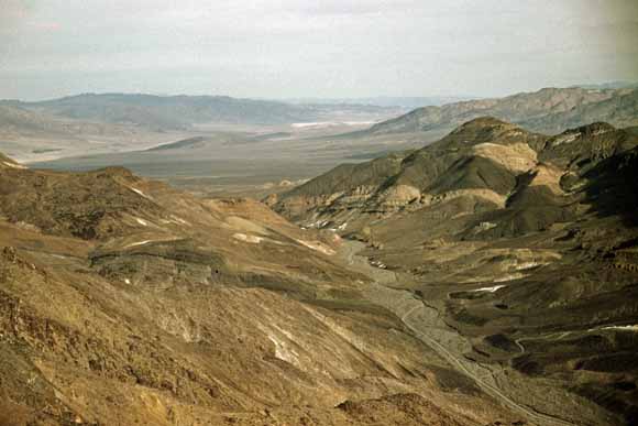
View of lower Warm Spring Canyon, southern Panamint Range, Death Valley National Park, California. On right (south) side of canyon, dark diabase sill (age about 1 Ga), one of many in area, intrudes light-colored dolomite of the Mesoproterozoic Crystal Spring Formation, locally forming talc deposits (white patches) by contact metamorphism. South-dipping strata in left foreground are basal beds of the Crystal Spring Formation. View is east-southeast into Death Valley. In distance, Black Mountains are on left, and Owlshead Mountains are on right. Photograph by C.T. Wrucke, 1951.
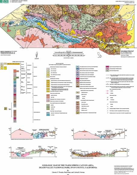
Download the map as a 27" x 33" PDF file. This map sheet that can be used for viewing map in a browser, as well as for plotting at full scale (geologic map, list of map units, correlation of map units, and cross sections) (SIM2974_map.pdf; 74.5 MB)
Download the Pamphlet to accompany the map as a 44-page PDF file. This pamphlet contains a geologic interpretation and the description of map units. (SIM2974_pamphlet_v1.1.pdf; 4.3 MB)
Readme file that lists and describes the digital dataset files linked below (SIM2974_readme.txt; 8 kB)
FGDC compliant metadata (SIM2974_met.txt; 56 kB)
Digital dataset as a compressed file. (SIM2974.tar.gz; 448-kB compressed file that expands to 156 MB)
For questions about the content of this report, contact Paul Stone
Suggested citation and version history
Download a free copy of the latest version of Adobe Reader.
|
Help |
PDF help |
Publications main page |
| Western Scientific Investigations Maps |
| Geologic Division |
Western Earth Surface Processes
|
This report is available via print on demand.

![]() U.S. Department of the Interior | U.S. Geological Survey
U.S. Department of the Interior | U.S. Geological Survey
URL: https://pubs.usgs.gov/sim/2007/2974/
Page Contact Information: Michael Diggles
Page Created: December 18, 2007
Page Last Modified: October 31, 2008