U.S. Geological Survey Scientific Investigations Map 2907
Descriptive Notes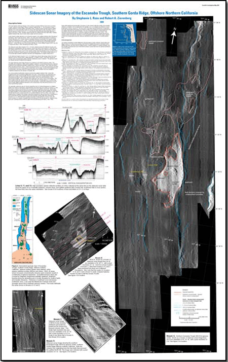
This map features sidescan imagery of the northern Escanaba (NESCA) site at the Escanaba Trough, southern Gorda Ridge, offshore northern California. The Escanaba Trough, a largely sediment-covered seafloor spreading center, contains at least six large massive sulfide deposits. It is a slow spreading center (2.5 cm/yr) with axial depths locally exceeding 3,300 m. Discrete igneous centers occur at 5- to 10-km intervals along this slow-spreading ridge. Basaltic magma intrudes the sediment fill of the axial valley, creating uplifted sediment hills, and, in some areas, erupts onto the sea floor. Large massive sulfide deposits occur along the margins of the uplifted sediment hills. The only active hydrothermal system is located on Central Hill where 220° C fluids construct anhydrite chimneys on pyrrhotite-rich massive sulfide mounds (Campbell and others, 1994). Central Hill is bounded by both ridge-parallel basement faults and a concentric set of faults that rim the top of the hill and may be associated with sill intrusion. Central Hill was one of the primary drill sites for Ocean Drilling Program (ODP) Leg 169. The sidescan sonar data (mosaics A, B, C, D) were collected aboard the National Oceanic and Atmospheric Administration (NOAA) research vessel Discoverer in the summer of 1996 with a 60-kHz system towed 100 to 200 m above the sea floor. Major faults and contacts are interpreted from the sidescan mosaics and 4.5-kHz seismic profiles collected simultaneously, as well as from previously conducted camera transects and submersible dives. The seismic profiles (lines 9, 11, 13) provide high-resolution subbottom structure and stratigraphy to a depth of about 50 m. In the sidescan images (mosaics A, B, C, D), bright areas denote high-energy returns from hard reflectors such as volcanic flows, sulfide deposits, or seafloor scarps. Dark areas denote low-energy returns and generally signify relatively undisturbed surface sediment. The grid lines mark one-minute intervals of latitude and longitude. The large sidescan sonar image (mosaic A) is centered on the NESCA igneous center. The spreading axis is flanked on either side by uplifted, sediment-covered terraces that show relatively continuous and undisturbed turbiditic sediment. These terraces bound the 4- to 5-km-wide neotectonic zone that is characterized by more closely spaced, small offset (<20 m) faults, volcanic flows (brightest area of backscatter), and areas where the seismic layering of the turbidites has been partially to completely disrupted by the intrusion of basaltic sills. The most prominent bathymetric features are the three uplifted sediment hills: Central Hill, Southwest Hill, and an unnamed uplifted hill to the north. These features are interpreted to be uplifted above large-volume basaltic intrusions emplaced near the basalt/sediment interface. Southwest Hill is adjacent to the zone of most recent faulting. This hill no longer retains the circular shape of the other hills due to slumps (lines 9, 11), which may have failed along faults related to the most recent spreading. Central Hill is interpreted to be the most recently uplifted sediment hill based on the morphology of the hill and the presence of an active hydrothermal system. The generally continuous area of volcanic basalt flow east of Central Hill appears as a distinct, bright sonar reflector stretching for approximately 6 km along axis (red contact on mosaic A). This flow may be related to the intrusion that is presumed to have uplifted Central Hill. Submersible observations indicate that lava flowed around the sediment hills and ponded against the eastern up-faulted turbidite-covered sediment terrace. Previously collected, deep-penetration seismic data indicate that the lavas overlie about 450 m of sediment (Morton and Fox, 1994). Late-stage emplacement of magma in the shallow subsurface beneath the exposed lava flow is interpreted to have domed the lava flow, forming the east-west-trending volcanic ridge with a fissured top (mosaics A, B, C). North Hill at the southern Escanaba Trough (SESCA) volcanic center also shows evidence for eruption of basaltic flows from the base of the hill (mosaic D); eruption of the flows was contemporaneous with the uplift of the hill. Areas with relatively low backscatter, but where 4.5-kHz seismic reflection profiles show basaltic reflectors at shallow (<50 m) depth below the turbidite cover, are mapped as sediment-covered basalt (pink contacts, mosaic A). The area north of the large exposed basalt flow is interpreted from both submersible observations and seismic profiles to be sediment-covered basalt flows that are slightly older than the exposed basalt. The area of basalt just north of Central Hill may represent a buried basalt flow or a shallowly emplaced sill. The contacts of the buried basalts are shown as solid lines where they can be readily inferred from seismic profiles and sidescan reflections of the topographic expressions of their edges; dashed contacts are extrapolated using the sidescan reflectance where there are no crossing seismic lines. |
First posted September 29, 2009
For additional information: This report is presented in Portable Document Format (PDF); the latest version of Adobe Reader or similar software is required to view it. Download the latest version of Adobe Reader, free of charge. |
Ross, Stephanie L., and Zierenberg, Robert A., 2009, Sidescan Sonar Imagery of the Escanaba Trough, Southern Gorda Ridge, Offshore Northern California: Scientific Investigations Map 2907, scale 1:25,000.

![]() U.S. Department of the Interior |
U.S. Geological Survey
U.S. Department of the Interior |
U.S. Geological Survey
URL: http://
pubsdata.usgs.gov
/pubs/sim/2907/index.html
Page Contact Information: USGS Publications Team
Page Last Modified: Thursday, 01-Dec-2016 17:15:48 EST
