Abstract
 Debris flows pose substantial threats to life, property, infrastructure, and water
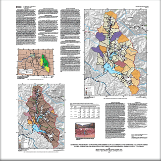
resources. Post-wildfire debris flows may be of catastrophic proportions compared to debris flows occurring in unburned areas. During 2006, the U.S. Geological Survey (USGS), in cooperation with the Northern Colorado Water Conservancy District, initiated a pre-wildfire study to determine the potential for post-wildfire debris flows in the Three Lakes watershed, Grand County, Colorado. The objective was to estimate the probability of post-wildfire debris flows and to estimate the approximate volumes of debris flows from 109 subbasins in the Three Lakes watershed in order to provide the Northern Colorado Water Conservancy District with a relative measure of which subbasins might constitute the most serious debris flow hazards. Debris flows pose substantial threats to life, property, infrastructure, and water
resources. Post-wildfire debris flows may be of catastrophic proportions compared to debris flows occurring in unburned areas. During 2006, the U.S. Geological Survey (USGS), in cooperation with the Northern Colorado Water Conservancy District, initiated a pre-wildfire study to determine the potential for post-wildfire debris flows in the Three Lakes watershed, Grand County, Colorado. The objective was to estimate the probability of post-wildfire debris flows and to estimate the approximate volumes of debris flows from 109 subbasins in the Three Lakes watershed in order to provide the Northern Colorado Water Conservancy District with a relative measure of which subbasins might constitute the most serious debris flow hazards.
This report describes the results of the study and provides estimated probabilities of debris-flow occurrence and the estimated volumes of debris flow that could be produced in 109 subbasins of the watershed under an assumed moderate- to high-burn severity of all forested areas. The estimates are needed because the Three Lakes watershed includes communities and substantial water-resources and water-supply infrastructure that are important to residents both east and west of the Continental Divide.
Using information provided in this report, land and water-supply managers can consider where to concentrate pre-wildfire planning, pre-wildfire preparedness, and pre-wildfire mitigation in advance of wildfires. Also, in the event of a large wildfire, this information will help managers identify the watersheds with the greatest post-wildfire debris-flow hazards.
|

