Astrogeology Research Program
The Magellan spacecraft orbited Venus from August 10, 1990, until it plunged into the Venusian atmosphere on October 12, 1994. Magellan Mission objectives included (1) improving the knowledge of the geological processes, surface properties, and geologic history of Venus by analysis of surface radar characteristics, topography, and morphology and (2) improving the knowledge of the geophysics of Venus by analysis of Venusian gravity.
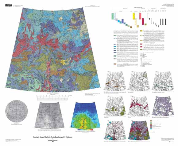
The Beta Regio quadrangle (V17) is in the northern hemisphere of Venus and extends from latitude 25° to 50° N. and from longitude 270° to 300° E. Its southern part covers a significant part of the prominent and generally domal topographic rise of Beta Regio and the northern area of the less prominent and generally flat topped rise of Hyndla Regio. Part of the lowland plains of Guinevere Planitia, most of which is below the 6,051 km datum, occupies the northern part of the quadrangle. Within the plains but close to the northeastern part of the Beta Regio rise there is a radiating system of radar-bright lineaments and grooves centered at Wohpe Tholus. The Beta Regio rise has two summits: Rhea Mons and Theia Mons, both of which reach altitudes more than 5 km above the datum. Rhea Mons is completely within the V-17 quadrangle. Only the northern part of Theia Mons is in the quadrangle. From north to south the Beta Regio rise is cut by the very prominent topographic trough of Devana Chasma, the deepest parts of which locally reach the altitude levels of the Guinevere Planitia. At the eastern and western flanks of Beta Regio rise, correspondingly, are the troughs of Aikhylu Chasma and Latona Chasma, which topographically are much less prominent than Devana Chasma. Close to Aikhylu Chasma there is a channel-like feature named Omutnitsa Vallis. The northern part of the Beta Regio rise is marked by the fracture belt of Agrona Linea.
Download this map as an ~45" x 37" PDF document (sim3023_map.pdf; 55.8 MB)
Download the accompanying pamphlet as a 36-page PDF document (sim3023_pamphlet.pdf; 20.8 MB)
For questions about the content of this report, contact Ken Tanaka
Suggested citation and version history
Download a free copy of the current version of Adobe Reader.
| Help
| PDF help
| Publications main page | Other Planetary Maps |
| Geologic
Division | Astrogeology Research Program
|
This map is available in paper form from:
USGS Information Services, Box 25286,
Federal Center, Denver, CO 80225
telephone: (888) ASK-USGS; e-mail: infoservices@usgs.gov

![]() U.S. Department of the Interior | U.S. Geological Survey
U.S. Department of the Interior | U.S. Geological Survey
URL: https://pubs.usgs.gov/sim/3023/
Page Contact Information: Michael Diggles
Page Created: October 30, 2008
Page Last Modified: October 30, 2008