Scientific Investigations Map 3037
|
Abstract 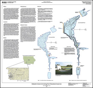
The U.S. Geological Survey, in cooperation with the Iowa Department of Natural Resources, conducted bathymetric surveys on seven lakes in Iowa during 2005 (Arrowhead Pond, Central Park Lake, Lake Keomah, Manteno Park Pond, Lake Miami, Springbrook Lake, and Yellow Smoke Lake). The surveys were conducted to provide the Iowa Department of Natural Resources with information for the development of total maximum daily load limits, particularly for estimating sediment load and deposition rates. The bathymetric surveys provide a baseline for future work on sediment loads and deposition rates for these lakes. All of the lakes surveyed in 2005 are man-made lakes with fixed spillways. Bathymetric data were collected using boat-mounted, differential global positioning system, echo depth-sounding equipment, and computer software. Data were processed with commercial hydrographic software and exported into a geographic information system for mapping and calculating area and volume. Lake volume estimates ranged from 47,784,000 cubic feet (1,100 acre-feet) at Lake Miami to 2,595,000 cubic feet (60 acre-feet) at Manteno Park Pond. Surface area estimates ranged from 5,454,000 square feet (125 acres) at Lake Miami to 558,000 square feet (13 acres) at Springbrook Lake. |
Version 1.0 Posted September 2008
For additional information contact: Part or all of this report is presented in Portable Document Format (PDF); the latest version of Adobe Reader or similar software is required to view it. Download the latest version of Adobe Reader, free of charge. |
Linhart, S.M., and Lund, K.D., 2008, Bathymetric contour maps of lakes surveyed in Iowa in 2005: U.S. Geological Survey Scientific Investigations Map 3037, 7 sheets.

![]() U.S. Department of the Interior | U.S. Geological Survey
U.S. Department of the Interior | U.S. Geological Survey
URL: http://pubsdata.usgs.gov/pubs/sim/3037/index.html
Questions or Assistance: Contact USGS
Last modified: Thursday, 01-Dec-2016 17:11:38 EST
