Scientific Investigations Map 3044
Abstract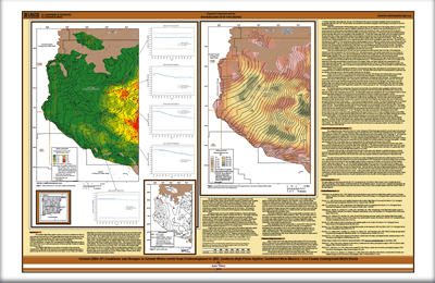
The Southern High Plains aquifer is the principal aquifer and primary source of water in southeastern New Mexico. The Lea County portion of the aquifer covers approximately the northern two thirds of the 4,393-square-mile county. Successful water-supply planning for New Mexico’s Southern High Plains requires knowledge of the current aquifer conditions and a context from which to estimate future trends given current aquifer-management policy. Maps representing water-level declines, current (2007) water levels, aquifer saturated thickness, and depth to water accompanied by hydrographs from representative wells for the Southern High Plains aquifer in the Lea County Underground Water Basin were prepared in cooperation with the New Mexico Office of the State Engineer. Results of this mapping effort show the water level has declined as much as 97 feet in the Lea County Underground Water Basin from predevelopment (1914-54) to 2007 with rates as high as 0.88 feet per year. |
Version 1.0 Posted December 2008 Part or all of this report is presented in Portable Document Format (PDF); the latest version of Adobe Reader or similar software is required to view it. Download the latest version of Adobe Reader, free of charge. |
Tillery, A., 2008, Current (2004-07) conditions and changes in ground-water levels from predevelopment to 2007, Southern High Plains aquifer, southeast New Mexico—Lea County Underground Water Basin: U.S. Geological Survey Scientific Investigations Map 3044.

![]() U.S. Department of the Interior | U.S. Geological Survey
U.S. Department of the Interior | U.S. Geological Survey
URL: http://pubsdata.usgs.gov/pubs/sim/3044/index.html
Questions or Assistance: Contact USGS
Last modified: Thursday, 01-Dec-2016 17:12:35 EST
