Scientific Investigations Map 3048
Abstract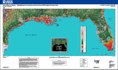
In support of U.S. Geological Survey (USGS) disaster preparedness efforts, this map depicts a color shaded relief representation of the area surrounding the Gulf of Mexico. The first 30 feet of relief above mean sea level are displayed as brightly colored 5-foot elevation bands, which highlight low-elevation areas at a coarse spatial resolution. Standard USGS National Elevation Dataset (NED) 1 arc-second (nominally 30-meter) digital elevation model (DEM) data are the basis for the map, which is designed to be used at a broad scale and for informational purposes only. The NED data were derived from the original 1:24,000-scale USGS topographic map bare-earth contours, which were converted into gridded quadrangle-based DEM tiles at a constant post spacing (grid cell size) of either 30 meters (data before the mid-1990s data) or 10 meters (mid-1990s and later data). These individual-quadrangle DEMs were then converted to spherical coordinates (latitude/longitude decimal degrees) and edge-matched to ensure seamlessness. Approximately one-half of the area shown on this map has DEM source data at a 30-meter resolution, with the remaining half consisting of 10-meter contour-derived DEM data or higher-resolution LIDAR data. Areas below sea level typically are surrounded by levees or some other type of flood-control structures. State and county boundary, hydrography, city, and road layers were modified from USGS National Atlas data downloaded in 2003. The NED data were downloaded in 2005. |
Version 1.0 Posted November 2008 For additional information contact: Part or all of this report is presented in Portable Document Format (PDF); the latest version of Adobe Reader or similar software is required to view it. Download the latest version of Adobe Reader, free of charge. |
Kosovich, J.J., 2008, Gulf of Mexico Region—Highlighting low-lying areas derived from USGS digital elevation data: U.S. Geological Survey Scientific Investigations Map 3048, scale 1:1,350,000.

![]() U.S. Department of the Interior | U.S. Geological Survey
U.S. Department of the Interior | U.S. Geological Survey
URL: http://pubsdata.usgs.gov/pubs/sim/3048/index.html
Questions or Assistance: Contact USGS
Last modified: Thursday, 01-Dec-2016 17:12:12 EST
