Scientific Investigations Map 3055
|
First posted April 28, 2009
For additional information, contact: Part or all of this report is presented in Portable Document Format (PDF). For best results viewing and printing PDF documents, it is recommended that you download the documents to your computer and open them with Adobe Reader. PDF documents opened from your browser may not display or print as intended. Download the latest version of Adobe Reader, free of charge. |
Fine, J.M., 2008, Hydrogeologic framework of Onslow County, North Carolina, 2008: U.S. Geological Survey Scientific Investigations Map 3055, 1 sheet. (available online at https://pubs.usgs.gov/sim/3055/).
Abstract
Introduction
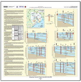
Study Area
Methods
Surficial Aquifer
Upper and Lower Castle Hayne Aquifers
Beaufort Aquifer
Peedee Aquifer
Black Creek Aquifer
Upper and Lower Cape Fear Aquifers
Summary
References

![]() U.S. Department of the Interior |
U.S. Geological Survey
U.S. Department of the Interior |
U.S. Geological Survey
URL: http://pubsdata.usgs.gov/pubs/sim/3055/index.html
Page Contact Information: GS Pubs Web Contact
Page Last Modified: Thursday, 01-Dec-2016 17:12:52 EST