U.S. Geological Survey Scientific Investigations Map 3065
Introduction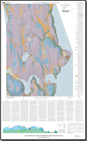
This geologic map, approximately coincident with the east half of the Seattle North 7.5 x 15’ quadrangle (herein, informally called the “Seattle NE map”), covers nearly half of the City of Seattle and reaches from Lake Washington across to the Puget Sound shoreline. Land uses are mainly residential, but extensive commercial districts are located in the Northgate neighborhood, adjacent to the University of Washington, and along the corridors of Aurora Avenue North and Lake City Way. Industrial activity is concentrated along the Lake Washington Ship Canal and around Lake Union. One small piece of land outside of the quadrangle boundaries, at the west edge of the Bellevue North quadrangle, is included on this map for geographic continuity. Conversely, a small area in the northeast corner of the Seattle North quadrangle, on the eastside of Lake Washington, is excluded from this map. Within the boundaries of the map area are two large urban lakes, including the most heavily visited park in the State of Washington (Green Lake Park); a stream (Thornton Creek) that still hosts anadromous salmon despite having its headwaters in a golfcourse and a shopping center; parts of three cities, with a combined residential population of about 300,000 people; and the region’s premier research institution, the University of Washington. The north boundary of the map is roughly NE 168th Street in the cities of Shoreline and Lake Forest Park, and the south boundary corresponds to Mercer Street in Seattle. The west boundary is 15th Avenue W (and NW), and the east boundary is formed by Lake Washington. Elevations range from sea level to a maximum of 165 m (541 ft), the latter on a broad till-covered knob in the city of Shoreline near the northwest corner of the map. Previous geologic maps of this area include those of Waldron and others (1962), Galster and Laprade (1991), and Yount and others (1993). Seattle lies within the Puget Lowland, an elongate structural and topographic basin between the Cascade Range and Olympic Mountains. The Seattle area has been glaciated repeatedly during the past two million years by coalescing glaciers that advanced southward from British Columbia. The landscape we see today was molded by cyclic glacial scouring and deposition and later modified by landsliding and stream erosion. The last ice sheet reached the central Puget Sound region about 14,500 years ago, as measured by 14C dating, and it had retreated from this area by 13,650 14C yr B.P. (equivalent calendar years are about 17,600 and 16,600 years ago; Porter and Swanson, 1998). Seattle now sits atop a complex and incomplete succession of interleaved glacial and nonglacial deposits that overlie an irregular bedrock surface. These glacial and nonglacial deposits vary laterally in both texture and thickness, and they contain many local unconformities. In addition, they have been deformed by faults and folds, at least as recently as 1,100 years ago, and this deformation further complicates the geologic record. The landforms and near-surface deposits that cover much of the Seattle NE map area record a relatively brief, recent interval of the region’s geologic history. The topography is dominated in the north by a broad, fluted, and south-sloping upland plateau, which gives way to a more complex set of elongated hills in the map’s southern half. The valleys of Pipers Creek, Green Lake, and Thornton Creek mark the transition between these two topographic areas. Most of the uplands are mantled by a rolling surface of sand (unit Qva) and till (unit Qvt) deposited during the last occupation of the Puget Lowland by a continental ice sheet. Beneath these ice sheet deposits is a complex succession of older sediments that extends far below sea level across most of the map area. These older sediments are now locally exposed where modern erosion and landslides have sliced through the edge of the upland, and where subglacial processes apparently left these older sediments largely free of overlying sediments. Lack of overlying sediments is particularly evident on the hillslopes above Thornton Creek, adjacent to Lake Washington, and on the flanks of Capitol Hill. |
For additional information: Part of this report is presented in Portable Document Format (PDF); the latest version of Adobe Reader or similar software is required to view it. Download the latest version of Adobe Reader, free of charge. |
Booth, Derek B., Troost, Kathy Goetz, and Schimel, Scott A., 2009, Geologic map of northeastern Seattle (part of the Seattle North 7.5' x 15' quadrangle), King County,Washington: U.S. Geological Survey Scientific Investigations Map 3065, scale 1:12000 and database.

![]() U.S. Department of the Interior |
U.S. Geological Survey
U.S. Department of the Interior |
U.S. Geological Survey
URL: http://
pubsdata.usgs.gov
/pubs/sim/3065/index.html
Page Contact Information: USGS Publications Team
Page Last Modified: Thursday, 01-Dec-2016 17:17:27 EST
