Scientific Investigations Map 3074
Abstract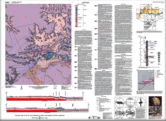
This map summarizes the geology of the St. Joe 7.5-minute quadrangle in the Ozark Plateaus region of northern Arkansas. Geologically, the area lies on the southern flank of the Ozark dome, an uplift that exposes oldest rocks at its center in Missouri. Physiographically, the St. Joe quadrangle lies within the Springfield Plateau, a topographic surface generally held up by Mississippian cherty limestone. The quadrangle also contains isolated mountains (for example, Pilot Mountain) capped by Pennsylvanian rocks that are erosional outliers of the higher Boston Mountains plateau to the south. Tomahawk Creek, a tributary of the Buffalo River, flows through the eastern part of the map area, enhancing bedrock erosion. Exposed bedrock of this region comprises an approximately 1,300-ft-thick sequence of Ordovician, Mississippian, and Pennsylvanian carbonate and clastic sedimentary rocks that have been mildly deformed by a series of faults and folds. The geology of the St. Joe quadrangle was mapped by McKnight (1935) as part of a larger area at 1:125,000 scale. The current map confirms many features of this previous study, but it also identifies new structures and uses a revised stratigraphy. Mapping for this study was conducted by field inspection of numerous sites and was compiled as a 1:24,000-scale geographic information system (GIS) database. Locations and elevations of sites were determined with the aid of a global positioning satellite receiver and a hand-held barometric altimeter that was frequently recalibrated at points of known elevation. Hill-shade-relief and slope maps derived from a U.S. Geological Survey 10-m digital elevation model as well as U.S. Geological Survey orthophotographs from 2000 were used to help trace ledge-forming units between field traverses within the Upper Mississippian and Pennsylvanian part of the stratigraphic sequence. Strikes and dips of beds were typically measured along stream drainages or at well-exposed ledges. Beds dipping less than 2° are shown as horizontal. Structure contours constructed on the base of the Boone Formation were hand drawn based on elevations of control points on both lower and upper contacts of the Boone Formation as well as other limiting information on their maximum or minimum elevations.¬ |
First posted May 27, 2009 For additional information contact: Part or all of this report is presented in Portable Document Format (PDF); the latest version of Adobe Reader or similar software is required to view it. Download the latest version of Adobe Reader, free of charge. |
Hudson, M.R., and Turner, K.J., 2009, Geologic map of the St. Joe quadrangle, Searcy and Marion Counties, Arkansas: U.S. Geological Survey Scientific Investigations Map 3074, scale 1:24,000.

![]() U.S. Department of the Interior |
U.S. Geological Survey
U.S. Department of the Interior |
U.S. Geological Survey
URL: http://pubsdata.usgs.gov/pubs/sim/3074/index.html
Page Contact Information: GS Pubs Web Contact
Page Last Modified: Thursday, 01-Dec-2016 17:14:45 EST
