Scientific Investigations Map 3087
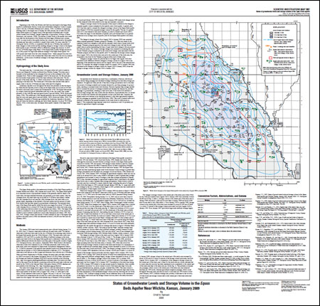
IntroductionBeginning in the 1940s, the Wichita well field was developed in the Equus Beds aquifer in southwestern Harvey County and northwestern Sedgwick County to supply water to the city of Wichita (Williams and Lohman, 1949). In addition to supplying drinking water to the largest city in Kansas, the other primary use of water from the Equus Beds aquifer is to irrigate crops in this agriculture-dominated part of south-central Kansas (Rich Eubank, Kansas Department of Agriculture, Division of Water Resources, oral commun., 2008). The decline of water levels in the aquifer were noted soon after the development of the Wichita well field began (Williams and Lohman, 1949). As water levels in the aquifer decline, the volume of water stored in the aquifer decreases and less water is available to supply future needs. For many years the U.S. Geological Survey (USGS), in cooperation with the city of Wichita, has monitored these changes in water levels and the resulting changes in storage volume in the Equus Beds aquifer as part of Wichita's effort to effectively manage this resource. In 2007, the city of Wichita began using Phase I of the Equus Beds Aquifer Storage and Recovery (ASR) project for large-scale artificial recharge of the Equus Beds aquifer. The ASR project uses water from the Little Arkansas River—either pumped from the river directly or from wells in the riverbank that obtain their water from the river by induced infiltration—as the source of artificial recharge to the Equus Beds aquifer (City of Wichita, 2009). |
Posted July 29, 2009 For additional information contact: Part or all of this report is presented in Portable Document Format (PDF); the latest version of Adobe Reader or similar software is required to view it. Download the latest version of Adobe Reader, free of charge. |
Hansen, C.V., 2009, Status of groundwater levels and storage volume in the Equus Beds aquifer near Wichita, Kansas, January 2009: U.S. Geological Survey Scientific Investigations Map 3087, 1 sheet.

![]() U.S. Department of the Interior |
U.S. Geological Survey
U.S. Department of the Interior |
U.S. Geological Survey
URL: http://pubsdata.usgs.gov/pubs/sim/3087/index.html
Page Contact Information: GS Pubs Web Contact
Page Last Modified: Thursday, 01-Dec-2016 17:15:21 EST
